
Durango Bill's
Paleogeography (Historical Geology) Research
Evolution of the Colorado River and its Tributaries
by
Bill Butler
Evolution of the Colorado River and its Tributaries
including Formation and Origin of the Grand Canyon
Geologic History of the Grand Canyon
Part 3 – Oligocene until the Day Before the Event
Oligocene (About
38 to 23 million years ago)
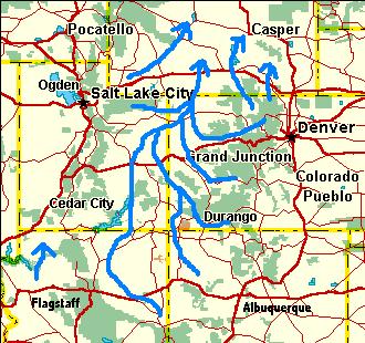
(Timing was updated on 6/21/04. Before this update, it was assumed that river systems that had been flowing from Colorado northward into Wyoming reversed to flow westward sometime during the Oligocene. Dating from the Bishop Conglomerate (See Harpers Corner) now indicates river patterns shifted about the end of the Oligocene.)
 As the Eocene drew to
a close, Utah’s Uinta Basin stopped sinking (and began an
isostatic rebound early in the Miocene). This along with
general uplifts across southern Wyoming and the Rabbit Ears
Range in northern Colorado resulted in major changes in river
systems across eastern Utah and western Colorado at the end of
the Oligocene. (See the Gore Range
section in the appendix for more information on the Rabbit
Ears uplift.) About 20 to 25 million years ago, rivers that
had been flowing north from Colorado into Wyoming were forced
to change direction and flow west into Utah. (See next
illustration) Lake Uinta filled in with silt and
subsequently its southern portion began to rise above the
surrounding terrain about early/mid Miocene time. Basin and
range stretching also began at this time. The immediate impact
of this stretching was to open river exit paths from Utah
northward into Idaho. Late in the Oligocene, Basin and Range
stretching initiated the destruction of the high ground
southwest of Arizona’s Mogollon Rim – setting the stage for
later events. (Note: There is a wide time slot open to these
events, and local delays into the early Miocene would not
upset the relative order.)
As the Eocene drew to
a close, Utah’s Uinta Basin stopped sinking (and began an
isostatic rebound early in the Miocene). This along with
general uplifts across southern Wyoming and the Rabbit Ears
Range in northern Colorado resulted in major changes in river
systems across eastern Utah and western Colorado at the end of
the Oligocene. (See the Gore Range
section in the appendix for more information on the Rabbit
Ears uplift.) About 20 to 25 million years ago, rivers that
had been flowing north from Colorado into Wyoming were forced
to change direction and flow west into Utah. (See next
illustration) Lake Uinta filled in with silt and
subsequently its southern portion began to rise above the
surrounding terrain about early/mid Miocene time. Basin and
range stretching also began at this time. The immediate impact
of this stretching was to open river exit paths from Utah
northward into Idaho. Late in the Oligocene, Basin and Range
stretching initiated the destruction of the high ground
southwest of Arizona’s Mogollon Rim – setting the stage for
later events. (Note: There is a wide time slot open to these
events, and local delays into the early Miocene would not
upset the relative order.)
 The timing of the
Wyoming and Colorado uplifts has to be inferred from the
relative order of events in the Uinta Basin / Tavaputs
Plateau area. It is probably safe to assume that river
flow was southwest to northeast across the Uinta Basin
throughout the Eocene. This was when the Green River Formation
was deposited in layers that now top the Tavaputs Plateau.
Sometime after the Eocene, river flow changed direction across
the Uinta Basin. Today, the Green/Yampa River flows southward
through the Tavaputs. The Eocene age Green River Formation is
now 4,000 feet above the river. The only relative order that
seems logical is:
The timing of the
Wyoming and Colorado uplifts has to be inferred from the
relative order of events in the Uinta Basin / Tavaputs
Plateau area. It is probably safe to assume that river
flow was southwest to northeast across the Uinta Basin
throughout the Eocene. This was when the Green River Formation
was deposited in layers that now top the Tavaputs Plateau.
Sometime after the Eocene, river flow changed direction across
the Uinta Basin. Today, the Green/Yampa River flows southward
through the Tavaputs. The Eocene age Green River Formation is
now 4,000 feet above the river. The only relative order that
seems logical is:
1) River flow across the Uinta Basin / Tavaputs was from southwest to northeast.
2) River flow was reversed to NNE to SSW. (The Yampa/Green course is established)
3) The Tavaputs rises, and the Yampa/Green starts digging Desolation Canyon.
We know event 1) belongs to the Eocene. Events 2) and 3) have to be spread over the Oligocene, Miocene, and the 5 million years since the Miocene. All current river paths were in place as of the “Grand Canyon” event 5.4 million years ago (or very shortly thereafter). Thus, most of event 3) has to take place during the Miocene. By a process of elimination, river reversal in all probability has to take place about late Oligocene / early Miocene. (Added 5/21/04: Recent dating evidence shows a 29 million year age for a volcanic ash fall within the Bishop Conglomerate. Deposits of the Bishop Conglomerate at the east end of Dinosaur Monument show that river flow was still west to east at this time. This points to reversal of river flow about 20 to 25 million years ago.)
After timing is in place, we have to use whatever evidence is available to derive the tectonics that caused the shift in river patterns. Hard evidence is only partially available; thus, for the remainder we have to infer what took place.
The Yampa River, which had formerly flowed north from Craig, Colorado into Wyoming, turned west to establish its present course. This new westward course approximated today’s course thru the present highlands of Dinosaur National Monument. (These highlands were still lowlands until they underwent renewed uplift in the last 5 million years. Most of the Eocene deposits extended from Wyoming around the east and south sides of the Uintas and then south to the Tavaputs. The extreme eastern end of the Uinta Mountains had been gradually eroded down to this level and was later covered by the upper layers of the Browns Park Formation.) From the Colorado/Utah border, the new course of the Yampa followed the current path of the Green River to just south of the town of Green River, Utah where it joined the Colorado. (This is the new path for the Colorado, which also relocated about late Oligocene / early Miocene time. See the section on the Colorado River starting two paragraphs down.) It should be noted that the Upper Green River would not join the river system until mid Miocene time. Early in the Miocene the Tavaputs Plateau began to rise, but the Yampa had already established the path that would become Desolation Canyon.
The westward flowing
White and Little Snake Rivers also formed at this time as
tributaries to the Yampa. Just as the Colorado River had to be
in place before the White River Plateau rose (see below), the
White River also had to be in place prior to this uplift. The
White River currently splits the north side of the White River
Plateau with the main part of the plateau to the south and
White (Oak) Ridge to the north. The resulting broad canyon is
over 1,500 feet deep. Big Beaver Creek flows southward into
the plateau just to the east of White (Oak) Ridge to join the
White River. Based on current topography Big Beaver Creek
should have flowed westward just north of the ridge. Instead,
it continues southward through rising strata to cut a canyon
1,000 feet deep before it joins the White River. This requires
Big Beaver Creek to be in place before the White River Plateau
rose. Then as the plateau rose, the stream acted as a
stationary band saw cutting into the rising block.
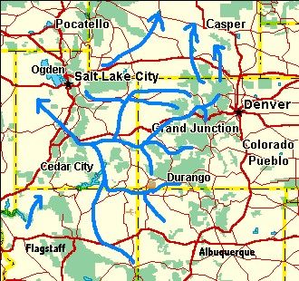
The upper Colorado River, which formerly flowed north from Kremmling, Colorado into Wyoming, found a new route toward the west-southwest. (See the Gore Range sections in the appendix for more information on this change in direction.) When the current Gore Range rose later during the Miocene, the river was in place ready to carve Gore Canyon. Further downstream the river again was ready when the White River Plateau also rose in Miocene time. Glenwood Canyon was the result. (More recent evidence implies most of the Gore Range and White River Plateau uplifts have occurred in the last 5 million years.) The new route for the Colorado then continued west across Utah.
Further south, the
Gunnison also turned west and met the Colorado River about 15
miles south of the present town of Grand Junction, CO; and
together they crossed the Uncompahgre Plateau at Unaweep
Canyon. (Please see 1st diagram, page 307, Roadside
Geology of Colorado.) The Uncompahge Plateau was much lower at
this time as it had not undergone the major uplift that
started during the Miocene (Roadside Geology of Colorado –
page 264). It is most likely that the exposed surface layer in
the Unaweep area was the easily eroded Mancos Shale, as it
would have provided a convenient low area.
At Gateway, CO, the Colorado River was joined by the ancestral San Juan River, which was still flowing north using the present course of the Dolores River. (It should be noted that the southern end of the San Juan was about to change its course leaving just the Dolores as the tributary). The combination continued west to just south of the Tavaputs Plateau.
The ancestral Yampa River joined the new Colorado south of the Tavaputs near the present town of Green River, Utah. From here, the river continued westward establishing a route near and just south of the present highway I-70 until it reached the present location of the salt deserts of western Utah. Then it turned north to join the Snake River (or possibly the northward flowing ancestors of the Salmon River system). Gravel deposits on the North Promontory Mountains straddling highway I-84 in northern Utah may have originated later in the Miocene from this route. (The gravel deposits are shown on page 218, Roadside Geology of Utah, but how they got there is speculative.)
Later in the Miocene, the climate was significantly drier. During these dry periods the river dried up in Utah’s western deserts leaving behind a lot of salt. Basin and range stretching was creating intermountain basins throughout western Utah and these would provide a dumping ground for any silt and salt the river brought in. (20,000 years ago “freshwater” Lake Bonneville occupied much of current Utah, and drained out to the north. The current salt in the Great Salt Lake has leached out from these old deposits.)
Further south, the Oligocene saw volcanic activity break out across southern Utah, northern Arizona, western Colorado and western New Mexico. Volcanic activity included both surface eruptions and underground intrusions. Additionally, several local uplifts started, with this activity continuing into the Miocene. Several of these uplifts were near the Four Corners area including New Mexico’s Chuska Mountains, and a large area stretching from Colorado’s La Plata Mountains to Utah’s Abajo Mountains. (These intrusions and uplift were the result of “an essentially continuous, intracontinental magmatic zone extending from Reno to the San Juan Mountains during the Oligocene and early Miocene.” http://geology.cr.usgs.gov/pub/bulletins/b2158/B2158-4.pdf)
The regional uplift
extending from the Abajos and La Platas (and to a diminishing
degree southward toward New Mexico) would change the course of
the San Juan River about late Oligocene to early Miocene time.
(This time period is an estimate based on widespread volcanic
activity that broke out in the western San Juan Mountains
between 25 and 30 million years ago. (Field Trip Guidebook -
page 24)) (Note: The igneous intrusions in the La Plata
Mountains around the K-T boundary time produced local uplifts,
but these uplifts were only local in geographic area. The
Oligocene/Miocene renewed uplift extended over a much larger
area.)
When the Abajo and La Plata Mountains (and nearby terrain) underwent renewed uplift, the San Juan River which had flowed west-northwest just to the south of the Durango area was diverted further south into New Mexico. Then, from northwestern New Mexico the easiest route for the San Juan River to get to the former Lake Uinta lowlands was to travel westward in-between Arizona’s Defiance Plateau and Utah’s Monument Upwarp. Thus, the new path for the San Juan was reset southward to Farmington, NM and thence west to near the eastern end of Lake Powell. (Of note: West of Mexican Hat, Utah this route was south of the current Goosenecks/San Juan Canyon area.) There it could turn north, and after joining the Little Colorado the combination flowed north to eventually join the Colorado. The old path of the San Juan from McPhee Reservoir north would still be used by one of its tributaries – the Dolores, and this portion is still called the Dolores River today. (See the Appendix for more details.)
In northern Arizona, the late Eocene / early Oligocene renewed uplift of the Kaibab Plateau forced a relocation of the Little Colorado River. (See bottom of page 56, Fission-Track Dating GCS2000 abstracts regarding this date. However, we disagree with the hypothesis that the ancestral Colorado River was at this locality at the time.)
The climate was turning drier, and this time the reduced flow of the Little Colorado River was not able to cut down fast enough to maintain its old course across the Kaibab. (Alternately, by the Oligocene the Little Colorado’s downstream gradient was less steep (which would have reduced erosive power), and this might have been the reason the Little Colorado couldn’t maintain its path across the Kaibab.) In any case, the Little Colorado relocated to the east of the Kaibab Plateau. However, the paleocanyon that the river had carved across the plateau would remain as a low spot. (Note: This old canyon was in early Mesozoic sediments directly above the Kaibab Plateau portion of the current Grand Canyon. These old layers have since worn away. Also note: Even after the uplift, all the strata layers were still at least 1,400 feet lower than they are today.) This ancestral canyon would be dry and have no influence on river patterns for the next 30 million years – and then it would roar back to life.
The Little Colorado’s
new path north from Cameron, AZ is unknown but one possibility
would be north to “The Gap”, then northeast to Kaibito, and
thence northward slightly to the west of Navajo Mountain.
(This path is a somewhat speculative “guesstimate”, but the
assumption is the Little Colorado would try to stay east of
the Echo Cliffs Monocline.) Then from the current Lake Powell
area, the river would continue northeastward to the east of
the Henry Mountains and then north-northwest to the Colorado
River. This area has been heavily eroded in the last 5.4
million years and it is unlikely that there is any evidence
left from this former path. However, high altitude and
satellite photos show south-southwest to north-northeast
streaks near and to the west of Kaibito that may be remnants
of the old path.
(The source of the “Streaks” is unknown. They could be the result of recent wind erosion, left over gravel that protects portions of the surface, combinations of these, or something else. However, detailed topographic maps eliminate recent water erosion. Horse Thief Mesa (7 mi. WNW of Kaibito) shares this SSW to NNE orientation. Most other topographic features in this area have a SSE to NNW grain. You can view these features by going to: http://terraserver.microsoft.com , key in Kaibito for the location, click on Aerial Photograph, click on large image size, and pan westward.)
Another possible path for the Little Colorado would take it some 30 miles further eastward. This potential course would turn northeast from Cameron to the western edge of Black Mesa, then northward just to the east of Navajo Mountain, and continue northward just to the east of the Henry Mountains. This scenario would account for the gravel deposits on the west side of Black Mesa. Navajo Creek and some of its southwestern tributaries (originate just northeast of state highway 98) appear to have inherited an ancestral SSW to NNE drainage system, which would support this potential path.
Miocene (About 23 to 5 million years ago)
There were several
significant changes in river patterns during the Miocene. The
first of these occurred in the Green River Basin in
southwestern Wyoming. The second was organization of the
ancestral Hualapai drainage on the west side of the Kaibab
Plateau. Then everything was ready for the dramatic Grand
Canyon event that took place about 5.4 million years ago.
In late Oligocene time, river drainage out of the Green River Basin had been northeastward approximately following Wyoming highway route 28. Early Miocene sediments can be found at 7,500 – 8,000 feet above sea level to the southwest and west of South Pass City. These were probably deposited about or shortly before the renewed uplift of the Wind River Range between 25 and 15 MYA. (See Geo. Soc. of Am. Bulletin 103,472-485, 1991)
The current Sweetwater River appears to contain a segment of this old drainage route. The Sweetwater originates on the southwest side of the Wind River Mountains, and initially flows south and southwest toward the Green River Basin. Then it ignores current topography and turns eastward around the south end of the “Windies”. This eastward flowing section appears to be a segment of the route the ancestral Green River used before it was deflected southward.
 When the Wind River
Range underwent renewed uplift, drainage from the Green River
Basin was forced to find a new outlet. The new outlet for the
basin formed at the southeast end. The Green would flow south
through the basin until it was blocked by the Uintas. Then it
turned southeast until it joined the Yampa. The last portion
of this route is somewhat uncertain, but a good guess would
place the juncture east of the Dinosaur National Monument
area.
When the Wind River
Range underwent renewed uplift, drainage from the Green River
Basin was forced to find a new outlet. The new outlet for the
basin formed at the southeast end. The Green would flow south
through the basin until it was blocked by the Uintas. Then it
turned southeast until it joined the Yampa. The last portion
of this route is somewhat uncertain, but a good guess would
place the juncture east of the Dinosaur National Monument
area.
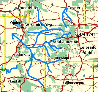
The Peach Springs and Havasu Creek drainages on the west side of the Kaibab Plateau were cut off from the Little Colorado River when it relocated to the east of the rising Kaibab Plateau during the early Oligocene. For a short while they probably flowed north into Utah. However, during early to mid-Miocene time, the Wasatch Range began to rise in Utah - thus blocking the northward route. Starting about 15 million years ago, bits and pieces of the prior drainage systems eventually joined to open a passageway to the Grand Wash Trough at the west end of the Colorado Plateau. (Please see the GCS2000 abstracts for details.) By 12 million years ago, this drainage was complete from Kanab Creek to the Grand Wash Cliffs. (Note: Stream organization was complete long before the Hurricane/Toroweap Faults became active about 3 million years ago. See GCS2000.) For most of the Miocene this drainage system had only a limited amount of water to work with, but this would change very dramatically after the “Grand Canyon” event. A more detailed description of this stream organization will be presented later.
As the Miocene progressed, basin and range stretching systematically destroyed the high mountains southwest of the Mogollion Rim in southwestern Arizona. They literally had the rug pulled out from under them. (See Beus and Morales pages 290 – 305 for details). The Gulf of California was also beginning to open. The combination of these events was preparing an exit route for the Colorado River in advance of the big event.
Further north in Utah, the southern half of the old Uinta Basin continued to rebound. The thousands of feet of sandstone that had accumulated there during the Eocene would gradually be lifted to form the Tavaputs Plateau. The Yampa/Green River however was not about to be dislodged from its course, and it continued digging Desolation Canyon (which is now the deepest canyon in Utah).
In Colorado, the
Colorado River continued to flow across the Uncompahgre
Plateau for most of the period. However, the Uncompahgre was
rising, and the Colorado had to dig ever deeper into Unaweep
Canyon just to maintain its path. Late in the Miocene
but shortly before the Grand Canyon event, it gave up and
found an easier course further north where it currently flows
(more details later). The Gunnison continued flowing through
Unaweep a little longer, and then it also turned northwest to
rejoin the Colorado. (See Roadside Geology of Colorado – page
307) Except for this minor detour, the Colorado would continue
its westward path across Utah to the salt deserts until “the
event”.
It was drier during most of the Miocene, and most of the time the Colorado River would dry up before it could continue north from the Utah deserts to the Snake River (or ancestors of the Salmon). At the same time basin and range stretching was creating new intramountain basins in western and northwestern Utah. The Colorado would fill these in with sediments - including a lot of salt leached out of the old Paradox Basin area.
If we took a picture of the Colorado River Basin about 10 million years ago, it would show low-gradient rivers slowly meandering across broad, mostly flat valleys with the Colorado exiting westward into the Utah deserts. There has been considerable uplift throughout the area since then, but if we express elevations above sea level using the current elevation of Arizona’s ancestral Hopi Lake area as a reference point, we get the following picture. The broad valley was about 5,500 to 6,300 ft. above sea level. In Arizona it was bounded on the east by the Defiance Plateau and Black Mesa. The Mogollon Rim formed the southern boundary while the Kaibab Plateau was a barrier to the west. There were no barriers to the north, and that is where the Little Colorado River continued to flow. (It was dry during the Miocene so there wasn’t much flow. It is entirely possible that much of the time the Little Colorado terminated in the Hopi Lake Basin.)
The broad valley covered most of eastern Utah except for a few isolated buttes and high areas such as the Henry, Abajo, and La Sal Mountains. The Colorado Rockies formed the eastern boundary although many valleys and especially the Yampa and Grand Valleys were part of the broad valley system. The Uintas and the rising Tavaputs Plateau stood out at the northern edge of the valley. River drainage exited the area to the west via the Colorado River. Everything had been peaceful until some10 million years ago when the Colorado started receiving shots across the bow – the Wasatch was rising. (Note: The 10 million years ago date is an estimate. Exact timing is not known.)
While areas west of
the Hurricane/Wasatch/Sevier fault system were dropping, the
Wasatch Ranges were rising east of it. This included the
Colorado River’s exit route, which followed the current path
of highway I-70 from Emigrant Pass, Utah west to Salina, Utah.
(Please see the Wasatch
(Salina) Canyon 3-D map.) Each time the fault system
would slip the Colorado would have to dig a little deeper into
the rising mountains, and at the same time drainage to the
east would have to back up a little more. The climate was
drier than today, but the Colorado wasn’t going to give up
easily. By 5.4 million years ago, the river had dug a canyon
at least 1,000 feet deep across the Wasatch. Today this canyon
is opportunistically occupied by Salina Creek. Interestingly,
Salina Creek starts east of the highest ranges of the Wasatch
and uses this old canyon to bore westward through the
mountains.
The effects on the east side of the rising mountains were just as dramatic. The area east of the Wasatch, which had been undergoing slow erosion up to about 10 million years ago, began to accumulate silt, as the Colorado was too busy trying to keep up with the rising Wasatch. Gradually, the backup would spread east into Colorado and south into Arizona almost to the New Mexico border. The Utah portion received enough silt to keep a lake from forming. In Arizona, there was a mixture of silt and shallow lake deposits (Hopi/Bidahochi Lake). Each time the fault(s) would slip the Wasatch would rise a little higher and everything to the east would back up a little further. The process would continue until the Colorado could find another escape route.
Arizona’s “Hopi Lake” (and Bidahochi Formation) serves as a good reference point for comparing relative elevations during the 11 million-year interval from 16 million years ago to 5 million years ago. Research by Dallegge and others (summarized in the GCS2000 abstracts) indicates the Bidahochi Basin gradually accumulated sediments during this period. More important, the maximum elevation during this time was never higher than about 6,300 feet. (See Hopi Buttes analysis, page 8, GCS2000) Since the Bidahochi is immediately east and southeast of the Kaibab Plateau, the Colorado River could not have been higher than this when it found a path across the Kaibab. This puts a very constrictive restraint on the elevation of the Colorado River when it breached the Kaibab 5.4 million years ago. The break-through elevation was about 6,300 feet above sea level with an error factor of +/- 100 feet.
Some theories on how the Colorado River got across the Plateau require thousands of feet of Mesozoic sediments immediately east of the Kaibab Plateau. This would leave the Kaibab as a relative low point where the river could cross. (Note: If we kept the elevation of the Kaibab static and extrapolate the Kaibab Limestone to directly above the deepest part of the Grand Canyon, this relative low point is 7,700 feet above sea level.) These theories would then require thousands of feet of erosion to remove the Mesozoic deposits, and then leave a broad basin where the Bidahochi sediments could be deposited starting some 16 million years ago. Also, this process would have to leave the current Kaibab Limestone on top of plateau untouched for this extended time period. This sequence appears implausible. The concept of a stable Bidahochi with a maximum elevation of 6,300 feet looks rock solid.
Return to Part 2 - Late Cretaceous through the Eocene
Continue to Part 4 - The Day Before the Grand Canyon Event
Return to Evolution of the Colorado River Main Page
Web page generated via Sea Monkey's Composer HTML editor
within a Linux Cinnamon Mint 18 operating system.
(Goodbye Microsoft)
(Timing was updated on 6/21/04. Before this update, it was assumed that river systems that had been flowing from Colorado northward into Wyoming reversed to flow westward sometime during the Oligocene. Dating from the Bishop Conglomerate (See Harpers Corner) now indicates river patterns shifted about the end of the Oligocene.)
As the Eocene drew to
a close, Utah’s Uinta Basin stopped sinking (and began an
isostatic rebound early in the Miocene). This along with
general uplifts across southern Wyoming and the Rabbit Ears
Range in northern Colorado resulted in major changes in river
systems across eastern Utah and western Colorado at the end of
the Oligocene. (See the Gore Range
section in the appendix for more information on the Rabbit
Ears uplift.) About 20 to 25 million years ago, rivers that
had been flowing north from Colorado into Wyoming were forced
to change direction and flow west into Utah. (See next
illustration) Lake Uinta filled in with silt and
subsequently its southern portion began to rise above the
surrounding terrain about early/mid Miocene time. Basin and
range stretching also began at this time. The immediate impact
of this stretching was to open river exit paths from Utah
northward into Idaho. Late in the Oligocene, Basin and Range
stretching initiated the destruction of the high ground
southwest of Arizona’s Mogollon Rim – setting the stage for
later events. (Note: There is a wide time slot open to these
events, and local delays into the early Miocene would not
upset the relative order.) The timing of the
Wyoming and Colorado uplifts has to be inferred from the
relative order of events in the Uinta Basin / Tavaputs
Plateau area. It is probably safe to assume that river
flow was southwest to northeast across the Uinta Basin
throughout the Eocene. This was when the Green River Formation
was deposited in layers that now top the Tavaputs Plateau.
Sometime after the Eocene, river flow changed direction across
the Uinta Basin. Today, the Green/Yampa River flows southward
through the Tavaputs. The Eocene age Green River Formation is
now 4,000 feet above the river. The only relative order that
seems logical is:1) River flow across the Uinta Basin / Tavaputs was from southwest to northeast.
2) River flow was reversed to NNE to SSW. (The Yampa/Green course is established)
3) The Tavaputs rises, and the Yampa/Green starts digging Desolation Canyon.
We know event 1) belongs to the Eocene. Events 2) and 3) have to be spread over the Oligocene, Miocene, and the 5 million years since the Miocene. All current river paths were in place as of the “Grand Canyon” event 5.4 million years ago (or very shortly thereafter). Thus, most of event 3) has to take place during the Miocene. By a process of elimination, river reversal in all probability has to take place about late Oligocene / early Miocene. (Added 5/21/04: Recent dating evidence shows a 29 million year age for a volcanic ash fall within the Bishop Conglomerate. Deposits of the Bishop Conglomerate at the east end of Dinosaur Monument show that river flow was still west to east at this time. This points to reversal of river flow about 20 to 25 million years ago.)
After timing is in place, we have to use whatever evidence is available to derive the tectonics that caused the shift in river patterns. Hard evidence is only partially available; thus, for the remainder we have to infer what took place.
The Yampa River, which had formerly flowed north from Craig, Colorado into Wyoming, turned west to establish its present course. This new westward course approximated today’s course thru the present highlands of Dinosaur National Monument. (These highlands were still lowlands until they underwent renewed uplift in the last 5 million years. Most of the Eocene deposits extended from Wyoming around the east and south sides of the Uintas and then south to the Tavaputs. The extreme eastern end of the Uinta Mountains had been gradually eroded down to this level and was later covered by the upper layers of the Browns Park Formation.) From the Colorado/Utah border, the new course of the Yampa followed the current path of the Green River to just south of the town of Green River, Utah where it joined the Colorado. (This is the new path for the Colorado, which also relocated about late Oligocene / early Miocene time. See the section on the Colorado River starting two paragraphs down.) It should be noted that the Upper Green River would not join the river system until mid Miocene time. Early in the Miocene the Tavaputs Plateau began to rise, but the Yampa had already established the path that would become Desolation Canyon.
The westward flowing
White and Little Snake Rivers also formed at this time as
tributaries to the Yampa. Just as the Colorado River had to be
in place before the White River Plateau rose (see below), the
White River also had to be in place prior to this uplift. The
White River currently splits the north side of the White River
Plateau with the main part of the plateau to the south and
White (Oak) Ridge to the north. The resulting broad canyon is
over 1,500 feet deep. Big Beaver Creek flows southward into
the plateau just to the east of White (Oak) Ridge to join the
White River. Based on current topography Big Beaver Creek
should have flowed westward just north of the ridge. Instead,
it continues southward through rising strata to cut a canyon
1,000 feet deep before it joins the White River. This requires
Big Beaver Creek to be in place before the White River Plateau
rose. Then as the plateau rose, the stream acted as a
stationary band saw cutting into the rising block.The upper Colorado River, which formerly flowed north from Kremmling, Colorado into Wyoming, found a new route toward the west-southwest. (See the Gore Range sections in the appendix for more information on this change in direction.) When the current Gore Range rose later during the Miocene, the river was in place ready to carve Gore Canyon. Further downstream the river again was ready when the White River Plateau also rose in Miocene time. Glenwood Canyon was the result. (More recent evidence implies most of the Gore Range and White River Plateau uplifts have occurred in the last 5 million years.) The new route for the Colorado then continued west across Utah.
Side Note: The
prevailing assumed age for the uplifts of both the Gore
Range and the White River Plateau assign both to Laramide
time (late Cretaceous – early Tertiary). However, there are
problems with this scenario. We first observe that the south
rim of Glenwood Canyon is over 9,400 feet and the north rim
over 9,800 feet above sea level (uses a linear six mile
distance). The rim rock at these locations is
Mississippi/Pennsylvanian age. If we restore Mesozoic layers
on top of this and hold the strata elevations static since
Laramide time (relative to areas immediately east and west
of the White River Plateau), the altitudes become even
higher. This would make it very difficult for the Colorado
River to find a route across. Even if we assume the Colorado
could use the 9,400-foot elevation, there are problems, as
this would force the entire basin east of Glenwood Canyon to
be higher than 9,400 feet until Glenwood Canyon was carved.
This creates an immediate conflict with the Miocene surface
lava flows a short distance upstream near Gypsum and Eagle,
CO that are found at elevations of 7,000 to 8,000 feet.
Side Note Continued: John Karachewski’s unconformity photo at http://www.geoscapesphotography.com shows a Miocene basaltic flow overlying older strata on the south side of Yarmony Mountain near State Bridge, CO (upstream from Glenwood Canyon). The elevation of the flow is about 7,400 to 7,500 feet. Also of note in the photo, the Miocene lava flow, which would have been level at the time of deposit, now slopes upward toward the northeast. The underlying strata turn up even more steeply to the northeast. Finally, the Gore Range is ten miles northeast of this location. The sequence of events appears to be as follows. The underlying strata were tilted up to the northeast when a low version of the Gore range was uplifted at Laramide time. This was beveled to a near level surface by early Oligocene time. The Colorado turned westward over this beveled range at the end of the Oligocene. The lava flow occurred on a surface that was still level about early Miocene time. Then renewed uplift to the northeast created the current Gore Range. The Colorado was in place and cut Gore Canyon.
Side Note Continued: Finally, if we go upstream from Glenwood Canyon, multiple other exit routes for the Colorado are available under 9,000 feet. The most significant of these would be northward near and east of Muddy Pass (near Rabbit Ears Pass). Here, surface rocks are Cretaceous topped by early Tertiary sediments and mid-Tertiary surface lava flows and still stay under 9,000 feet. This area has never been above 9,000 feet, and thus was always available as a lower alternate route.
Side Note Continued: Any model that assumes the White River Plateau was uplifted in the Laramide and has been static ever since must find an answer to the following question. Why (and how) did the Colorado River pick a route that has never been under 9,400 feet (until recent canyon cutting) when alternate routes have always been available under 9,000 feet? In conclusion, it appears that both the Gore Range and the White River Plateau were exposed (and subject to erosion) at relatively low elevations during the Laramide, but were not lifted to their current relative heights until the Miocene. (More on the Gore Range and the White River Plateau later and in the appendix.)
Further south, the
Gunnison also turned west and met the Colorado River about 15
miles south of the present town of Grand Junction, CO; and
together they crossed the Uncompahgre Plateau at Unaweep
Canyon. (Please see 1st diagram, page 307, Roadside
Geology of Colorado.) The Uncompahge Plateau was much lower at
this time as it had not undergone the major uplift that
started during the Miocene (Roadside Geology of Colorado –
page 264). It is most likely that the exposed surface layer in
the Unaweep area was the easily eroded Mancos Shale, as it
would have provided a convenient low area.At Gateway, CO, the Colorado River was joined by the ancestral San Juan River, which was still flowing north using the present course of the Dolores River. (It should be noted that the southern end of the San Juan was about to change its course leaving just the Dolores as the tributary). The combination continued west to just south of the Tavaputs Plateau.
The ancestral Yampa River joined the new Colorado south of the Tavaputs near the present town of Green River, Utah. From here, the river continued westward establishing a route near and just south of the present highway I-70 until it reached the present location of the salt deserts of western Utah. Then it turned north to join the Snake River (or possibly the northward flowing ancestors of the Salmon River system). Gravel deposits on the North Promontory Mountains straddling highway I-84 in northern Utah may have originated later in the Miocene from this route. (The gravel deposits are shown on page 218, Roadside Geology of Utah, but how they got there is speculative.)
Later in the Miocene, the climate was significantly drier. During these dry periods the river dried up in Utah’s western deserts leaving behind a lot of salt. Basin and range stretching was creating intermountain basins throughout western Utah and these would provide a dumping ground for any silt and salt the river brought in. (20,000 years ago “freshwater” Lake Bonneville occupied much of current Utah, and drained out to the north. The current salt in the Great Salt Lake has leached out from these old deposits.)
Further south, the Oligocene saw volcanic activity break out across southern Utah, northern Arizona, western Colorado and western New Mexico. Volcanic activity included both surface eruptions and underground intrusions. Additionally, several local uplifts started, with this activity continuing into the Miocene. Several of these uplifts were near the Four Corners area including New Mexico’s Chuska Mountains, and a large area stretching from Colorado’s La Plata Mountains to Utah’s Abajo Mountains. (These intrusions and uplift were the result of “an essentially continuous, intracontinental magmatic zone extending from Reno to the San Juan Mountains during the Oligocene and early Miocene.” http://geology.cr.usgs.gov/pub/bulletins/b2158/B2158-4.pdf)
The regional uplift
extending from the Abajos and La Platas (and to a diminishing
degree southward toward New Mexico) would change the course of
the San Juan River about late Oligocene to early Miocene time.
(This time period is an estimate based on widespread volcanic
activity that broke out in the western San Juan Mountains
between 25 and 30 million years ago. (Field Trip Guidebook -
page 24)) (Note: The igneous intrusions in the La Plata
Mountains around the K-T boundary time produced local uplifts,
but these uplifts were only local in geographic area. The
Oligocene/Miocene renewed uplift extended over a much larger
area.)When the Abajo and La Plata Mountains (and nearby terrain) underwent renewed uplift, the San Juan River which had flowed west-northwest just to the south of the Durango area was diverted further south into New Mexico. Then, from northwestern New Mexico the easiest route for the San Juan River to get to the former Lake Uinta lowlands was to travel westward in-between Arizona’s Defiance Plateau and Utah’s Monument Upwarp. Thus, the new path for the San Juan was reset southward to Farmington, NM and thence west to near the eastern end of Lake Powell. (Of note: West of Mexican Hat, Utah this route was south of the current Goosenecks/San Juan Canyon area.) There it could turn north, and after joining the Little Colorado the combination flowed north to eventually join the Colorado. The old path of the San Juan from McPhee Reservoir north would still be used by one of its tributaries – the Dolores, and this portion is still called the Dolores River today. (See the Appendix for more details.)
In northern Arizona, the late Eocene / early Oligocene renewed uplift of the Kaibab Plateau forced a relocation of the Little Colorado River. (See bottom of page 56, Fission-Track Dating GCS2000 abstracts regarding this date. However, we disagree with the hypothesis that the ancestral Colorado River was at this locality at the time.)
The climate was turning drier, and this time the reduced flow of the Little Colorado River was not able to cut down fast enough to maintain its old course across the Kaibab. (Alternately, by the Oligocene the Little Colorado’s downstream gradient was less steep (which would have reduced erosive power), and this might have been the reason the Little Colorado couldn’t maintain its path across the Kaibab.) In any case, the Little Colorado relocated to the east of the Kaibab Plateau. However, the paleocanyon that the river had carved across the plateau would remain as a low spot. (Note: This old canyon was in early Mesozoic sediments directly above the Kaibab Plateau portion of the current Grand Canyon. These old layers have since worn away. Also note: Even after the uplift, all the strata layers were still at least 1,400 feet lower than they are today.) This ancestral canyon would be dry and have no influence on river patterns for the next 30 million years – and then it would roar back to life.
The Little Colorado’s
new path north from Cameron, AZ is unknown but one possibility
would be north to “The Gap”, then northeast to Kaibito, and
thence northward slightly to the west of Navajo Mountain.
(This path is a somewhat speculative “guesstimate”, but the
assumption is the Little Colorado would try to stay east of
the Echo Cliffs Monocline.) Then from the current Lake Powell
area, the river would continue northeastward to the east of
the Henry Mountains and then north-northwest to the Colorado
River. This area has been heavily eroded in the last 5.4
million years and it is unlikely that there is any evidence
left from this former path. However, high altitude and
satellite photos show south-southwest to north-northeast
streaks near and to the west of Kaibito that may be remnants
of the old path.(The source of the “Streaks” is unknown. They could be the result of recent wind erosion, left over gravel that protects portions of the surface, combinations of these, or something else. However, detailed topographic maps eliminate recent water erosion. Horse Thief Mesa (7 mi. WNW of Kaibito) shares this SSW to NNE orientation. Most other topographic features in this area have a SSE to NNW grain. You can view these features by going to: http://terraserver.microsoft.com , key in Kaibito for the location, click on Aerial Photograph, click on large image size, and pan westward.)
Another possible path for the Little Colorado would take it some 30 miles further eastward. This potential course would turn northeast from Cameron to the western edge of Black Mesa, then northward just to the east of Navajo Mountain, and continue northward just to the east of the Henry Mountains. This scenario would account for the gravel deposits on the west side of Black Mesa. Navajo Creek and some of its southwestern tributaries (originate just northeast of state highway 98) appear to have inherited an ancestral SSW to NNE drainage system, which would support this potential path.
Miocene (About 23 to 5 million years ago)
There were several
significant changes in river patterns during the Miocene. The
first of these occurred in the Green River Basin in
southwestern Wyoming. The second was organization of the
ancestral Hualapai drainage on the west side of the Kaibab
Plateau. Then everything was ready for the dramatic Grand
Canyon event that took place about 5.4 million years ago.In late Oligocene time, river drainage out of the Green River Basin had been northeastward approximately following Wyoming highway route 28. Early Miocene sediments can be found at 7,500 – 8,000 feet above sea level to the southwest and west of South Pass City. These were probably deposited about or shortly before the renewed uplift of the Wind River Range between 25 and 15 MYA. (See Geo. Soc. of Am. Bulletin 103,472-485, 1991)
The current Sweetwater River appears to contain a segment of this old drainage route. The Sweetwater originates on the southwest side of the Wind River Mountains, and initially flows south and southwest toward the Green River Basin. Then it ignores current topography and turns eastward around the south end of the “Windies”. This eastward flowing section appears to be a segment of the route the ancestral Green River used before it was deflected southward.
When the Wind River
Range underwent renewed uplift, drainage from the Green River
Basin was forced to find a new outlet. The new outlet for the
basin formed at the southeast end. The Green would flow south
through the basin until it was blocked by the Uintas. Then it
turned southeast until it joined the Yampa. The last portion
of this route is somewhat uncertain, but a good guess would
place the juncture east of the Dinosaur National Monument
area. The Peach Springs and Havasu Creek drainages on the west side of the Kaibab Plateau were cut off from the Little Colorado River when it relocated to the east of the rising Kaibab Plateau during the early Oligocene. For a short while they probably flowed north into Utah. However, during early to mid-Miocene time, the Wasatch Range began to rise in Utah - thus blocking the northward route. Starting about 15 million years ago, bits and pieces of the prior drainage systems eventually joined to open a passageway to the Grand Wash Trough at the west end of the Colorado Plateau. (Please see the GCS2000 abstracts for details.) By 12 million years ago, this drainage was complete from Kanab Creek to the Grand Wash Cliffs. (Note: Stream organization was complete long before the Hurricane/Toroweap Faults became active about 3 million years ago. See GCS2000.) For most of the Miocene this drainage system had only a limited amount of water to work with, but this would change very dramatically after the “Grand Canyon” event. A more detailed description of this stream organization will be presented later.
As the Miocene progressed, basin and range stretching systematically destroyed the high mountains southwest of the Mogollion Rim in southwestern Arizona. They literally had the rug pulled out from under them. (See Beus and Morales pages 290 – 305 for details). The Gulf of California was also beginning to open. The combination of these events was preparing an exit route for the Colorado River in advance of the big event.
Further north in Utah, the southern half of the old Uinta Basin continued to rebound. The thousands of feet of sandstone that had accumulated there during the Eocene would gradually be lifted to form the Tavaputs Plateau. The Yampa/Green River however was not about to be dislodged from its course, and it continued digging Desolation Canyon (which is now the deepest canyon in Utah).
In Colorado, the
Colorado River continued to flow across the Uncompahgre
Plateau for most of the period. However, the Uncompahgre was
rising, and the Colorado had to dig ever deeper into Unaweep
Canyon just to maintain its path. Late in the Miocene
but shortly before the Grand Canyon event, it gave up and
found an easier course further north where it currently flows
(more details later). The Gunnison continued flowing through
Unaweep a little longer, and then it also turned northwest to
rejoin the Colorado. (See Roadside Geology of Colorado – page
307) Except for this minor detour, the Colorado would continue
its westward path across Utah to the salt deserts until “the
event”.It was drier during most of the Miocene, and most of the time the Colorado River would dry up before it could continue north from the Utah deserts to the Snake River (or ancestors of the Salmon). At the same time basin and range stretching was creating new intramountain basins in western and northwestern Utah. The Colorado would fill these in with sediments - including a lot of salt leached out of the old Paradox Basin area.
If we took a picture of the Colorado River Basin about 10 million years ago, it would show low-gradient rivers slowly meandering across broad, mostly flat valleys with the Colorado exiting westward into the Utah deserts. There has been considerable uplift throughout the area since then, but if we express elevations above sea level using the current elevation of Arizona’s ancestral Hopi Lake area as a reference point, we get the following picture. The broad valley was about 5,500 to 6,300 ft. above sea level. In Arizona it was bounded on the east by the Defiance Plateau and Black Mesa. The Mogollon Rim formed the southern boundary while the Kaibab Plateau was a barrier to the west. There were no barriers to the north, and that is where the Little Colorado River continued to flow. (It was dry during the Miocene so there wasn’t much flow. It is entirely possible that much of the time the Little Colorado terminated in the Hopi Lake Basin.)
The broad valley covered most of eastern Utah except for a few isolated buttes and high areas such as the Henry, Abajo, and La Sal Mountains. The Colorado Rockies formed the eastern boundary although many valleys and especially the Yampa and Grand Valleys were part of the broad valley system. The Uintas and the rising Tavaputs Plateau stood out at the northern edge of the valley. River drainage exited the area to the west via the Colorado River. Everything had been peaceful until some10 million years ago when the Colorado started receiving shots across the bow – the Wasatch was rising. (Note: The 10 million years ago date is an estimate. Exact timing is not known.)
While areas west of
the Hurricane/Wasatch/Sevier fault system were dropping, the
Wasatch Ranges were rising east of it. This included the
Colorado River’s exit route, which followed the current path
of highway I-70 from Emigrant Pass, Utah west to Salina, Utah.
(Please see the Wasatch
(Salina) Canyon 3-D map.) Each time the fault system
would slip the Colorado would have to dig a little deeper into
the rising mountains, and at the same time drainage to the
east would have to back up a little more. The climate was
drier than today, but the Colorado wasn’t going to give up
easily. By 5.4 million years ago, the river had dug a canyon
at least 1,000 feet deep across the Wasatch. Today this canyon
is opportunistically occupied by Salina Creek. Interestingly,
Salina Creek starts east of the highest ranges of the Wasatch
and uses this old canyon to bore westward through the
mountains.The effects on the east side of the rising mountains were just as dramatic. The area east of the Wasatch, which had been undergoing slow erosion up to about 10 million years ago, began to accumulate silt, as the Colorado was too busy trying to keep up with the rising Wasatch. Gradually, the backup would spread east into Colorado and south into Arizona almost to the New Mexico border. The Utah portion received enough silt to keep a lake from forming. In Arizona, there was a mixture of silt and shallow lake deposits (Hopi/Bidahochi Lake). Each time the fault(s) would slip the Wasatch would rise a little higher and everything to the east would back up a little further. The process would continue until the Colorado could find another escape route.
Arizona’s “Hopi Lake” (and Bidahochi Formation) serves as a good reference point for comparing relative elevations during the 11 million-year interval from 16 million years ago to 5 million years ago. Research by Dallegge and others (summarized in the GCS2000 abstracts) indicates the Bidahochi Basin gradually accumulated sediments during this period. More important, the maximum elevation during this time was never higher than about 6,300 feet. (See Hopi Buttes analysis, page 8, GCS2000) Since the Bidahochi is immediately east and southeast of the Kaibab Plateau, the Colorado River could not have been higher than this when it found a path across the Kaibab. This puts a very constrictive restraint on the elevation of the Colorado River when it breached the Kaibab 5.4 million years ago. The break-through elevation was about 6,300 feet above sea level with an error factor of +/- 100 feet.
Some theories on how the Colorado River got across the Plateau require thousands of feet of Mesozoic sediments immediately east of the Kaibab Plateau. This would leave the Kaibab as a relative low point where the river could cross. (Note: If we kept the elevation of the Kaibab static and extrapolate the Kaibab Limestone to directly above the deepest part of the Grand Canyon, this relative low point is 7,700 feet above sea level.) These theories would then require thousands of feet of erosion to remove the Mesozoic deposits, and then leave a broad basin where the Bidahochi sediments could be deposited starting some 16 million years ago. Also, this process would have to leave the current Kaibab Limestone on top of plateau untouched for this extended time period. This sequence appears implausible. The concept of a stable Bidahochi with a maximum elevation of 6,300 feet looks rock solid.
Return to Part 2 - Late Cretaceous through the Eocene
Continue to Part 4 - The Day Before the Grand Canyon Event
Return to Evolution of the Colorado River Main Page
Web page generated via Sea Monkey's Composer HTML editor
within a Linux Cinnamon Mint 18 operating system.
(Goodbye Microsoft)