
Durango Bill's
Paleogeography (Historical Geology) Research
Formation and Origin of Desolation / Gray Canyon, Utah
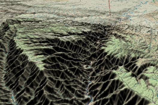 This view of the main part of
Desolation Canyon shows the full, nearly 5,000-ft. depth of
the canyon. Here in the deepest part of the canyon, the Roan
Cliffs (early Tertiary deposits) flank both sides and rise to
over 9,000 feet above sea level. The Green River flows from
north to south through the canyon. The Yampa River originally
established this path some 20 - 25 million years ago with the
Green River joining the system sometime in mid/late Miocene
time. Contour lines are at 100-foot intervals.
This view of the main part of
Desolation Canyon shows the full, nearly 5,000-ft. depth of
the canyon. Here in the deepest part of the canyon, the Roan
Cliffs (early Tertiary deposits) flank both sides and rise to
over 9,000 feet above sea level. The Green River flows from
north to south through the canyon. The Yampa River originally
established this path some 20 - 25 million years ago with the
Green River joining the system sometime in mid/late Miocene
time. Contour lines are at 100-foot intervals.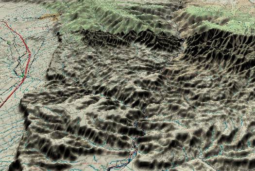 The second picture features the
Gray Canyon portion where the Green River continues its
southward path through the center of the picture. The Roan
Cliffs are in the distance with a slight overlap for the two
pictures. Of interest, the Price River enters from the left
edge and joins the Green near the center of the picture. In
the process, it ignores an easy, lower route around the
southwest side of the Book Cliffs, and instead, cuts into
Cretaceous age strata en route to its confluence with the
Green River.
The second picture features the
Gray Canyon portion where the Green River continues its
southward path through the center of the picture. The Roan
Cliffs are in the distance with a slight overlap for the two
pictures. Of interest, the Price River enters from the left
edge and joins the Green near the center of the picture. In
the process, it ignores an easy, lower route around the
southwest side of the Book Cliffs, and instead, cuts into
Cretaceous age strata en route to its confluence with the
Green River. The Book Cliffs form the exposed edge of the Mesa Verde Group. (Sedimentary layers that were deposited during the Cretaceous.) Since the strata dip down to the north, these layers are still buried further north. The main part of the Tavaputs Plateau (Roan Cliffs and Desolation Canyon) is much more significant as it contains 4,000 feet of sandstone (Wasatch Formation) and shale (Green River Formation) that were deposited during the first half of the Tertiary. The Green River Formation contains immense quantities of kerogen (“oil shale”). At one time it was thought that this kerogen could be economically processed into a synthetic crude oil. However, it is looking increasingly unlikely that any process will ever be found that can produce a positive energy return on energy investment. The Green River Formation is also famous for fish fossils.
The Tavaputs Plateau is of major importance in determining the sequence of events and placing time constraints on the evolution of the Colorado River. The relative order of events is:
1) 4,000 feet of sediments were deposited in an ancient basin by river systems flowing from south to north. These sediments now form the Roan Cliffs (uppermost 4,000 feet of the plateau), and were derived from erosion in northern Arizona and the western slopes of the newly risen Rocky Mountains.
2) River drainage reversed direction to flow from north-northeast to south-southwest. Initially, this was just the Yampa River, with the Green River joining the system later. The Yampa is now defined as a tributary to the Green (but theoretically this could be vice versa).
3) The plateau rose and the river played the part of a stationary band saw and cut the canyon.
We know event 1) occurred during the first half of the Tertiary. (Paleocene, Eocene, and Oligocene). Events 2) and most of 3) are thus forced into the Miocene. The Bishop Conglomerate in Dinosaur National Monument indicates the reversal in river drainage took place about 20 - 25 million years ago. At least one-half of event 3) is estimated to have been completed by the time of the Grand Canyon event about 5.4 million years ago. This leads to the following chronology for the Tavaputs Plateau and Desolation Canyon.
In the first half of the Tertiary (65 to about 25 million years ago) river drainage was from south to north in this area. The ancestral Little Colorado River flowed northward from the west side of the Kaibab Plateau, to the present Wasatch Plateau, and then turned northeastward to the Tavaputs / Uinta Basin area. Most of the sediments that are in the Roan Cliffs portion of the plateau were brought in by the ancestral San Juan River, which flowed north from southwestern Colorado, and joined the ancestral Little Colorado near the present location of the Tavaputs. The San Juan has since relocated further south, but the old path is still used by the Dolores River. About 40 million years ago, the ancestral Little Colorado abandoned its initial route across the Kaibab Plateau, but continued to flow northward to the east of the Kaibab.
About 20 to 25 million years ago, uplifts in northern Colorado and southern Wyoming forced a change in river patterns. The ancestral Colorado River, which had been flowing from northern Colorado into Wyoming, found a new route westward across Utah. Its path was just off the lower edge of the picture. The Yampa River also developed west and then southwest to join the Colorado River just south of the present town of Green River. (Off the lower edge of the picture) This is the same path the Green River uses in Desolation Canyon today.
During the mid/late Miocene, the Tavaputs Plateau began its uplift as the south side of the old Uinta Basin began to rise. The Yampa River was in place and started cutting Desolation Canyon. About the same time the Wind River Range in Wyoming underwent renewed uplift which forced the Green River to turn south to join the Yampa.
By 10 million years ago the Tavaputs Plateau had risen high enough so that the canyon had cut down to near the top of the present Book Cliffs. The Wasatch Ranges further west in Utah were also rising, thus creating a barrier to the Colorado River, which tried to maintain its old course into western Utah.
By 5.4 million years ago a large, flat silt backup system extended eastward from the Colorado River's bottleneck in the rising Wasatch Ranges. The flat surface slightly covered the Book Cliffs. The Green River was confined to where it had already cut several thousand feet deep into the rising Tavaputs Plateau, but the Price River was free to wander randomly across the silt flats.
5.4 million years ago the Colorado River found an escape route through an ancestral canyon across the Kaibab Plateau and started to dig the Grand Canyon. This lowered the erosion surface level for the whole river system, and canyon cutting in the Colorado and all its tributary rivers worked rapidly back upstream. When canyon cutting worked back up to the Price River, it became entrenched in its current path.
If we look at the 2nd picture, we note that a broad valley has been excavated to the west of the Book Cliffs. (Also to the south off the lower edge of the picture) This zone is where the Mancos Shale layer intersects the surface. Shale is a soft, easily crumbled, non-porous rock. Since it is not porous, water does not soak in and plants have a difficult time growing on it. Without a vegetation surface to protect it from desert thunderstorms or the extreme day to night temperature variations and the associated thermal expansion and contraction, shale is an easy prey to ordinary erosion. Thus, a broad area has eroded away to produce the present topography.
Return to the Image Index page
Web page generated via Sea Monkey's Composer HTML editor
within a Linux Cinnamon Mint 18 operating system.
(Goodbye Microsoft)