
Gore Canyon, Colorado
Origin and Formation of Gore Canyon, Colorado
The Chronology on how the Colorado River formed Gore Canyon
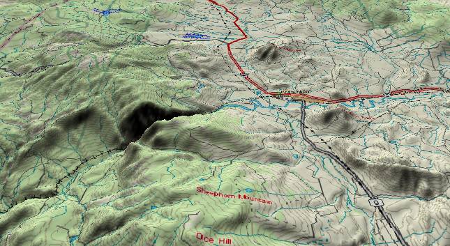
View to the north
showing Gore Canyon where the Colorado River cuts east to west
through the Gore Range. Contour lines at 100-foot
intervals. Kremmling, Colorado is to the right (east) of
the canyon. Also, an abandoned high valley cuts east to west
through the range just south of the canyon. The valley was
originally cut by the Blue River (which currently flows
northward from the lower right edge), but the Blue gave up on
this route and now continues north to join the Colorado just
to the east of the canyon.
In theory the Colorado River could take an easier route following the valley to the north - staying east of the Gore Range. Ultimately it would go over Muddy Pass which is currently 600 feet lower than the rims of Gore Canyon. How and why did the river take this seemingly more difficult route through the Gore Range?
There appear to be two separate Gore Ranges as we go back in time. The first range rose during the Laramide mountain building period some 65 to 70 million years ago. The ancestor of the Colorado River stayed east of the original Gore Range and flowed northward from Kremmling into Wyoming. During the Paleocene and Eocene this original Gore Range eroded down to a nearly flat surface. Then the Rabbit Ears Range (northeast of here) rose during the Oligocene blocking the old northward drainage.
The river turned west-southwest to its present course. The Blue River also turned west and joined the Colorado at the west end of the present canyon. Then, the major uplift of the current Gore Range started during the Miocene. It is probable the Gore Range is still rising today. As the Gore Range rose, both rivers tried to maintain their established routes by cutting downward. Bedrock in the Gore Range is very hard Precambrian gneiss and schist. The Blue River didn't have the cutting power of the Colorado and its down cutting gradually lagged behind that of the Colorado. The northwest to southeast valley to the right (east) of the range has much softer Tertiary and late Cretaceous deposits that erode easily under ordinary weathering. Eventually the Blue River abandoned the old high valley and relocated to its present location to join the Colorado east of the canyon.
Also, please see http://www.durangobill.com/PaleoAppendPart7.html
Return to the Image Index Page
Web page generated via Sea Monkey's Composer HTML editor
within a Linux Cinnamon Mint 18 operating system.
(Goodbye Microsoft)