
Durango Bill's
Paleogeography (Historical Geology) Research
Salina (Wasatch) Canyon, Utah
View to the west
with contour intervals at 100 feet. Highway I-70 uses this
breach across Utah's Wasatch Plateau. Surface layers are
mostly the Mesa Verde Group, and many faults cut north to
south (right to left) across the area as part of the
Sevier/Wasatch Fault system.
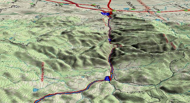
Salina Creek flows
east to west (foreground to background) through this breach
point now, but it is just a local stream opportunistically
using a route pioneered by the Colorado River. As shown by the
flattish areas in the foreground and middle background, Salina
Creek currently has little cutting power.
The Colorado River developed a westward route through this area when uplifts near the end of the Oligocene in Colorado's Rabbit Ears Range and across southern Wyoming blocked earlier drainage northward into Wyoming. The river stayed here until about 5.4 million years ago.
During the Miocene, basin and range stretching was opening evaporative basins in western Utah. Since the climate was even drier than it is now, the ancestral Colorado evaporated leaving a lot of silt and salt as sediments. The source of the salt was what the upstream portions of the river leached out of Paradox Basin (in southeast Utah/southwest Colorado). Today, the Humboldt River in northern Nevada is a model for what the Colorado River was like in early to mid Miocene time.
The Wasatch Ranges started rising during the Miocene and by 10 million years ago started to obstruct the Colorado's old route into western Utah. As the ranges rose, the river had an increasingly difficult time maintaining its old path, and a massive backup system formed east of here. Silt deposits backed up into northwest Colorado (the Browns Park Formation) and extended southward across the Hopi Lake / Bidahochi area in eastern Arizona. About 5.4 million years ago, the backup system overflowed the Kaibab Plateau at the present location of the Grand Canyon. The Colorado River abandoned this route across the Wasatch and started digging the Grand Canyon. However, local drainage within the rising Wasatch could still feed into this old breach point.
20,000 years ago, large areas of western Utah were part of freshwater Lake Bonneville, but subsequently the climate has become drier, and the lake has shrunk to the current Great Salt Lake. Salt in the lake as well as the surface salt layers in Utah’s western deserts has leached out of the sediments that were left behind in the basins.
Return to the Image Index Page
Web page generated via Sea Monkey's Composer HTML editor
within a Linux Cinnamon Mint 18 operating system.
(Goodbye Microsoft)