
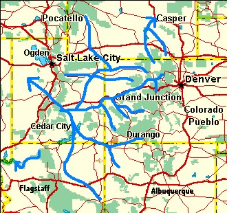
Durango Bill's
Paleogeography (Historical Geology) Research
Evolution of the Colorado River and its Tributaries
by
Bill Butler
Evolution of the Colorado River and its Tributaries
including Formation and Origin of the Grand Canyon
Geologic History of the Grand Canyon
Part 4 – The day Before the Grand Canyon Event – A Tour Around the Flat Valley
 It’s worthwhile to go
back to the day of the event some 5.4 million years ago, and
then go back one day further to see what the situation looked
like. For thousands of individual lurches spread over millions
of years, the Wasatch had
been rising. Sometimes when the fault(s) would slip, the
Wasatch would rise only a few inches while a big lurch might
add a couple of feet. A few million years earlier the Colorado
only had to erode through the crest of the rising mountains to
continue its path to the west. Over the next few million years
it had to slice a canyon at least 1,000 ft. deep into the
rising mass just to maintain its path. Worse yet, as the range
rose, the distance across the range that it had to erode grew
increasingly wider. By the day before the event, this extra
width extended some fifteen to twenty miles to the
east-southeast of the crest.
It’s worthwhile to go
back to the day of the event some 5.4 million years ago, and
then go back one day further to see what the situation looked
like. For thousands of individual lurches spread over millions
of years, the Wasatch had
been rising. Sometimes when the fault(s) would slip, the
Wasatch would rise only a few inches while a big lurch might
add a couple of feet. A few million years earlier the Colorado
only had to erode through the crest of the rising mountains to
continue its path to the west. Over the next few million years
it had to slice a canyon at least 1,000 ft. deep into the
rising mass just to maintain its path. Worse yet, as the range
rose, the distance across the range that it had to erode grew
increasingly wider. By the day before the event, this extra
width extended some fifteen to twenty miles to the
east-southeast of the crest.The Day Before – Wasatch (Salina) Canyon
On the east side of the breach, the Colorado had to start digging in the foothills near the present location of Emigrant Pass (on highway I-70 in Utah) before continuing westward across the crest of the Wasatch. Today, Salina Creek opportunistically uses this old breach point. However, it seems highly probable that the ancestral Colorado River was the only force capable of carving a path across the rising mountain range. (See the picture on the Salina Canyon page. You can access it via the link on the Image Index page.)
A stream deposit may exist for this old river course. A map on page 116 “Roadside Geology of Utah” shows a small “Quaternary” deposit on the east side of Johns Peak at the 8,400 – 8,600 ft. level about 6 miles southeast of Emigrant Pass. There are no mountain streams near this location and Johns Peak (the highest nearby mountain and only 9,500 ft.) does not appear to be high enough to support Pleistocene glaciers. It is quite possible that this deposit is a remnant of the former riverbed just before the river shifted course. (This should be verified by someone familiar with the area). If we use the maximum current elevation of the Bidahochi sediments in Arizona as a stable reference point (estimated at 6,300 ft. above sea level), then this gravel deposit would also have to be about 6,300 feet above sea level 5.4 million years ago. This yields a further uplift of the Wasatch of about 2,200 feet since the event. (It should be noted that 5.4 million years ago the entire Colorado Plateau / Rocky Mountain area was much lower).
The Day Before – The Flat Valley
To the east of Emigrant Pass a large, flat, silt-covered valley spread across Utah, bounded by the Rockies on the east and the Tavaputs Plateau (which had risen 2 to 3 thousand feet above the valley) at the north end. Another section of the broad valley extended from the north side of the Tavaputs Plateau northeast into Colorado. South of the Tavaputs Plateau the valley extended southward across silt flats into northern Arizona and then across Hopi (Bidahochi) Lake to near the New Mexico border. It was underlain by an old flat eroded surface. The surface elevation though out this area was around 6,300 feet but slightly higher to the east as this was the source area for sediments.
The Day Before – The San Rafael Swell
The San Rafael Swell
is immediately east of Emigrant Pass. The top of the swell is
relatively flat as would be expected of the old valley floor
before it was covered with silt. However, it is currently
7,000 feet above sea level - which at first seems too high for
the old plain. Clues to its history are provided by Muddy
Creek and the San Rafael Rivers. At the south end of the
swell, Muddy Creek runs topographically uphill over terrain
that would be 6,500 to 7,000 ft. above sea level if recent
canyon erosion were restored. The San Rafael River climbs
topographically to a similar altitude over the north end.
(Other arroyos exhibit similar phenomena.) It is logical to
conclude that 5.4 million years ago, the San Rafael Swell was
500 to1,000 feet less elevated (relative to terrain east of
it) than it is now. If we assume that it has been uplifted in
the interim, then the silt plain could cover it, and the two
streams could subsequently establish their present courses
while ignoring the underlying contours.The Day Before – The Price River
Further north, the current course of the Price River also cuts across the San Rafael Swell. Of more interest it continues east-southeast through the Book Cliffs to where it joins the Green River. (If it followed present topography, the Price would take a much easier route further south around the Book Cliffs. However, 5.4 million years ago the Book Cliffs hadn’t been exposed yet.) The Book Cliffs in this area top out at about 6,800 feet. For the Price River to go through this area, the eroded valley floor plus the silt covering had to be about 6,300 feet above sea level. Current stream flow of the Green River through Desolation Canyon implies the area is slowly rising; thus, the lower elevation in the past seems reasonable. The Price River, like everything else in the large silt filled valley, would have meandered almost randomly across the silt flats. When canyon cutting would subsequently take over, the river happened to be on top of what would become the Book Cliffs. Furthermore, it should have had meanders typical of anything flowing across a silt plain. Thus, when canyon cutting finally was established, one would expect that the embedded meanders would still be there. This expectation is confirmed when one takes a close look at detailed maps of the area.
The area immediately south of the Book Cliffs would have had the same flat elevation of 6,300 ft. above sea level. Currently the area is mostly between 4,500 and 4,700 feet. Any evidence of the ancestral Colorado River’s path across Utah south of the Book Cliffs along with another 1,500 feet of the valley floor has since been removed by erosion.
The Day Before – Split Mountain and Canyon of Lodore
There was an extension
of the flat valley extending north from the Tavaputs Plateau.
At the northeast end of this extension one reaches the current
location of Split
Mountain and the highlands of Dinosaur National Monument.
The Green and Yampa Rivers obviously cut down into this area,
but the mechanics and timing have been somewhat of a mystery.
Topographic maps show the old flat surface is 7,500 to 8,000
feet above sea level in the Dinosaur/Lodore area. This is a
hint as to how the meandering river ended up on top of Split
Mountain and then cut down through it. A logical explanation
is as follows.Some 10 million years ago, the Dinosaur/Lodore area was some 1,500 to 2,000 feet lower than at present. (If it were not, the Wyoming portion of the Green River would have found an easier exit route either to the east toward the North Platte River, or to the west toward the Bear River.) A few miles further to the northeast, the Green River traveled northwest to southeast through the Browns Park area, which was stratigraphically 500 to 800 feet higher than it is today. The Green joined the Yampa near Cross Mountain. (This is about 40 miles east of the current junction). The area was mostly flat but low hills extended southeastward from the Lodore area toward the present Dinosaur highlands. Higher elevations of the Uintas prevailed further to the west. When the silt plain backed up into this area almost everything was covered by silt brought in by the Green and Yampa Rivers. These silt deposits would become the Browns Park Formation. The silt flats extended eastward up the Yampa Valley to Steamboat Springs, and buried Cross Mountain, Juniper Mountains, and Signal Butte in the process.
After the Colorado River overflowed the Kaibab Plateau 5.4 million years ago, the Green River would find the westernmost (shortest) possible path to the southwest. This is now the same course it takes through the Canyon of Lodore, but 5.4 million years ago it was a flat silt plain broken by a few low hills.
The paths of these two rivers continued to meander randomly across the silt flats for a hundred thousand years or so after the Colorado River overflowed across the Kaibab. However, as the Colorado began to excavate the Grand Canyon the exit elevation for the flat valley was lowered thus allowing canyon cutting to work its way back upstream. Eventually this would include the Lodore/Dinosaur area. The two rivers became entrenched as they cut lower into the Browns Park and old Eocene deposits. The random course that the Green had set earlier turned out to be directly above Split Mountain. Canyon cutting was enhanced as the Lodore/Dinosaur area began rising some 5 million years ago. Finally, the Browns Park area started to sink, but the Green River was entrenched by now. Thus it continued its course south-southwest across the eastern end of the Uintas and steadily deepened the Canyon of Lodore.
Remnants of all the old geologic landmarks can still be found. To the northeast of Browns Park, surface rocks are still the old Eocene deposits. When Browns Park sank, it took the “back-up” silt down with it. This protected it from significant further erosion as the Green River was spending most of its effort carving the Canyon of Lodore. The area east of the Browns Park / Dinosaur area has also preserved a lot of the Browns Park silt formation (even though it has had little change in elevation) as the rising Dinosaur highlands protected it. The old random wanderings of the Yampa ended up over portions of Cross and Juniper Mountains, and subsequent downcutting formed small canyons through them. Also, the meanders of the Yampa ended up over Signal Butte where they are now entrenched
On the actual uplifted highlands most (but not all) of the Browns Park Silt has been eroded away. Finally, to the south of the Canyon of Lodore, portions of the old flat valley (before silt back up) can still be found on Diamond Mountain to the north of Split Mountain, and on Blue Mountain Plateau to the southeast. (See Lodore and Harpers Corner)
The Day Before – The La Sal Mountains
 The Colorado River
currently cuts through the northwest edge of the La Sal
Mountains in extreme eastern Utah near the Colorado border.
Based on current topography it would be much easier to get to
the Moab area if the river went somewhat northwest of where it
is now. However, 5.4 million years ago the silt flats covered
the northwest side of the La Sal Mountains and that’s where
the river happened to be when canyon cutting caught up with
it. The area extending northwest from the river’s path in the
La Sal Mountains to the Book Cliffs has subsequently eroded
downward some 1,500 feet. The flat surface across this area is
a result of periodic desert cloudbursts washing away Mancos
Shale until it was eroded down to (or near) the Dakota
Sandstone.
The Colorado River
currently cuts through the northwest edge of the La Sal
Mountains in extreme eastern Utah near the Colorado border.
Based on current topography it would be much easier to get to
the Moab area if the river went somewhat northwest of where it
is now. However, 5.4 million years ago the silt flats covered
the northwest side of the La Sal Mountains and that’s where
the river happened to be when canyon cutting caught up with
it. The area extending northwest from the river’s path in the
La Sal Mountains to the Book Cliffs has subsequently eroded
downward some 1,500 feet. The flat surface across this area is
a result of periodic desert cloudbursts washing away Mancos
Shale until it was eroded down to (or near) the Dakota
Sandstone.The Day Before – Unaweep Canyon
A few dozen miles northeast of the La Sal Mountains, one finds Unaweep Canyon. Today, this is a dry canyon that mysteriously cuts across the Uncompahgre Plateau; but it is obvious that at sometime in the past, a large river flowing from east-northeast to west-southwest cut this canyon. Most of the action at Unaweep took place before the Grand Canyon event 5.4 million years ago, but it is an interesting story in any case.
When Colorado’s Rabbit Ears Range began rising about late Oligocene time (also a general uplift across southern Wyoming), the earlier drainage that had been going north from Kremmling, Colorado turned west toward Utah. This gave birth to the Colorado River. The southern portion of the Uinta Basin also started to rise early in the Miocene, which forced the new Colorado River to trend west-southwestward. This west-southwest course extended over what is now the north end of the Uncompahgre Plateau. The Uncompahgre currently rises to over 9,000 feet above sea level in the Unaweep area. Since the Colorado River couldn’t have run uphill, the Uncompahgre had to be thousands of feet lower during the Oligocene. (Also, see Roadside Geology of Colorado, page 264.)
The Uncompahgre Plateau then rose thousands of feet during the Miocene. The Colorado had established its course and followed the standard canyon cutting routine into the rising plateau. Subsequently, we know that it abandoned the canyon, but it takes a bit of detective work to find out when and why.
First, we note that high point at Unaweep Divide within Unaweep Canyon is about 7,000 feet above sea level with both sides sloping very gradually downward. Given that the downslope to the west is very gradual for the first few miles, we know the Colorado abandoned this route BEFORE canyon cutting from the Grand Canyon event had backed up to this area. (If it hadn’t abandoned this route by then, the river would have had an easy time slicing down the west side of the Uncompahgre and there would probably be a much deeper canyon and another national park here).
Some 15 miles north of Unaweep Canyon, there are remnants of the old flat valley at the 6,500 to 7,000 foot level in Glade Park (southwest of Colorado National Monument). If we compare this elevation with the high saddle point in the canyon, we note there is only a few hundred feet difference.
Next, we observe that the Dakota Sandstone once capped the Uncamphagre (it still exists over large areas on the northeast side) and the next layer up would have been the easily eroded Mancos Shale. Finally, if we check the axis of the Uncompahgre Plateau, we note that the strata slopes downward to the north-northwest.
These observations lead to the following sequence. The Colorado initially picked this area to cross the Uncompahgre during the late Oligocene because the plateau was much lower then. Next, as the plateau rose, the Colorado River cut Unaweep Canyon. However, as the plateau rose, the easily eroded Mancos Shale was exposed in areas further to the north. Ordinary weathering erodes the Mancos Shale and thus the north end of the Uncompahgre was wearing down as rapidly as the Colorado could cut down through the canyon. About 10 million years ago, the Colorado had reached still harder Precambrian rock in the floor of Unaweep Canyon. Shortly thereafter the Colorado River found it easier to use the Mancos Shale route further north. (near its current route) The Gunnison River, which previously joined the Colorado a short distance east of the canyon, may have continued through Unaweep for a short period but then it too turned north.
Shortly after this, the Uncompahgre slowed its uplift with the Colorado broadening its valley at the north end to include the Glade Park area. This corresponded to the flat valley stage that prevailed throughout eastern Utah about 8 million years ago. However, the Uncompahgre would rise a few hundred feet more while all this was going on, and this was enough to keep nudging the Colorado a little further north. Thus most of the silt plain was deposited a little further north.
After the Grand Canyon event, canyon cutting would work its way back to this area. The river eroded down into the older, harder rocks that form the north end of the Uncompahgre where the meanders became embedded. This is now the Ruby Canyon section. Meanwhile erosion into lower layers has exposed Mancos Shale still further north, and this area has expanded into a flat plain currently used by highway I-70.
The Day Before – Canyonlands National Park
One of the interesting
features in Canyonlands National Park is the Island in the Sky
area. The White Rim Sandstone caps a mesa that stands high
above canyons eroded by the Green River to the west and the
Colorado to the east. The hard sandstone layer protects the
underlying rock, but why is it so flat? The answer is, the
sandstone was near (or possible part of) the old flat surface
of the valley. Canyon cutting during the last 5 million years
has eroded canyons on both sides, but the sandstone continues
to preserve the flat top mesa until side erosion can destroy
it. Thus, the level floor of the old valley is saved as an
“Island in the Sky”. If we continue travelling southwestward
toward Lake Powell, there are still more of these isolated
flat-topped mesas such as the Kaiparowits Plateau, which rises
to over 7,000 feet. These are also remnants of the old valley
floor that topped out at about 6,000 feet 5.4 million years
ago. Since then they have floated upward due to isostatic
rebound as the Colorado, Green, and Dirty Devil Rivers have
eroded nearby sections of the old valley and thus removed
weight that was holding the old surface down.The Day Before – Escalante, Utah
A short distance east of Escalante, it would seem that the Escante River should take an easy route to the southeast. The valley broadens out and rises only some 50 feet before sloping down to the southeast. Instead, the Escalante River continues eastward cutting a canyon over 1,000 ft. deep in the mesa between Antone Flat to the north and Big Flat to the south. These flats were probably part of the ancient broad valley that in turn was covered by silt 6 million years ago. The Escalante River meandered randomly across this old silt plain, and when canyon cutting backed up into this area, the river happened to be flowing eastward over the old ridge. The random wanderings of this old route are still preserved as entrenched meanders in the canyon.
The Day Before – The San Juan River
There are a couple of
curiosities involving the San Juan River – especially near
Mexican Hat, Utah. If we look at the area today, the Goosenecks in
the San Juan are a classic example of entrenched
meanders. A photograph of this area is more or less standard
in many geology textbooks. Also, in the same area, the San
Juan River cuts a canyon through the Monument Upwarp leaving
Cedar Mesa to the north and Douglas Mesa to the south. Actual
there was no cut here prior to 5.4 million years ago, and the
two units were simply part of the Monument Upwarp. Curiously,
there are river gravel deposits on the southeast side of
Douglas Mesa several miles from the current river. (Please see
the map on page 62, Roadside Geology of Utah.)These curiosities fit into the model as follows. Until about 8 million years ago, the San Juan flowed around the south side of Douglas Mesa (and the Monument Upwarp) before turning north to join the Little Colorado in central Utah. In the process, the San Juan left gravel deposits on the southeast side of Douglas Mesa. The silt plain that formed to the east of the rising Wasatch was deep enough to bury all of present Douglas Mesa including the old gravel deposits. The San Juan then meandered across this silt plain. Most of the time it turned north near the eastern end of present-day Lake Powel. After joining the Little Colorado, the combined river flowed north to meet the Colorado. After the Grand Canyon event, canyon cutting would work its way back upstream to the Mexican Hat area. At that time, the river happened to be over the southern edge of Cedar Mesa with meanders near Mexican Hat. Canyon cutting then left Douglas Mesa cut off from Cedar Mesa and the meanders became entrenched. If you check topo maps of the Cedar Mesa / Douglas Mesa area, by an “amazing” coincidence the smoothed contours at the breakpoint between the two mesas comes out to just under 6,300 feet.
The Day Before – Hopi (Bidahochi) Lake
One of the more recent sedimentary deposits in eastern Arizona is the Bidahochi Formation (Hopi Lake). The Bidahochi is a mixture of shallow lake and silt flats deposits beginning about 16 million years ago. (The former interpretation of a continuous large lake is no longer valid.) At one time, there was a theory that an ancestral Colorado River flowed southeastward into Hopi Lake and continued southeastward across New Mexico. Then headwall erosion by a “Pirate Stream” from west to east across the Kaibab Plateau captured the Colorado to form the Grand Canyon.
There are several flaws in this argument. 1) Other than the Grand Canyon and its immediate side canyons there is very little erosion (pirate stream or other) on the west side of the Kaibab. 2) Sedimentary deposits in the Bidahochi show no evidence of a former Colorado River. 3) The Colorado would have had to continue eastward across New Mexico probably near present day Gallup. There is no evidence of any such course.
“Headwall erosion” by this hypothesized “pirate stream” would have to erode backwards from river mile 143 to mile 65 (east branch of the Butte Fault). This “headwall erosion” would have to be parallel to contours on the Kaibab Plateau for most of this route (and actually down slope/strata between river miles 132 to 122). And after all of this 78 mile length of “headwall erosion”, it would have to leave a narrow gap of less than 4 miles between the current outer rims of the canyon at river mile 141.
Headwall erosion is not capable of doing the above. There was no “pirate stream”. There was no (significant) “headwall erosion”. There was no capture of a Colorado River east of the Kaibab because up until now the Colorado River had been flowing east to west some 200 miles further north in Utah.
It is now known the Bidahochi was deposited as mostly dry silt deposits as part of the ancestral Little Colorado River system. During the final stage of the Wasatch backup system, silt and water could enter from the north. At first, this would include occasional incursions by the San Juan River, but in the final stages, it also included the Colorado River. These incursions would help raise the silt and water levels until equilibrium was reestablished, and then the Colorado River could go back to its exit across the Wasatch in Utah.
The most important information from the Bidahochi is supplied by the Hopi Buttes Volcanic Field. Volcanic rocks below 6,300 feet are mostly dikes and sills. Thus, elevations below 6,300 were below the ground surface. Volcanic rocks above 6,300 feet are mostly cinder cones and surface lava flows. These are above ground phenomena. The Hopi Butte Volcanic field was still active 5 to 6 million years ago. Thus, these eruptions supply precise dates to the sequence. When we put all this together, it tells us that 5 to 6 million years ago, the surface area here (which is not far from the Kaibab overflow area) was about 6,300 feet above sea level at the critical time period for the “Grand Canyon Event”.
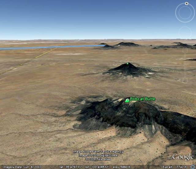
(Picture updated May 23, 2009, text added 11/2/05)
The picture above was generated by Google Earth and is centered on 6,400+ ft. high Bobcat Butte in the Hopi Butte Volcanic Field. (The Hopi Butte Volcanic Field is some 30 to 50 miles NE of Winslow, AZ) A dike in this butte has been dated at 6.62 +/-0.14 MYA with the following description: “basalt dike cutting all units at Bobcat Butte, including lakebeds at top of the butte” (Details in the geochronology tables at GCS2000). It tells us that shortly before the “overflow event” (5.4 MYA) that the flat “Hopi Lake” playa existed at an elevation of slightly under 6,4000 ft.
(end of 11/2/05 addition)
As a side note, Charles Hunt found gravel deposits east of the Kaibab Plateau area that he interpreted as originating in the San Juan Mountains and brought to the area by the ancestral San Juan River. It is likely the temporary resupply episodes by the San Juan were the source of this gravel.
The Day Before – The Kaibab Plateau
Probably the most
perplexing question of the entire Colorado River system
is: How did the Colorado River find a path across the Kaibab Plateau?
If we look at today’s elevations, the South Rim at the Grand
Canyon is over 7,400 feet high and the North Rim is over 8,000
feet. If Hopi Lake and the Wasatch backup system were going to
find a spot to overflow, surely there must have been some
easier location.For example based on current elevations above sea level:
1) Around the north side of the Kaibab Plateau – 5,635 ft.
2) Around the south side of the Kaibab Plateau – 6,490 ft.
3) South over the Mogollon Rim near Show Low – 6,605 ft.
4) Southeast through the San Juan Basin – 6,680 ft.
5) North from Craig, CO to Wamsutter, WY- 6,740 ft.
6) East from Rock Springs, WY – 6,940 ft.
The problem becomes much easier if we can find evidence that the Kaibab was significantly lower 5.4 million years ago. In fact, there seems to be a pretty good argument that it was about 1,400 feet lower at the time of the Grand Canyon event. Additional historical coverage of the Kaibab is covered in the appendix, but this recent uplift is required if this model is to be valid. Thus, we will review the most important evidence here.
If the Kaibab has risen some 1,400 feet in the last 5.4 million years, it is quite possible the uplift is still in progress – and this means earthquakes. There have been five earthquakes of magnitude 5 or higher since 1900 along a line stretching from northeast of Flagstaff to Freedonia. (Beus and Morales) (This is not as active as California’s San Andreas belt, but it is a lot more interesting than Kansas.) By itself, this doesn’t prove much, but it is a hint of some kind of activity.
Additionally, the surface of the Kaibab Plateau resembles a smooth north-south dome. If it had been uplifted to its present height a long time ago, there should be significant gully-type erosion into this dome. Except for the Grand Canyon (and another arroyo canyon at the north end – discussed in the appendix), topographic maps show that there is little surface erosion. It appears that until recently, the Kaibab Plateau was only somewhat elevated (but flatter), and protected from erosion by a thin veneer of Triassic sediments (most likely the Shinarump Conglomerate).
The smoking gun for recent uplift of the Kaibab is provided by Kanab Creek. Kanab Creek flows southward from Fredonia, Arizona and joins the Colorado River in Grand Canyon National Park. The history of river drainage west of the Kaibab Plateau indicates stream flow was south to north until early Miocene time. Hence, Kanab Creek (actually its Hualapai drainage ancestor) didn’t exist until at least early Miocene time. By about 12 million years ago, it had evolved into its present path. Since the river flows southward from Fredonia, this route must have been downhill 12 million years ago.
When Kanab Creek goes through Fredonia, it is crossing a flat plain about 4,700 feet above sea level. As the creek flows southward, it cuts a canyon through “flatish” plateau country. If we smooth out the contour lines of this plateau country as we proceed southward toward the Colorado River, we can get an idea of what it would be like if Kanab Creek weren’t here. Most interestingly, the “flatish” plateau rises to 5,900 feet above sea level. If Kanab Creek were to try to establish its course today, it would have to go uphill 1,200 feet to get to the Colorado. The creek had to be going downhill when it established its course. It is likely this downhill amounted to about 200 feet or so when the creek established its course about 15 million years ago. Thus the 1,200 + 200 = 1,400 foot gain in the height of the “flatish” plateau has to represent local uplift AFTER Kanab Creek established its course.
If this local uplift occurred before the Colorado joined Kanab Creek, then it is likely that both rivers would have followed today’s topography and turned northwest toward the Virgin River as the terrain is all downhill in this direction. Since this did not occur, we know that the local uplift occurred after the Colorado River reached the west side of the Kaibab Plateau some 5.4 million years ago. (We are also assuming that this local uplift extended 25 miles to the east to include the crest of the Kaibab. Topo maps show a westward bowing of contour lines from the crest of the Kaibab to include the Kanab Creek junction area. All of this suggests the whole area was uplifted as a unit.)
A complication arises as this gives an implied elevation of the junction area of 4,500 feet when all this took place 5.4 million years ago. If we check current topographic maps, we find that further west the Colorado River has cut through plateaus that exceed 6,000 feet. The resolution to this problem will be presented later.
At this point let’s
examine what the Kaibab Plateau’s portion of the Grand Canyon
looked like 5.4 million years ago. First, draw a line from the
high point on the north rim to a high point on the south rim.
(North Rim Kaibab Limestone to South Rim Kaibab Limestone.)
Then, use this line to interpolate today’s elevation of the
Kaibab Limestone above the deepest part of the gorge. The
resulting calculation extrapolates to 7,700 feet above sea
level at a point directly over the river. If we subtract 1,400
feet of uplift we get an elevation of 6,300 on the day before
the event. This was the high saddle point of the old
paleocanyon left by the ancestral Little Colorado River when
it flowed through here earlier in the Cenozoic. The floor of
this old canyon was the Kaibab Limestone. The sides consisted
of remnants of the old Moenkopi, which in turn was protected
by a Shinarump Conglomerate cap. The old canyon occupied the
exact path the Colorado River takes today as it crosses the
Kaibab. (Note: A slight variation of this sequence is
possible. This scenario would involve a little less recent
uplift combined with the old canyon eroded a little deeper
into the Kaibab Limestone.)On the east side of this old canyon, the Hopi Lake/Bidahochi sediment system had been creeping higher for millions of years. Each time the Wasatch would ratchet a little higher, the lake/sediment system would also have to rise to reestablish equilibrium. On this day before the event, it was within a few inches of the high saddle point of the old canyon.
Return to Part 3 - Oligocene to
the Day Before the Grand Canyon Event
Continue to Part 5 - The Grand Finale
Return to Evolution of the Colorado River Main Page
Web page generated via Sea Monkey's Composer HTML editor
within a Linux Cinnamon Mint 18 operating system.
(Goodbye Microsoft)
Continue to Part 5 - The Grand Finale
Return to Evolution of the Colorado River Main Page
Web page generated via Sea Monkey's Composer HTML editor
within a Linux Cinnamon Mint 18 operating system.
(Goodbye Microsoft)