
Durango Bill's
Paleogeography (Historical Geology) Research
Unaweep Canyon cuts across the Uncompahgre Plateau
(about 20 miles south of Grand Junction, Colorado)
View looking north
where Unaweep Canyon cuts across the Uncompahgre Plateau.
Contour intervals are 100 feet. Today there is no river in
this canyon. The high saddle point within the canyon (just
northwest of the Gill Creek label) forms a divide with local
drainage flowing down each side. However, up to about 7 or 8
million years ago, a large river flowed from east-northeast
(right) to west-southwest (left) through this canyon.
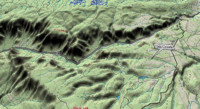
Gill Creek (see
label) is of interest as it uses an ancient tributary to this
ancestral river. For the first 2 miles of its path, Gill Creek
flows eastward following the downhill slope of the terrain.
When it gets to the local road, it does something strange.
Instead of continuing into La Fair Creek/Canyon, Gill Creek
turns uphill (toward the foreground), and then loops to the
west through Casto Reservoir. From there it continues
west-northwest (a combination of up strata/slope, across
strata/slope) to join West Creek which goes down the west side
of Unaweep Canyon. Actually Gill Creek is using a remnant of a
tributary stream system that was here before the Uncompahgre
Plateau started to rise some 10 to 15 million years ago.
(Note: Gill Creek’s path is a natural phenomenon. It is not a
product of a manmade diversion system.)
As mentioned above, the highest point within Unaweep is just northwest of the Gill Creek label. West of the high point, the gradient is only gradually downhill for the first 15 miles indicating the ancestral river abandoned this route before canyon cutting from the Grand Canyon event had backed up this far. (Otherwise it would have rapidly cut down through the west side of the Uncompahgre Plateau.) This means the canyon had to be abandoned at least 4-5 million years ago. On the other hand, the canyon walls appear to have undergone little erosion which means it can't be very old. A ballpark estimate would indicate that a river was here less than 10 million years ago. Thus we get an estimated age of 7 (+/- 3) million years ago when the canyon was abandoned
Prior to 30 million years ago, the ancestral Colorado River flowed north from Colorado into Wyoming. About 25 to 30 million years ago the Rabbit Ears Range rose in northern Colorado blocking the former path of the ancestral Colorado River. The river turned westward and established a new route across this area. The Gunnison River joined the ancestral Colorado on the east side of Unaweep Canyon just to the northwest of Cactus Park (off the right edge of the picture).
For the next 15 or 20 million years the rivers maintained these routes. During the mid Miocene (about 10 to 15 million years ago), the Uncompahgre Plateau underwent an uplift. For a while, the river tried to maintain this course and dug Unaweep Canyon. However, it eventually found an easier route around the north end where it is found today.
Gravel deposits indicate the Gunnison River continued to flow through the canyon for a short while, but before long, it too abandoned the route and turned more northwesterly to join the Colorado. The Uncompahgre Plateau continued to rise a few hundred feet more after these events to reach its present height. The old abandoned canyon remains as a reminder that at one time things were a little different than they are today.
A (tentative and somewhat speculative) summary of Unaweep Canyon’s history might look like:
About 25 to 30 million years ago the ancestral Colorado turned westward and established a westward course over the Uncompahgre Plateau. The plateau was thousands of feet lower than it is today. The present East and West Creeks mark this ancestral course. The Gunnison River flowed westward from the current Black Canyon area, and then northwestward across Cactus Park to join the Colorado River at the northwest end of Cactus Park.
About 10 to 15 million years ago the Uncompahgre Plateau began to rise. The rivers begin to cut down to form Unaweep Canyon and Cactus Park.
About 7 to 10 million years ago the Colorado River found an easier route around the north end of the Uncompahgre Plateau. The Gunnison River continued to follow through Cactus Park and Unaweep Canyon.
About 7 to 9 million years ago the Uncompahgre Plateau was still rising and the Gunnison River abandoned Unaweep Canyon. Canyons on the northeast side of the Uncompahgre Plateau were entrenched. Hence, from the northwest end of Cactus Park, the Gunnison flowed northeastward through the Colorado's former canyon (the current lower half of East Creek). The Gunnison eroded this route deeper before the backup system reached this far.
About 5.4 to 7 million years ago. The backup system from Utah's rising Wasatch reached the Unaweep/Cactus Park area. Unaweep had risen high enough so that it stayed high and dry. However, the Gunnison River filled Cactus Park (and the lower East Creek Canyon) with thick gravel deposits.
About 4 to 6 million years ago, the Gunnison abandoned Cactus Park. Sediment brought in from the east by the Colorado and Gunnison Rivers forced the Gunnison to remain on the west side of the Grand Valley. The Gunnison meandered northwestward across the Grand Valley establishing its present course.
About 4 to 5 million years ago. The Colorado River had started to cut the Grand Canyon. As the exit elevation for the Colorado Plateau was lowered, canyon cutting and generalized erosion worked back upstream. The two rivers became entrenched in their current paths (including meanders in the Gunnison to the east of Cactus Park).
About 4 million years ago to present. Grand Valley eroded down to its present elevation. East Creek removed the sediments and gravel deposits that were left in the Colorado's path to the north and northeast of Cactus Park, and then continued to erode downward to form its own canyon. In Cactus Park, most but not all of the stream deposits left by the Gunnison were also washed away by Gibbler Creek. In the high areas of Unaweep Canyon erosion is very slow due to the very hard Precambrian rock. For example, Gill Creek continues to cut down but only at a very slow rate.
Return to the Image Index Page
Web page generated via Sea Monkey's Composer HTML editor
within a Linux Cinnamon Mint 18 operating system.
(Goodbye Microsoft)