
Durango Bill's
Paleogeography (Historical Geology) Research
San Juan River - Goosenecks and Monument Upwarp, Utah
Contour intervals
are 100 feet. This view to the north shows the San Juan River
near Mexican Hat, Utah with U. S. Route 163 crossing the river
at Mexican Hat. The highest mesa at the top center of the
picture is the Cedar Mesa portion of the Monument Upwarp.
Structurally the upwarp continues across the river to include
Douglas Mesa on the south side. Near the exact center of the
picture there as a faintly visible side road (State Route 316)
that goes west and then southwest from the main road and leads
to the famous overlook at The Goosenecks.
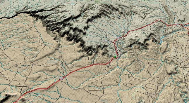
Comb Ridge forms a
north-south hogback near the right edge. At one time the hard
Navajo Sandstone completely covered Cedar Mesa, but erosion
has worn it down to the point where only the upturned edge is
left. The result is a classic western hogback.
Of significance to the geologic history of the area, river gravels are found on the high mesas to the northwest of the highway in the lower left quadrant of the picture. (These are due south of the highest portion of Douglas Mesa.)
Finally, the San Juan River cuts through a small anticline to the southeast of the highway (right of center) to produce the upper portion of San Juan Canyon.
The San Juan River established a route westward through this area about late Oligocene or early Miocene time when it was forced to abandon its earlier route toward the northwest across southwestern Colorado. Its original route through this area was somewhat south of its current path as it tried to find the lowest spot between the Monument Upwarp to the north and the Defiance Plateau to the south. The old gravel deposits on the south side of Douglas Mesa are remnants from this former route. After getting west of the Monument Upwarp, this early version of the San Juan turned north toward the Colorado River.
When the rising Wasatch Ranges began to block the ancestral westward course of the Colorado River into western Utah, a large backup system began to form. Silt brought down by the San Juan covered everything up to at least the 6,300-foot level by 5.4 million years ago. After the Colorado overflowed across the Kaibab Plateau and started cutting the Grand Canyon, canyon cutting began to work its way back upstream. The San Juan at that time happened to be over the southern portion of the Monument Upwarp, and that is where it started cutting downward. The meanders are typical of any river traversing a silt plane, and they were preserved when the river started cutting straight downward. The meanders are particularly concentrated in this area upstream from the Monument Upwarp as the upwarp helped preserve the old silt layers. Finally, the silt backup system also covered the small anticline to the northeast of Mexican Hat and the river happened to be on top of it when it started cutting downward.
Return to the Image Index Page
Web page generated via Sea Monkey's Composer HTML editor
within a Linux Cinnamon Mint 18 operating system.
(Goodbye Microsoft)