
Durango Bill's
Paleogeography (Historical Geology) Research
Evolution of the Colorado River and its Tributaries
by
Bill Butler
Evolution of the Colorado River and its Tributaries
including Formation and Origin of the Grand Canyon
Geologic History of the Grand Canyon
Part 2 – Late Cretaceous through the Eocene
Mid
to Late Cretaceous (About 100 to 75 million years ago)
We can use the
mid-Cretaceous as a starting point as none of the current
major river systems existed. Most of the Colorado Plateau area
was submerged beneath the Cretaceous Sea. High ground extended
from southern Arizona northwest and north into Nevada and
western Utah (Sevier highlands). River systems from this high
ground drained northeastward toward the Cretaceous Sea and
deposited sedimentary layers. These layers would subsequently
form the upper layers of the Mesa Verde Group. In time, the
sea gradually retreated northeastward, with river drainage
eventually extending northeastward across Wyoming. (See Ron
Blakey’s maps at http://jan.ucc.nau.edu/~rcb7/crepaleo.html)
A few short segments of rivers and streams from this period can still be found in current drainage systems. There are several dry arroyos in the southwestern part of the Grand Canyon (especially near Peach Springs Canyon) that date back this far. Also, the current path of the South Platte River from Eleven Mile Reservoir toward the north-northeast is probably a part of the northeastward drainage system that developed as the Cretaceous Sea retreated.
Late Cretaceous (About 75 to 65 million years ago)
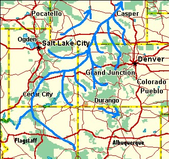
With the Laramide Orogeny, everything started to change. The Rockies began to rise while the San Juan Basin sank in northwest New Mexico. The first of three uplifts of the Defiance Plateau (see the Appendix for evidence) produced high ground in northeastern Arizona while the Monument Plateau emerged in southeast Utah. River drainage on the south side of the San Juan Mountains in Colorado was from the north-northeast to south-southwest into the San Juan Basin. Drainage on the east side of the Defiance Plateau was from west-southwest to east-northeast also into the San Juan Basin. (Please refer to the last map at http://jan.ucc.nau.edu/~rcb7/crepaleo.html)
 As the Defiance and
Monument Plateaus rose, the former southwest to northeast
drainage that extended from Arizona to Wyoming was forced to
find a new path around the west sides of these plateaus. In
between the high mountains in southwest Arizona and the
Defiance Plateau in northeast Arizona, the Little Colorado
River was born with a path that extended from extreme eastern
Arizona west-northwest to near present day Cameron, AZ. This
is essentially where the river is now. (A small lateral
migration from southwest toward the northeast is likely, but
this has not played a significant role in the overall river
pattern.)
As the Defiance and
Monument Plateaus rose, the former southwest to northeast
drainage that extended from Arizona to Wyoming was forced to
find a new path around the west sides of these plateaus. In
between the high mountains in southwest Arizona and the
Defiance Plateau in northeast Arizona, the Little Colorado
River was born with a path that extended from extreme eastern
Arizona west-northwest to near present day Cameron, AZ. This
is essentially where the river is now. (A small lateral
migration from southwest toward the northeast is likely, but
this has not played a significant role in the overall river
pattern.)
The first uplift of the Kaibab Plateau also occurred at this time. (Two subsequent uplifts (documented later in the paper) will be needed to account for the remainder of its present height - relative to areas immediately east and west of the plateau. This initial uplift accounted for about one third of its present relative height.) The uplift complicates where the Little Colorado flowed after it got to present day Cameron, AZ. It is much easier to explain the evolution of the Grand Canyon if we assume the Little Colorado had a head start on the Kaibab’s uplift and continued west-northwest across it between the canyon’s present North and South Rims. (There is no way to verify this, but other scenarios make things much more difficult). (See later sections and the appendix for a chronology of the Kaibab Plateau). Of course, it would dig a canyon in the process. This early canyon was in Mesozoic Era deposits directly above the Kaibab Plateau portion of today’s Grand Canyon. The Mesozoic deposits have long since eroded away, but this ancient canyon would determine why the Colorado River would pick this particular spot for the Grand Canyon event 5.4 million years ago.
After reaching the west side of the Kaibab Plateau, the ancestral Little Colorado turned north near the present course of Kanab Creek. The northward course allowed it to carry sediments to what is now Brice Canyon National Park. From here, the river continued northeastward following drainage established earlier in the Cretaceous, and exited the region through Wyoming.
Meanwhile in central and southern Arizona, drainage continued from the south-southwest to north-northeast with the largest tributary to the Little Colorado running from the Peach Springs area north to near the present Whitmore Wash. From there, it turned northeast to meet the ancestral Little Colorado near or a little north of the present junction of Kanab Creek and the Colorado River.
This paragraph added on 1/28/2014: A paper published in “nature geoscience” http://www.nature.com/ngeo/journal/vaop/ncurrent/full/ngeo2065.html indicates that drainage over the Hurricane Fault zone was toward the northwest at this time. This would mean that the above tributary continued NNW from Whitmore Wash around the west side of the present Mt. Trumbell area and then turn to the NE to join the ancestral Little Colorado near the present Utah border. The model given here has no problem with this modification.
Drainage in western Colorado also began at this time. The Gunnison was the primary river with a course close to where it is now except it was a few miles further north of the present Black Canyon. (Later, it was pushed southward over the Black Canyon by volcanic eruptions in the West Elk Mountains. See Roadside Geology of Colorado – page 282.) However, from Grand Junction, Colorado, it continued north into Wyoming.
In northern Colorado the headwaters of the future Colorado River formed east of the Gore Range, and flowed north into Wyoming. Part of the upper end of this drainage still exists as Tenmile Creek (Highway I-70 uses Tenmile Canyon to cut through the Gore Range) and the Blue River. (Note: The current Gore Range won’t be uplifted until Miocene time which is when Ten Mile Creek cut the canyon. A much lower version of the range existed during Laramide time. The appendix has a more detailed look at the history of the Gore Range.) What will become the present Colorado River in the Glenwood Canyon area was merely a minor tributary feeding the Gunnison.
Finally, drainage out of the San Juan Basin is unknown. The climate was wet implying some river had to go somewhere. There are hints it drained east or east-southeast slightly to the north of New Mexico’s Jemez Caldera, but detailed evidence is lacking. (The Rio Gallina currently cuts a 2,000-foot deep canyon from WNW to ESE through high ridges and mesas just north of the caldera. Based on present topography it would have been much easier for the Gallina to follow a course to the SSW around the west side of the Jemez Caldera. It seems logical that the river is opportunistically using an ancestral path established by some ancient drainage. Also, the town of Gallina sits in another WNW to ESE valley through these high ridges. There is no stream through this valley now, but at some time in the past, something cut this valley. Still other west to east breaches cross ridges further north.)
Paleocene (About 65 to 54 million years ago)
The main part of the Rockies continued to rise and the San Juan Basin continued to sink. As a further complication, most of eastern Utah was pushed northward some sixty miles. (Beus & Morales pages 275, 276) This in turn crumpled the terrain in northeast Utah with the Uinta Mountains pushing up and the Uinta Basin down. While the current lowest part of the Uinta Basin is just south of the Uinta Mountains, the deepest section during the Paleocene is where the Tavaputs Plateau is located today. (This is assumed, as this is where the thickest early Tertiary deposits exist.)
The sinking basins in
Utah resulted in the formation of a large shallow lake system
over what is now the Wasatch Mountains with the lake(s)
subsequently expanding across much of central Utah,
northwestern Colorado, and southwestern Wyoming during the
Eocene. Except for the expanding lakes, there was little
change in river patterns. Of note: The rivers exiting into
Wyoming transported large volumes of silt. (e.g. By the end of
the Oligocene), most of the Laramie Range was buried. Some of
the rivers and streams that crossed the range from southwest
to northeast would be appropriated by subsequent local
drainage when erosion would once again expose the range. This
mixture of old and recent topography is thus the origin of the
180-degree turns in Laramie Range rivers (e.g. the North
Laramie River) that reverse direction to cut back through the
crest of the range.)
(These paragraphs inserted on Aug. 23, 2002. The Aug. 2002 issue of GSA Today included an article that would indicate the northeast side of the Colorado Plateau and its extension into Wyoming were near present elevations during the early Tertiary. The model presented here implies that this area was only slightly above sea level for the following reasons:
A very large amount of material was eroded from the southwest side of the Colorado Plateau in the early Tertiary. At the same time a very large amount of material was deposited in the area from Utah’s Tavaputs Plateau extending northeastward across Wyoming; and in the process, virtually burying the Laramie, Owl Creek, and Bighorn Mountains (Late Cretaceous uplifts). (Added 2/17/07: There is some evidence that these other northern ranges have also undergone multiple periods of uplift. Thus lesser amounts of sediment would be required in these areas.) Unless there is some other “From – To” coupling, this implies a large river system flowed from central Arizona north northeastward across Wyoming. In order to bury these mountain ranges, their crests could not have been more than a few thousand feet above sea level. Also, if the intermountain flatlands across the rest of Wyoming were near sea level, then they would be a logical receptive area for these sediments. After these mountain ranges had been virtually buried, the ancestors of today’s river systems established courses across the mountain ranges. Thus, today, the North Platte River cuts across the Seminoe Mountains, the Laramie and North Laramie Rivers cross the Laramie Range, the Wind River cuts through the Owl Creek Mountains (Wind River Canyon), and the Bighorn River cuts across the Bighorn Mountains. This entire time sequence is illustrated on pages 19-21 of the 1998 edition of “Roadside Geology of Wyoming”.
The second piece of
evidence that the northeast part of the Colorado Plateau and
Wyoming were at low elevations during the early Tertiary is
provided by the “Rim Gravels” that were washed from southwest
to northeast onto the southwest edge of the Colorado Plateau.
These “Rim Gravels” are typically found at elevations of 3,500
to 5,000 feet on the west (down dropped) side of the
Hurricane/Toroweap Faults, and at elevations of 5,500 to 6,000
feet on the east (presumably more stable) side of the faults.
If we assume that these eastern deposits have been at a more
or less constant elevation since the early Tertiary, then the
early Tertiary surface had to be eroded down to the 5,500 to
6,000-foot level before the “Rim Gravels” were deposited. (Of
note, the eroded material does not exist in any nearby “closed
basin”.) Since rivers at this time flowed northward into
Wyoming, all downstream elevations had to be lower than 5,500
to 6,000 feet - including Wyoming. The current lowest
elevations along the Continental Divide in Wyoming are about
7,000 feet. Thus Wyoming had to be at a lower elevation
during the early Tertiary, and was not lifted to its present
elevation until after the Oligocene.
End of Aug. 23, 2002 update)
It is significant to note that the Little Colorado continued to flow northwest from Cameron, AZ across the Kaibab Plateau (While somewhat elevated, it was still much lower then than it is now) to the Brice Canyon area. Sediment eroded from eastern Arizona was deposited around present day Brice Canyon and further north. (See the Kaibab Plateau sequence in the appendix.) A technical paper (“Paleocene to Early Oligocene Paleography, SW Utah”) presented at the Grand Canyon Symposium 2000 provided evidence of this south to north flow in the vicinity of Brice Canyon.
The ancestral Colorado River probably continued to flow to the north into Wyoming staying east of the present Gore Range. Meanwhile the Gunnison continued its path to near Grand Junction before entering the growing lake system. The lake itself continued to drain northeastward out through Wyoming.
Eocene (About 54 to 38 million years ago)
Most of the Laramide buckling ended during the Eocene except the Uinta Mountains continued to rise while the Uinta Basin continued to sink. The Little Colorado maintained the path that it followed in the Paleocene and filled the southwestern end of ancestral Lake Flagstaff with silt. Meanwhile the northern end of the lake expanded due to continued sinking of the Uinta Basin. With these changes Lake Flagstaff was renamed Lake Uinta. Lake Uinta (and/or a series of lakes) grew to cover large areas of northwest Colorado and southwest Wyoming. (In Wyoming it is referred to as Lake Gosiute.)
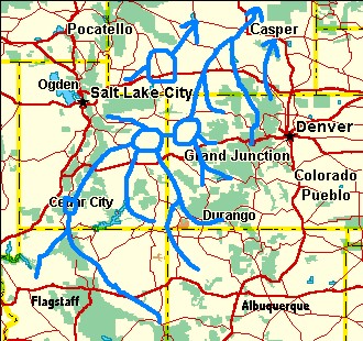 At least 4,000 feet of
sediments were deposited in the present day Tavaputs
Plateau area of this basin. During the Eocene the
ancestors of the Green, Yampa, Colorado, and Gunnison rivers
were well to the east of the Tavaputs, and the ancestral
Little Colorado was further west over the Wasatch. Some of the
Tavaputs sediments may have eroded off the Uintas. However,
the Uintas are 100 miles away from this section and the
sediments would have to be transported southward across an
area where primary drainage was toward the northeast.
Secondly, the shear volume of the Tavaputs sediments far
exceeds the volume the Uintas could have provided. Thus, we
must look to other sediment sources for these thick layers -
especially the 4,000 feet of sandstone in the Tavaputs
Plateau. (See the following paragraphs).
At least 4,000 feet of
sediments were deposited in the present day Tavaputs
Plateau area of this basin. During the Eocene the
ancestors of the Green, Yampa, Colorado, and Gunnison rivers
were well to the east of the Tavaputs, and the ancestral
Little Colorado was further west over the Wasatch. Some of the
Tavaputs sediments may have eroded off the Uintas. However,
the Uintas are 100 miles away from this section and the
sediments would have to be transported southward across an
area where primary drainage was toward the northeast.
Secondly, the shear volume of the Tavaputs sediments far
exceeds the volume the Uintas could have provided. Thus, we
must look to other sediment sources for these thick layers -
especially the 4,000 feet of sandstone in the Tavaputs
Plateau. (See the following paragraphs).
In northwestern New Mexico, whatever force that had been pulling the San Juan Basin down stopped. The result was an isostatic rebound with a profound effect on river drainage systems. Herfano Mountain, which is located in the middle of the San Juan Basin some 20 miles south-southeast of Bloomfield, New Mexico, provides evidence of this rebound. The mountain itself is a shrinking remnant of sedimentary layers that once covered large areas of the San Juan Basin. The mountain is composed of early Tertiary sediments that flowed into the basin, but the subsequent rebound has lifted the top of the mountain to over 7,400 feet. This is nearly 1,000 feet higher than the current elevation of the Animas River in Durango, CO.
As the center of the basin rebounded, (areas to the east also rose blocking the possible earlier eastward drainage), a new drainage system formed which radiated outward from the center of the basin toward its periphery. Rivers and streams that previously flowed into the basin now had to find another route around its circumference.
On the western side of the San Juan Basin, drainage from the Defiance Plateau flowed east-northeast toward the basin until it reached the basin’s periphery. Here it had to find a new path since it met head on with the new drainage coming out of the basin. The new choice would have to form a right angle with the old path. The closest low elevation was Lake Uinta – hence the ancestral Chaco River formed flowing north toward the lake. This path is very close to where the Chuska Sandstone exists today high in the Chuska Mountains. Recent evidence implies the Chuska Sandstone dates all the way back to the Cretaceous instead of the Tertiary (as given in the 1995 version of the “Roadside Geology of New Mexico” and other sources), but if a Tertiary source for this deposit were needed, the ancestral Chaco River was capable of supplying the necessary sediments.
The ancient Chaco River probably continued north from New Mexico into Colorado. There isn’t any direct evidence of its exact path, but there are several canyons that cut uphill into the rising strata of the Dolores Anticline. (Please refer to the Dolores web page for pictures of this section of southwest Colorado.) A reasonable “Guesstimate” is the Bishop/Summit Canyon complex northwest of Egnar, Colorado had its origin as a remnant of the ancestral Chaco. If we smooth out the contours across the top of the anticline, Summit Creek would have to climb over 700 vertical feet before it could go downhill to the present Dolores River. It is probable that this path was established by a river before the anticline rose, and the current local drainage continued to use this remnant after the Chaco was truncated back into New Mexico.
A similar peripheral phenomenon was taking place on the north edge of the San Juan Basin. Drainage flowing south-southwest from the San Juan Mountains had to find a new right angle path when it reached the circumference zone. The result was another new river flowing toward the west-northwest until it cleared the San Juan Mountains. The best estimate of its path was from the eastern portion of present day Navajo Lake to slightly south of Durango. From here, it continued west-northwest to the present McPhee Reservoir followed by a straight shot north through extreme western Colorado toward Lake Uinta. (At this time, the Monument Uplift in southeastern Utah prevented a continuation toward the west. Also, we are assuming the influence of local K-T intrusions and uplift in Colorado’s La Plata Mountains was limited to areas north of the current town of Hesperus.)
The northward flowing Chaco River joined this new river near the present town of Slick Rock, CO. with the combination flowing north to the present location of Gateway, CO. Finally, this new river bent toward the northwest and emptied into Lake Uinta. Thus, the ancestral San Juan River was born. (At present, the Dolores River occupies this ancestral course from McPhee Reservoir north. A more detailed derivation of this path is given in the appendix.). The combination of the sinking Uinta Basin and the availability of the San Juan River to feed it quickly deposited 4,000 feet of sediments (mostly sandstone of the Wasatch Formation) in the Tavaputs Plateau area.
Steven M. Cather has submitted a manuscript to the “The Geology of New Mexico” that has a sharply different drainage system for the San Juan Basin as of ~49 million years ago. Click here for details on why this other drainage model is not supported by the evidence.
Return to Part 1 - Introduction
Continue to Part 3 - Oligocene until the Day Before the Event
Return to Evolution of the Colorado River Main Page
Web page generated via Sea Monkey's Composer HTML editor
within a Linux Cinnamon Mint 18 operating system.
(Goodbye Microsoft)
A few short segments of rivers and streams from this period can still be found in current drainage systems. There are several dry arroyos in the southwestern part of the Grand Canyon (especially near Peach Springs Canyon) that date back this far. Also, the current path of the South Platte River from Eleven Mile Reservoir toward the north-northeast is probably a part of the northeastward drainage system that developed as the Cretaceous Sea retreated.
Late Cretaceous (About 75 to 65 million years ago)
With the Laramide Orogeny, everything started to change. The Rockies began to rise while the San Juan Basin sank in northwest New Mexico. The first of three uplifts of the Defiance Plateau (see the Appendix for evidence) produced high ground in northeastern Arizona while the Monument Plateau emerged in southeast Utah. River drainage on the south side of the San Juan Mountains in Colorado was from the north-northeast to south-southwest into the San Juan Basin. Drainage on the east side of the Defiance Plateau was from west-southwest to east-northeast also into the San Juan Basin. (Please refer to the last map at http://jan.ucc.nau.edu/~rcb7/crepaleo.html)
As the Defiance and
Monument Plateaus rose, the former southwest to northeast
drainage that extended from Arizona to Wyoming was forced to
find a new path around the west sides of these plateaus. In
between the high mountains in southwest Arizona and the
Defiance Plateau in northeast Arizona, the Little Colorado
River was born with a path that extended from extreme eastern
Arizona west-northwest to near present day Cameron, AZ. This
is essentially where the river is now. (A small lateral
migration from southwest toward the northeast is likely, but
this has not played a significant role in the overall river
pattern.)The first uplift of the Kaibab Plateau also occurred at this time. (Two subsequent uplifts (documented later in the paper) will be needed to account for the remainder of its present height - relative to areas immediately east and west of the plateau. This initial uplift accounted for about one third of its present relative height.) The uplift complicates where the Little Colorado flowed after it got to present day Cameron, AZ. It is much easier to explain the evolution of the Grand Canyon if we assume the Little Colorado had a head start on the Kaibab’s uplift and continued west-northwest across it between the canyon’s present North and South Rims. (There is no way to verify this, but other scenarios make things much more difficult). (See later sections and the appendix for a chronology of the Kaibab Plateau). Of course, it would dig a canyon in the process. This early canyon was in Mesozoic Era deposits directly above the Kaibab Plateau portion of today’s Grand Canyon. The Mesozoic deposits have long since eroded away, but this ancient canyon would determine why the Colorado River would pick this particular spot for the Grand Canyon event 5.4 million years ago.
After reaching the west side of the Kaibab Plateau, the ancestral Little Colorado turned north near the present course of Kanab Creek. The northward course allowed it to carry sediments to what is now Brice Canyon National Park. From here, the river continued northeastward following drainage established earlier in the Cretaceous, and exited the region through Wyoming.
Meanwhile in central and southern Arizona, drainage continued from the south-southwest to north-northeast with the largest tributary to the Little Colorado running from the Peach Springs area north to near the present Whitmore Wash. From there, it turned northeast to meet the ancestral Little Colorado near or a little north of the present junction of Kanab Creek and the Colorado River.
This paragraph added on 1/28/2014: A paper published in “nature geoscience” http://www.nature.com/ngeo/journal/vaop/ncurrent/full/ngeo2065.html indicates that drainage over the Hurricane Fault zone was toward the northwest at this time. This would mean that the above tributary continued NNW from Whitmore Wash around the west side of the present Mt. Trumbell area and then turn to the NE to join the ancestral Little Colorado near the present Utah border. The model given here has no problem with this modification.
Drainage in western Colorado also began at this time. The Gunnison was the primary river with a course close to where it is now except it was a few miles further north of the present Black Canyon. (Later, it was pushed southward over the Black Canyon by volcanic eruptions in the West Elk Mountains. See Roadside Geology of Colorado – page 282.) However, from Grand Junction, Colorado, it continued north into Wyoming.
In northern Colorado the headwaters of the future Colorado River formed east of the Gore Range, and flowed north into Wyoming. Part of the upper end of this drainage still exists as Tenmile Creek (Highway I-70 uses Tenmile Canyon to cut through the Gore Range) and the Blue River. (Note: The current Gore Range won’t be uplifted until Miocene time which is when Ten Mile Creek cut the canyon. A much lower version of the range existed during Laramide time. The appendix has a more detailed look at the history of the Gore Range.) What will become the present Colorado River in the Glenwood Canyon area was merely a minor tributary feeding the Gunnison.
Finally, drainage out of the San Juan Basin is unknown. The climate was wet implying some river had to go somewhere. There are hints it drained east or east-southeast slightly to the north of New Mexico’s Jemez Caldera, but detailed evidence is lacking. (The Rio Gallina currently cuts a 2,000-foot deep canyon from WNW to ESE through high ridges and mesas just north of the caldera. Based on present topography it would have been much easier for the Gallina to follow a course to the SSW around the west side of the Jemez Caldera. It seems logical that the river is opportunistically using an ancestral path established by some ancient drainage. Also, the town of Gallina sits in another WNW to ESE valley through these high ridges. There is no stream through this valley now, but at some time in the past, something cut this valley. Still other west to east breaches cross ridges further north.)
Paleocene (About 65 to 54 million years ago)
The main part of the Rockies continued to rise and the San Juan Basin continued to sink. As a further complication, most of eastern Utah was pushed northward some sixty miles. (Beus & Morales pages 275, 276) This in turn crumpled the terrain in northeast Utah with the Uinta Mountains pushing up and the Uinta Basin down. While the current lowest part of the Uinta Basin is just south of the Uinta Mountains, the deepest section during the Paleocene is where the Tavaputs Plateau is located today. (This is assumed, as this is where the thickest early Tertiary deposits exist.)
The sinking basins in
Utah resulted in the formation of a large shallow lake system
over what is now the Wasatch Mountains with the lake(s)
subsequently expanding across much of central Utah,
northwestern Colorado, and southwestern Wyoming during the
Eocene. Except for the expanding lakes, there was little
change in river patterns. Of note: The rivers exiting into
Wyoming transported large volumes of silt. (e.g. By the end of
the Oligocene), most of the Laramie Range was buried. Some of
the rivers and streams that crossed the range from southwest
to northeast would be appropriated by subsequent local
drainage when erosion would once again expose the range. This
mixture of old and recent topography is thus the origin of the
180-degree turns in Laramie Range rivers (e.g. the North
Laramie River) that reverse direction to cut back through the
crest of the range.)(These paragraphs inserted on Aug. 23, 2002. The Aug. 2002 issue of GSA Today included an article that would indicate the northeast side of the Colorado Plateau and its extension into Wyoming were near present elevations during the early Tertiary. The model presented here implies that this area was only slightly above sea level for the following reasons:
A very large amount of material was eroded from the southwest side of the Colorado Plateau in the early Tertiary. At the same time a very large amount of material was deposited in the area from Utah’s Tavaputs Plateau extending northeastward across Wyoming; and in the process, virtually burying the Laramie, Owl Creek, and Bighorn Mountains (Late Cretaceous uplifts). (Added 2/17/07: There is some evidence that these other northern ranges have also undergone multiple periods of uplift. Thus lesser amounts of sediment would be required in these areas.) Unless there is some other “From – To” coupling, this implies a large river system flowed from central Arizona north northeastward across Wyoming. In order to bury these mountain ranges, their crests could not have been more than a few thousand feet above sea level. Also, if the intermountain flatlands across the rest of Wyoming were near sea level, then they would be a logical receptive area for these sediments. After these mountain ranges had been virtually buried, the ancestors of today’s river systems established courses across the mountain ranges. Thus, today, the North Platte River cuts across the Seminoe Mountains, the Laramie and North Laramie Rivers cross the Laramie Range, the Wind River cuts through the Owl Creek Mountains (Wind River Canyon), and the Bighorn River cuts across the Bighorn Mountains. This entire time sequence is illustrated on pages 19-21 of the 1998 edition of “Roadside Geology of Wyoming”.
The second piece of
evidence that the northeast part of the Colorado Plateau and
Wyoming were at low elevations during the early Tertiary is
provided by the “Rim Gravels” that were washed from southwest
to northeast onto the southwest edge of the Colorado Plateau.
These “Rim Gravels” are typically found at elevations of 3,500
to 5,000 feet on the west (down dropped) side of the
Hurricane/Toroweap Faults, and at elevations of 5,500 to 6,000
feet on the east (presumably more stable) side of the faults.
If we assume that these eastern deposits have been at a more
or less constant elevation since the early Tertiary, then the
early Tertiary surface had to be eroded down to the 5,500 to
6,000-foot level before the “Rim Gravels” were deposited. (Of
note, the eroded material does not exist in any nearby “closed
basin”.) Since rivers at this time flowed northward into
Wyoming, all downstream elevations had to be lower than 5,500
to 6,000 feet - including Wyoming. The current lowest
elevations along the Continental Divide in Wyoming are about
7,000 feet. Thus Wyoming had to be at a lower elevation
during the early Tertiary, and was not lifted to its present
elevation until after the Oligocene.End of Aug. 23, 2002 update)
It is significant to note that the Little Colorado continued to flow northwest from Cameron, AZ across the Kaibab Plateau (While somewhat elevated, it was still much lower then than it is now) to the Brice Canyon area. Sediment eroded from eastern Arizona was deposited around present day Brice Canyon and further north. (See the Kaibab Plateau sequence in the appendix.) A technical paper (“Paleocene to Early Oligocene Paleography, SW Utah”) presented at the Grand Canyon Symposium 2000 provided evidence of this south to north flow in the vicinity of Brice Canyon.
The ancestral Colorado River probably continued to flow to the north into Wyoming staying east of the present Gore Range. Meanwhile the Gunnison continued its path to near Grand Junction before entering the growing lake system. The lake itself continued to drain northeastward out through Wyoming.
Eocene (About 54 to 38 million years ago)
Most of the Laramide buckling ended during the Eocene except the Uinta Mountains continued to rise while the Uinta Basin continued to sink. The Little Colorado maintained the path that it followed in the Paleocene and filled the southwestern end of ancestral Lake Flagstaff with silt. Meanwhile the northern end of the lake expanded due to continued sinking of the Uinta Basin. With these changes Lake Flagstaff was renamed Lake Uinta. Lake Uinta (and/or a series of lakes) grew to cover large areas of northwest Colorado and southwest Wyoming. (In Wyoming it is referred to as Lake Gosiute.)
At least 4,000 feet of
sediments were deposited in the present day Tavaputs
Plateau area of this basin. During the Eocene the
ancestors of the Green, Yampa, Colorado, and Gunnison rivers
were well to the east of the Tavaputs, and the ancestral
Little Colorado was further west over the Wasatch. Some of the
Tavaputs sediments may have eroded off the Uintas. However,
the Uintas are 100 miles away from this section and the
sediments would have to be transported southward across an
area where primary drainage was toward the northeast.
Secondly, the shear volume of the Tavaputs sediments far
exceeds the volume the Uintas could have provided. Thus, we
must look to other sediment sources for these thick layers -
especially the 4,000 feet of sandstone in the Tavaputs
Plateau. (See the following paragraphs).In northwestern New Mexico, whatever force that had been pulling the San Juan Basin down stopped. The result was an isostatic rebound with a profound effect on river drainage systems. Herfano Mountain, which is located in the middle of the San Juan Basin some 20 miles south-southeast of Bloomfield, New Mexico, provides evidence of this rebound. The mountain itself is a shrinking remnant of sedimentary layers that once covered large areas of the San Juan Basin. The mountain is composed of early Tertiary sediments that flowed into the basin, but the subsequent rebound has lifted the top of the mountain to over 7,400 feet. This is nearly 1,000 feet higher than the current elevation of the Animas River in Durango, CO.
As the center of the basin rebounded, (areas to the east also rose blocking the possible earlier eastward drainage), a new drainage system formed which radiated outward from the center of the basin toward its periphery. Rivers and streams that previously flowed into the basin now had to find another route around its circumference.
On the western side of the San Juan Basin, drainage from the Defiance Plateau flowed east-northeast toward the basin until it reached the basin’s periphery. Here it had to find a new path since it met head on with the new drainage coming out of the basin. The new choice would have to form a right angle with the old path. The closest low elevation was Lake Uinta – hence the ancestral Chaco River formed flowing north toward the lake. This path is very close to where the Chuska Sandstone exists today high in the Chuska Mountains. Recent evidence implies the Chuska Sandstone dates all the way back to the Cretaceous instead of the Tertiary (as given in the 1995 version of the “Roadside Geology of New Mexico” and other sources), but if a Tertiary source for this deposit were needed, the ancestral Chaco River was capable of supplying the necessary sediments.
The ancient Chaco River probably continued north from New Mexico into Colorado. There isn’t any direct evidence of its exact path, but there are several canyons that cut uphill into the rising strata of the Dolores Anticline. (Please refer to the Dolores web page for pictures of this section of southwest Colorado.) A reasonable “Guesstimate” is the Bishop/Summit Canyon complex northwest of Egnar, Colorado had its origin as a remnant of the ancestral Chaco. If we smooth out the contours across the top of the anticline, Summit Creek would have to climb over 700 vertical feet before it could go downhill to the present Dolores River. It is probable that this path was established by a river before the anticline rose, and the current local drainage continued to use this remnant after the Chaco was truncated back into New Mexico.
A similar peripheral phenomenon was taking place on the north edge of the San Juan Basin. Drainage flowing south-southwest from the San Juan Mountains had to find a new right angle path when it reached the circumference zone. The result was another new river flowing toward the west-northwest until it cleared the San Juan Mountains. The best estimate of its path was from the eastern portion of present day Navajo Lake to slightly south of Durango. From here, it continued west-northwest to the present McPhee Reservoir followed by a straight shot north through extreme western Colorado toward Lake Uinta. (At this time, the Monument Uplift in southeastern Utah prevented a continuation toward the west. Also, we are assuming the influence of local K-T intrusions and uplift in Colorado’s La Plata Mountains was limited to areas north of the current town of Hesperus.)
The northward flowing Chaco River joined this new river near the present town of Slick Rock, CO. with the combination flowing north to the present location of Gateway, CO. Finally, this new river bent toward the northwest and emptied into Lake Uinta. Thus, the ancestral San Juan River was born. (At present, the Dolores River occupies this ancestral course from McPhee Reservoir north. A more detailed derivation of this path is given in the appendix.). The combination of the sinking Uinta Basin and the availability of the San Juan River to feed it quickly deposited 4,000 feet of sediments (mostly sandstone of the Wasatch Formation) in the Tavaputs Plateau area.
Steven M. Cather has submitted a manuscript to the “The Geology of New Mexico” that has a sharply different drainage system for the San Juan Basin as of ~49 million years ago. Click here for details on why this other drainage model is not supported by the evidence.
Return to Part 1 - Introduction
Continue to Part 3 - Oligocene until the Day Before the Event
Return to Evolution of the Colorado River Main Page
Web page generated via Sea Monkey's Composer HTML editor
within a Linux Cinnamon Mint 18 operating system.
(Goodbye Microsoft)