
Durango Bill's
Paleogeography (Historical Geology) Research
Origin and Formation of Glenwood Canyon, Colorado
The Chronology on how the Colorado River formed Glenwood Canyon
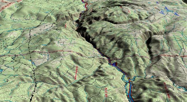
View to the west
from Dotsero to Glenwood Springs, Colorado. Contour intervals
are 100 feet. The major highway is I-70. The Colorado River
cuts through the south side of the White River Plateau to form
Glenwood Canyon. Cottonwood Pass Road (Near electric
transmission lines to the left) crosses Cottonwood Divide some
1,000 feet lower than the average height of the canyon's rims.
Glenwood Canyon is an interesting study in how rivers get into canyons. Cottonwood Divide (lower route to the left around the plateau) is capped with Tertiary lava. Hence it has never been much higher than it is now. The rims of Glenwood Canyon are capped by Mississippi and Pennsylvanian Limestone and would be higher yet if you travel back in time to restore layers that have been eroded away. Even more interesting, upstream from here, the Colorado River could escape to the north near Yampa, Colorado and still stay 1,000 feet lower than the current rims of Glenwood Canyon. Why did the river establish a path across the higher surface?
We go back to our rule that rivers will always take the easiest available path when they first become established. When the Colorado River turned westward by early Miocene time, the White River Plateau had not risen yet. Then after the river had established its course, the plateau rose during the rest of the Miocene. (Recent research indicates much of this uplift has occurred in the last 5 million years.) By the time the plateau started to rise, the river was stuck in a rut. As the plateau rose, the "rut" just got deeper.
It is probable the plateau is still slowly rising with the river cutting ever deeper. The sheer sides of the canyon and steep gradient of the river through it are classic signs of recent activity.
Return to the Image Index Page
Web page generated via Sea Monkey's Composer HTML editor
within a Linux Cinnamon Mint 18 operating system.
(Goodbye Microsoft)