
Durango Bill's
Paleogeography (Historical Geology) Research
Harpers Corner, the Bishop Conglomerate, and Uinta Quartzite
Dinosaur National Monument
The geological evolution of today’s canyon systems in Dinosaur National Monument
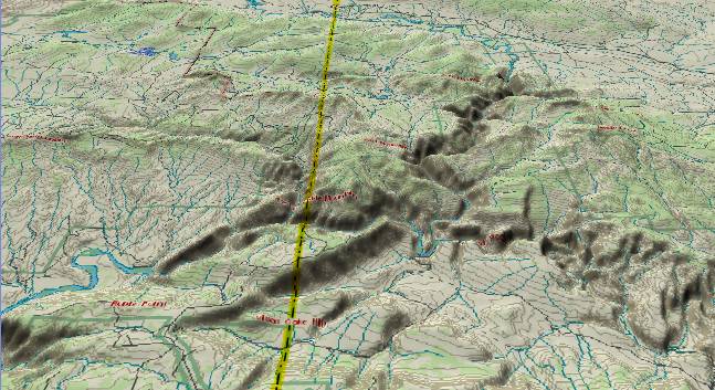
The view above shows
the central portion of Dinosaur National Monument. In the
upper right quadrant, the Green River flows from north to
south through the Canyon of Lodore, and then continues
west-southwestward out of view off the lower left edge. The
Yampa River enters from the lower right edge and flows
west-northwest to join the Green just to the right of the
Harpers Corner Ridge (dark shadow) near the center of the
picture. The yellow line marks the state boundary with Utah to
the west and Colorado to the east.
Harpers Corner Ridge is accessible by a paved road from near Dinosaur, CO. In addition to the spectacular views of the Green and Yampa Canyons, Harpers Corner provides significant clues to river patterns that existed 30 million years ago.
First, the flat top of Harpers Corner, the Diamond Mountain Plateau (near left edge, slightly above center), and the Blue Mountain Plateau (lower left quadrant) are all part of the local Gilbert Peak Erosion Surface that existed 5 to 30 million years ago. In turn this was part of a large valley system that extended from northwest Colorado south to Arizona. River drainage for most of the Tertiary (up to 20 to 25 million years ago) was from Arizona northward into eastern Utah, and then northeastward across Colorado (just to the southeast of Dinosaur National Monument) into Wyoming.
If you filled in Whirlpool Canyon between Harpers Corner and the mountains to the northwest, you would create a 7,500+ ft. above-sea-level barrier that would block current river drainage. Since both the Green and Yampa Rivers have alternate escape routes across Wyoming that stay under 7,000 feet, we know that this portion of Dinosaur Monument has been uplifted at least 1,000 feet since these rivers established their present courses. These rivers started to dig their present canyons only after the Colorado River established its current route across the Kaibab Plateau some 5.4 million years ago. Thus the recent renewed uplift has all taken place in the last 5 million years.
If you visit the Harpers Corner area, you will no doubt notice the rounded red rocks that are liberally scattered across the ground surface. The red rocks are a quartzite that originally was eroded from the high Uinta Mountains some 60-70 miles west of here, and then carried eastward by an ancient river system. The quartzite and accompanying sand was deposited at Harpers Corner (and other locations) and subsequently hardened into the Bishop Conglomerate. In the last few thousand years, much of the cemented sand of the Bishop Conglomerate has eroded away leaving the red quartzite cobbles scattered on the current ground surface. (Outcrops of the original Bishop Conglomerate can be seen on the trail out to the end of Harpers Corner.)
There is also volcanic ash (tuff) that fell into the upper portion of the Bishop Conglomerate. This volcanic ash has been dated at 29 million years old. (See Wallace Hansen’s “Dinosaur’s Restless Rivers”)
When we put this all together, it tells us that 30 million years ago there was a river flowing from west to east that transported the red quartzite from the south side of the high Uinta Mountains eastward to at least Harpers Corner Ridge. (It probably continued east to join the primary river flow that continued into south-central Wyoming.) The river was big enough to transport boulders up to at least a foot in diameter.
Some 20 to 25 million years ago, there was a general uplift across Wyoming. Drainage northward into Wyoming was blocked, and rivers from northern Colorado thus turned westward. This new drainage closely approximated today’s Yampa River.
Some 15 million years ago (+/- 5 million or so) renewed uplift of the Wind River Mountains in Wyoming blocked the former northeastward drainage out of Wyoming’s Green River Basin. A new drainage system developed to the southeast which is today’s Green River.
Also 15 million years ago the Yampa/Green River system continued southward from the lower left corner of the picture through Utah’s present Tavaputs Plateau system (The Green River’s present course through Desolation Canyon). There it met the ancestral Colorado River, and the combined river continued west into western Utah’s salt deserts.
Starting 15 million years ago, the Wasatch Mountains/Plateau system in Utah started to rise. The backup from this event allowed the Browns Park formation to be deposited to the east of Dinosaur Monument.
About 5.4 million years ago the Colorado River found a new route across the Kaibab Plateau and started to dig the Grand Canyon. Canyon-cutting worked its way back upstream, and the Yampa and Green Rivers became entrenched in their current paths.
Finally in the last 5 million years the present highlands in Dinosaur Monument and eastern Uinta mountains have undergone renewed uplift to form today’s canyons.
It is interesting to contemplate all of the above if you happen to take a raft trip down the Yampa or Green Rivers. Imagine that you are camped a short distance to the west of Harpers Corner (e.g. at Jones Hole Campground). If you look to the east you will see the Harpers Corner Ridge towering 2,500 feet above you and glowing red in the sunset. 30 million years ago there was a river flowing from west to east one half mile above your campsite, with this river just grazing the top of Harpers Corner Ridge. Today, this would have to be a “River in the Sky”, but this long vanished river tells us what the landscape looked like 30 million years ago.
Also please see Canyon of Lodore, Colorado and Split Mountain, Utah
Return to the Image Index page
Web page generated via Sea Monkey's Composer HTML editor
within a Linux Cinnamon Mint 18 operating system.
(Goodbye Microsoft)