
Durango Bill's
Paleogeography (Historical Geology) Research
Evolution of the Colorado River and its Tributaries
by
Bill Butler
Evolution of the Colorado River and its Tributaries
including Formation and Origin of the Grand Canyon
Geologic History of the Grand Canyon
Part 5 – The Grand Finale
The Grand Finale
The famous author “Snoopy” might have described the timing of the event as “A Dark and Stormy Night”. It’s possible D. L. Baars could have figured out what day of the week it was. Most likely it was another dry, sunny day similar to billions of other days of geologic time in the southwest. What happened next took at least several months and more likely years to complete. This is still a “day” in geologic time, and thus we’ll describe it as an instantaneous event.
Event Day
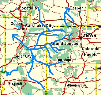 Event Day started
similar to billions of previous days on the Colorado Plateau.
Strain had again been accumulating along Utah’s Wasatch/Sevier
Fault(s); and on Event Day, the offsetting forces along the
fault once again exceeded the frictional resistance of the
opposing rock faces. As it had on thousands of previous
occasions, the Wasatch Plateau lurched upward another few
feet. The westward course of the Colorado River (over the
current Emigrant Pass and down through Salina Canyon)
was once again blocked, but the river knew what to do. As it
had done thousands of times before, the Colorado River and its
tributaries would turn south, deposit another layer of silt
across southern Utah and raise the level of the Hopi/Bidahochi
system in Arizona. After this backup system had been raised to
whatever level was needed, the river could go back to its
westward course through the rising Wasatch Plateau and out
into the Utah deserts. However, this time things were
different. Hopi Lake didn’t rise – it overflowed!
Event Day started
similar to billions of previous days on the Colorado Plateau.
Strain had again been accumulating along Utah’s Wasatch/Sevier
Fault(s); and on Event Day, the offsetting forces along the
fault once again exceeded the frictional resistance of the
opposing rock faces. As it had on thousands of previous
occasions, the Wasatch Plateau lurched upward another few
feet. The westward course of the Colorado River (over the
current Emigrant Pass and down through Salina Canyon)
was once again blocked, but the river knew what to do. As it
had done thousands of times before, the Colorado River and its
tributaries would turn south, deposit another layer of silt
across southern Utah and raise the level of the Hopi/Bidahochi
system in Arizona. After this backup system had been raised to
whatever level was needed, the river could go back to its
westward course through the rising Wasatch Plateau and out
into the Utah deserts. However, this time things were
different. Hopi Lake didn’t rise – it overflowed!
The Hopi/Bidahochi system had been slowly growing for millions of years before the event. Now its surface was about 6,300 feet above sea level (as measured by current Bidahochi deposits in eastern Arizona). As its surface area continued to expand, it was inevitable that it would overflow at the lowest alternative to the inflow/outflow area at its north end. On event day (more likely shortly thereafter) it found this inevitable alternate outlet across the Kaibab Plateau. The Kaibab was about 1,400 feet lower 5.4 million years ago and an old canyon originally carved tens of millions of years earlier cut across it at the 6,300-foot level.
From the top of the Kaibab down the west side of the Kaibab Plateau to Kanab Creek, the overflowing river followed the old canyon carved by the ancestral Little Colorado and abandoned some 30 million years earlier. From there, it would appear the river should have continued west-northwest to the Virgin River. If we check a topographic map of the area, there are no current obstacles higher than 5,050 feet in this direction (as measured by an arc route from Fredonia to the Virgin River). It is likely that this same relative 5,050-foot route was available 5.4 million years ago. (All elevations are expressed in current feet above sea level to facilitate local comparisons. Keep in mind that the whole Colorado Plateau has risen several thousand feet in the last 5.4 million years). However, at Kanab Creek the river turns west-southwest and cuts through plateaus that exceed 6,000 feet. We might suspect that either the Colorado River found an existing canyon to follow from Kanab Creek, or there has been local uplift of the plateaus since the river established its path. It turns out both of these factors have played a part. We will give a chronology outlining how the west-southwest pathway developed followed by “down the river” observations supporting this synopsis (see the “Evolution of the Colorado River from Kanab Creek to the Grand Wash Cliffs” section below). However, first we should review some serious problems with the current published theory regarding the Colorado River west of the Kaibab Plateau.
Chapter 15 in Beus and
Morales derives a model that assumes the Colorado River has
always been in place across the Kaibab Plateau. The model then
gives an argument that it continued west-northwest from Kanab
Creek to some unknown destination until the west-southwest
route opened up some 5.4 million years ago. There are several
major problems with this model. New evidence shows the
Hurricane Fault did not become active until about 3 million
years ago. Thus, the lack of a nick in the Hurricane Cliffs
can no longer be used as evidence that the river wasn’t here.
However, en route to the Hurricane Cliffs, the river would
have to cross a broad flat area that shows little evidence of
recent erosion. If the Colorado River had been here, evidence
of its presence should still be in place. No evidence of the
river has been found.
A second problem concerns coccoliths (microscopic fossils - see Beus & Morales page 317) that originated in the Mancos Shale of the Colorado Plateau. The Colorado River has deposited these microfossils as part of the silt in California’s Salton Trough. The coccoliths did not appear until about 5 million years ago. If the ancestral Colorado River had taken a west-northwest route from Kanab Creek, then at some point it would have intercepted the Virgin River. The Virgin River is firmly entrenched in Virgin Canyon southwest of St. George, Utah; and has followed this route since before the Grand Wash Cliffs existed (at least 15 million years ago). The Virgin River flows southwestward toward the Salton Trough. If the ancestral Colorado River had flowed into the Virgin River before the break point 5.4 million years ago, the coccoliths would have shown up in the Salton Trough courtesy of the Virgin River. Since the coccoliths are not there, the Colorado had to be somewhere else.
If the ancestral Colorado River had flowed westward across this area, it should have left deposits in the Grand Wash trough or at least somewhere in the Muddy Creek Formation, which covers a large area of southeastern Nevada. Joel L. Pederson’s paper at the Grand Canyon Symposium 2000 says it all: “LATE MIOCENE TERMINUS OF THE PALEO-COLORADO RIVER: NOT THE MUDDY CREEK FORMATION NORTH OF LAKE MEAD” (Italics are his.)
Finally, the west-northwest model does not provide a mechanism to change the course of the Colorado from the west-northwest route (with a maximum elevation of 5,050 feet) to the west-southwest route through plateaus that exceed 6,000 feet.
Evolution of the Colorado River from Kanab Creek to the Grand Wash Cliffs
We will first give a brief outline showing the chronology of events and then follow this up with a more detailed “down the river” examination of the evidence. (There is more detail about this sequence in the GCS2000 abstracts.)
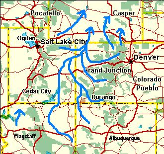 1) Oligocene: River drainage
(e. g. Peach Springs and Havasu Creeks) was from south to
north from Arizona toward Utah – most likely continuing
northward near the present Sevier River. This flow continued
for a brief period after the Little Colorado relocated to the
east side of the rising Kaibab Plateau (2nd uplift). Drainage
systems gradually became very flat with no canyons
(Paleocanyons near Peach Springs Canyon slowly filled in with
“Rim Gravels”).
1) Oligocene: River drainage
(e. g. Peach Springs and Havasu Creeks) was from south to
north from Arizona toward Utah – most likely continuing
northward near the present Sevier River. This flow continued
for a brief period after the Little Colorado relocated to the
east side of the rising Kaibab Plateau (2nd uplift). Drainage
systems gradually became very flat with no canyons
(Paleocanyons near Peach Springs Canyon slowly filled in with
“Rim Gravels”).
2) Early Miocene: The rising Wasatch Plateau in Utah blocked the northward exit route. Drainage slowly reorganized to flow southwestward. (For a while, there was a period during the early Miocene when drainage was confined within basins with no external exit).
3) Mid Miocene: Diamond Creek developed westward as part of the new Hualapai Drainage System and then north-northwest to the newly formed Grand Wash Cliffs (and trough). This part of the new Hualapai Drainage was in place about 15 million years ago. By 12 million years ago, the Hualapai Drainage (usually dry except during rainy periods) was complete from Kanab Creek to the Grand Wash Cliffs. A shallow continuous canyon forms.
4) Mid to Late Miocene: The
Hurricane and Toroweap Faults are not active yet. Accordingly,
the Kanab and Uinkarat Plateaus have not risen yet. The
Hualapai is free to establish its course. Hualapai Canyons
grow wider and deeper to encompass most of the current
Esplanade surface.
5) 5.4 million years ago: The Colorado River overflows the Kaibab Plateau and appropriates the Hualapai Drainage System (extends from Kanab Creek to the Grand Wash Cliffs). Serious canyon cutting begins.
6) 5.4 million years ago to the present: The Toroweap and Hurricane Faults become active about 3 million years ago. Uplifts of the Kaibab (3rd uplift), Kanab, and Uinkarat Plateaus occur in this period but the Colorado River is entrenched and continues to cut the Grand Canyon.
Hualapai Drainage and the Esplanade Plateau
A noticeable feature of the Grand Canyon is the presence of a broad flat plateau surfaced by the Esplanade Sandstone that exists about midway between the rim and the floor of the inner canyon. The Esplanade Plateau is most prominent west of Kanab Creek. It strongly suggests that a predecessor drainage system carved out wide, flat-bottom canyons well before the Colorado River began carving the inner canyon. We will refer to this earlier drainage as the Hualapai Drainage System, and trace its characteristics from the Kanab Creek area westward to the Grand Wash Cliffs.
The source of the Hualapai was the present day Kanab Creek. After the rising Wasatch blocked drainage on the west side of the Kaibab Plateau from continuing northward into Utah, the ancestor of the today’s Kanab Creek developed in these rising highlands and then flowed southward to the present junction of Kanab Creek and the Colorado River. At this time the terrain from Fredonia south was a flat plain with the elevation at the junction of Kanab Creek and the present Colorado River about 4,500 feet above sea level. (This is relative to the current elevation at Fredonia at 4,700 feet.) This early drainage would dig a shallow canyon before the arrival of the Colorado River 5.4 million years ago. After the Colorado River arrived, the combination of the large river and a subsequent 1,400 foot uplift of the Kaibab Plateau (relative to areas immediately east and west of it) dug the present canyon. This uplift also raised the old elevation of the flat plain from 4,500 feet to 5,900 feet just west of today’s Fish Tail Mesa. (Current elevations just north of the Kanab Creek / Colorado River junction range from 5,800 feet on the plateau west of Kanab Creek to 6,000 feet on Fish Tail Mesa just to the east of Kanab Creek.)
The Hualapai continued
west-southwest along the present path of the Colorado River to
where the Toroweap Fault exists today. On the north side of
the river, the Toroweap Fault (and valley) is bounded by the
Kanab Plateau to the east and the Uinkarat Plateau to the
west. Both plateaus exceed 6,000 feet. It is interesting to
note that the surface of both of these plateaus slopes
downward from south to north. In between these plateaus,
Toroweap Arroyo drains southward in a broad flat valley with
elevations typically between 4,500 ft. and 4,900 ft. Of
significance, the arroyo originates north of the plateaus and
drains southward between them (opposite the slope on the
plateaus). There are several volcanic cinder cones in the
valley including Vulcan’s Throne. These cinder cones erupted
from the valley floor starting about one million years ago and
indicate there has been little erosion in the valley since
then. It is also probable that erosion was very slow before
this date. All of this implies that the arroyo drainage
(southward toward the Hualapai) is old and it was able to
maintain this path during the subsequent uplift of the two
plateaus. Thus, this tributary to the Hualapai established its
drainage system before the plateaus rose to their current
6,000+ feet elevations.
One of the best examples of a tributary to the ancient Hualapai that was in place before the Hurricane Fault became active is further down river at Granite Park Canyon (east of 209 Mile Rapids). If we smooth out the present contours of Granite Park Canyon and then trace the course of the arroyo that forms it, we see that it originates several miles east of the Hurricane Fault. The easternmost part of the arroyo (usually dry) is found on the present 6,200-foot contour of the eastern, up-thrown block of the Hurricane Fault. The arroyo then turns westward up the block to where the 6,900-foot contour should be before dropping westward over the edge of the fault. This westward drainage across the current uphill portion of the block had to be downhill at the time the arroyo originally developed. Thus, this tributary to the ancient Hualapai also had to be in place before the uplift associated with the Hurricane Fault. (As a side note: A tributary canyon feeding into the arroyo from the south uses a paleovalley that was part of the early Tertiary northward flowing Peach Springs drainage. The headwaters of Prospect Creek (just to the southeast of the arroyo) use another paleovalley from the same time period.)
As we continue southward down the present Colorado River, one of the most interesting of the old tributaries to the ancient Hualapai Drainage is Diamond Creek and some of the side streams feeding in to it from the east. Diamond Creek itself crosses the Hurricane Fault (without local canyon cutting this is again uphill over the up-thrown block). Several tributaries flowing into Diamond Creek start still further east, and consequently they also cross the Toroweap Fault. Thus, drainage starting in Robbers Roost Canyon (which feeds westward into Blue Mountain Canyon which continues west to join Diamond Creek) crosses both major faults and their associated up-thrown blocks. Also, the streambeds of these creeks (Diamond, Blue Mountain, and Robbers Roost) show no alteration of course when they cross the faults. All of this indicates the streambeds were established before the faults and their up-thrown blocks became active.
The area around
Diamond Peak is of particular interest. The western branch of
the Hurricane Fault continues southward to the east of Diamond
Peak (allows rapid erosion along the fault for Peach Springs
Canyon – to be covered shortly). The Colorado River bends to
the west around the peak. This is the path of the ancient
Hualapai as it skirted the south side of Shivwits Plateau.
Given that the turn is gradual also implies the Hurricane
Fault did not exist yet when the Hualapai settled into this
path.
The last mile of Diamond Creek cuts through the ridge on the south side of Diamond Peak forming a short 2,000-foot deep canyon. If the Hurricane Fault were active before Diamond Creek existed, then the creek would have taken advantage of fault erosion and taken a path around the north side of Diamond Peak. Since it did not take the fault route, Diamond Creek had to establish its path before the fault was active. This dates Diamond Creek’s path around the south side of the peak to about mid Miocene. (Note: These paths were established in strata thousands of feet above the current floor of the canyon. They were thus entrenched and cut downward during the later canyon cutting stage.)
Further south, Peach Springs Creek starts south of the Grand Canyon area and then flows north along the Hurricane Fault where it joins Diamond Creek. This junction point is just before where Diamond Creek continues westward through the south side of Diamond Peak to join the Colorado. Nearby, there are several major curiosities. Part way down Peach Springs Canyon, there are two embedded meander loops of an old paleocanyon. (See photo on page 287, Beus and Morales). This paleocanyon was formed in late Cretaceous / early Tertiary time when Peach Springs drainage was toward the northeast. Later in Oligocene time, basin and range stretching lowered this area (reducing the northward gradient) and the paleocanyon filled in with “Rim Gravels”. Finally, after the Colorado River excavated the Grand Canyon, erosion along the Hurricane Fault (thus creating the present Peach Springs canyon) has unearthed the old paleocanyon.
A second curiosity near Peach Springs Canyon is another old dry valley (shallow canyon) that extends westward from the mouth of the northernmost of these loops (Hells Canyon) across Peach Springs Canyon and the Hurricane Fault to Spencer Canyon. This old dry valley is south of the current Colorado River route and parallel to it. The eastern end of this old canyon is now occupied by Last Man Canyon and drains eastward to Peach Springs Creek. West of the old canyon’s high saddle point, drainage flows down Hindu Canyon and then to the Colorado River via Spencer Canyon. The high point of the old canyon is very flat indicating the canyon was originally formed by something flowing eastward along its entire length. This was also part of the early Tertiary drainage system.
A third curiosity not directly associated with Hindu or Peach Springs Canyons is found about 11 miles west of the junction of Diamond Creek and the Colorado River. A small remnant of a basaltic lava flow exists on the Esplanade surface above and south of the inner gorge of the Grand Canyon. The fault that helped form Separation Canyon extends across the river and the knob is just east of this southward extension - hence it is commonly called Separation Canyon Knob. The lava flow has been dated at 19 million years ago and rests on the Esplanade surface. (On page 325 Beus and Morales implied this flow originated on the Shivwits Plateau. However, more recent evidence indicated it flowed from the southwest to this position.). It is probably a remnant of a larger pool of lava that covered a large flat area including the current location of the deep inner gorge of the river.
A common feature of
all of these curiosities is that they indicate there has been
little surface erosion in the western part of the Grand Canyon
since Oligocene time except for canyon cutting. Thus, any
model that attempts to explain the evolution of the canyon
must assume the pathway for the river was already in place
when the Colorado River breached the Kaibab Plateau some 5.4
million years ago.
All of the above curiosities fit together as follows. In the mid Miocene, the developing Hualapai Drainage flowed southward through (actually above) Granite Park closely approximating the current course of the Colorado River. When the Hualapai reached the junction with Diamond Creek, the combination turned westward (pioneering the current course of the Colorado River) and then continued northwest to the Grand Wash Cliffs.
When the Hualapai got to the Separation Canyon Lava flow, it simply flowed over the top, as there was no way to go around it. Then it continued northwestward toward the newly developed Grand wash Cliffs.
By late Miocene, but before the Colorado River joined the scene, the Grand Wash Fault had produced a significant trough west of the Grand Wash Cliffs. The Hualapai had established its course all the way from Kanab Creek to the Grand Wash Cliffs and it had cut down to the Esplanade surface for much of this route. (It had probably cut down into and below this level from Diamond Creek to the Grand Wash Cliffs.)
The final portion of the Hualapi’s ancestral path from Diamond Creek to the Grand Wash Cliffs was just a simple skirting of the Shivwits Plateau. Stratigraphic dip in the area is down to the north and local streams trend due northward as much as possible. (e.g. Cave Creek which is just east of the Grand Wash Cliffs.) Thus, the Hualapai hugged the southern edge of the Shivwits. When the Colorado River appropriated this old path, it continued the same route without complications. Basin and Range extension had opened the current escape route all the way to the Gulf of California.
The river rapidly excavated not only the Grand Canyon, but as canyon cutting worked back upstream, all the rivers back to the Yampa/Green became entrenched where they happened to be at the time. In many cases this would be superimposed above improbable terrain. In the Grand Canyon itself, the last few million years have witnessed local uplifts of the Kaibab Plateau and areas to the east of the Hurricane and Toroweap Faults. This has forced the river to cut down even more rapidly in these areas resulting in very steep sided inner gorges. The rest of the last 5.4 million years would generate today’s western scenery.
The famous author “Snoopy” might have described the timing of the event as “A Dark and Stormy Night”. It’s possible D. L. Baars could have figured out what day of the week it was. Most likely it was another dry, sunny day similar to billions of other days of geologic time in the southwest. What happened next took at least several months and more likely years to complete. This is still a “day” in geologic time, and thus we’ll describe it as an instantaneous event.
Event Day
Event Day started
similar to billions of previous days on the Colorado Plateau.
Strain had again been accumulating along Utah’s Wasatch/Sevier
Fault(s); and on Event Day, the offsetting forces along the
fault once again exceeded the frictional resistance of the
opposing rock faces. As it had on thousands of previous
occasions, the Wasatch Plateau lurched upward another few
feet. The westward course of the Colorado River (over the
current Emigrant Pass and down through Salina Canyon)
was once again blocked, but the river knew what to do. As it
had done thousands of times before, the Colorado River and its
tributaries would turn south, deposit another layer of silt
across southern Utah and raise the level of the Hopi/Bidahochi
system in Arizona. After this backup system had been raised to
whatever level was needed, the river could go back to its
westward course through the rising Wasatch Plateau and out
into the Utah deserts. However, this time things were
different. Hopi Lake didn’t rise – it overflowed!The Hopi/Bidahochi system had been slowly growing for millions of years before the event. Now its surface was about 6,300 feet above sea level (as measured by current Bidahochi deposits in eastern Arizona). As its surface area continued to expand, it was inevitable that it would overflow at the lowest alternative to the inflow/outflow area at its north end. On event day (more likely shortly thereafter) it found this inevitable alternate outlet across the Kaibab Plateau. The Kaibab was about 1,400 feet lower 5.4 million years ago and an old canyon originally carved tens of millions of years earlier cut across it at the 6,300-foot level.
From the top of the Kaibab down the west side of the Kaibab Plateau to Kanab Creek, the overflowing river followed the old canyon carved by the ancestral Little Colorado and abandoned some 30 million years earlier. From there, it would appear the river should have continued west-northwest to the Virgin River. If we check a topographic map of the area, there are no current obstacles higher than 5,050 feet in this direction (as measured by an arc route from Fredonia to the Virgin River). It is likely that this same relative 5,050-foot route was available 5.4 million years ago. (All elevations are expressed in current feet above sea level to facilitate local comparisons. Keep in mind that the whole Colorado Plateau has risen several thousand feet in the last 5.4 million years). However, at Kanab Creek the river turns west-southwest and cuts through plateaus that exceed 6,000 feet. We might suspect that either the Colorado River found an existing canyon to follow from Kanab Creek, or there has been local uplift of the plateaus since the river established its path. It turns out both of these factors have played a part. We will give a chronology outlining how the west-southwest pathway developed followed by “down the river” observations supporting this synopsis (see the “Evolution of the Colorado River from Kanab Creek to the Grand Wash Cliffs” section below). However, first we should review some serious problems with the current published theory regarding the Colorado River west of the Kaibab Plateau.
Chapter 15 in Beus and
Morales derives a model that assumes the Colorado River has
always been in place across the Kaibab Plateau. The model then
gives an argument that it continued west-northwest from Kanab
Creek to some unknown destination until the west-southwest
route opened up some 5.4 million years ago. There are several
major problems with this model. New evidence shows the
Hurricane Fault did not become active until about 3 million
years ago. Thus, the lack of a nick in the Hurricane Cliffs
can no longer be used as evidence that the river wasn’t here.
However, en route to the Hurricane Cliffs, the river would
have to cross a broad flat area that shows little evidence of
recent erosion. If the Colorado River had been here, evidence
of its presence should still be in place. No evidence of the
river has been found.A second problem concerns coccoliths (microscopic fossils - see Beus & Morales page 317) that originated in the Mancos Shale of the Colorado Plateau. The Colorado River has deposited these microfossils as part of the silt in California’s Salton Trough. The coccoliths did not appear until about 5 million years ago. If the ancestral Colorado River had taken a west-northwest route from Kanab Creek, then at some point it would have intercepted the Virgin River. The Virgin River is firmly entrenched in Virgin Canyon southwest of St. George, Utah; and has followed this route since before the Grand Wash Cliffs existed (at least 15 million years ago). The Virgin River flows southwestward toward the Salton Trough. If the ancestral Colorado River had flowed into the Virgin River before the break point 5.4 million years ago, the coccoliths would have shown up in the Salton Trough courtesy of the Virgin River. Since the coccoliths are not there, the Colorado had to be somewhere else.
If the ancestral Colorado River had flowed westward across this area, it should have left deposits in the Grand Wash trough or at least somewhere in the Muddy Creek Formation, which covers a large area of southeastern Nevada. Joel L. Pederson’s paper at the Grand Canyon Symposium 2000 says it all: “LATE MIOCENE TERMINUS OF THE PALEO-COLORADO RIVER: NOT THE MUDDY CREEK FORMATION NORTH OF LAKE MEAD” (Italics are his.)
Finally, the west-northwest model does not provide a mechanism to change the course of the Colorado from the west-northwest route (with a maximum elevation of 5,050 feet) to the west-southwest route through plateaus that exceed 6,000 feet.
Evolution of the Colorado River from Kanab Creek to the Grand Wash Cliffs
We will first give a brief outline showing the chronology of events and then follow this up with a more detailed “down the river” examination of the evidence. (There is more detail about this sequence in the GCS2000 abstracts.)
1) Oligocene: River drainage
(e. g. Peach Springs and Havasu Creeks) was from south to
north from Arizona toward Utah – most likely continuing
northward near the present Sevier River. This flow continued
for a brief period after the Little Colorado relocated to the
east side of the rising Kaibab Plateau (2nd uplift). Drainage
systems gradually became very flat with no canyons
(Paleocanyons near Peach Springs Canyon slowly filled in with
“Rim Gravels”).2) Early Miocene: The rising Wasatch Plateau in Utah blocked the northward exit route. Drainage slowly reorganized to flow southwestward. (For a while, there was a period during the early Miocene when drainage was confined within basins with no external exit).
3) Mid Miocene: Diamond Creek developed westward as part of the new Hualapai Drainage System and then north-northwest to the newly formed Grand Wash Cliffs (and trough). This part of the new Hualapai Drainage was in place about 15 million years ago. By 12 million years ago, the Hualapai Drainage (usually dry except during rainy periods) was complete from Kanab Creek to the Grand Wash Cliffs. A shallow continuous canyon forms.
4) Mid to Late Miocene: The
Hurricane and Toroweap Faults are not active yet. Accordingly,
the Kanab and Uinkarat Plateaus have not risen yet. The
Hualapai is free to establish its course. Hualapai Canyons
grow wider and deeper to encompass most of the current
Esplanade surface.5) 5.4 million years ago: The Colorado River overflows the Kaibab Plateau and appropriates the Hualapai Drainage System (extends from Kanab Creek to the Grand Wash Cliffs). Serious canyon cutting begins.
6) 5.4 million years ago to the present: The Toroweap and Hurricane Faults become active about 3 million years ago. Uplifts of the Kaibab (3rd uplift), Kanab, and Uinkarat Plateaus occur in this period but the Colorado River is entrenched and continues to cut the Grand Canyon.
Hualapai Drainage and the Esplanade Plateau
A noticeable feature of the Grand Canyon is the presence of a broad flat plateau surfaced by the Esplanade Sandstone that exists about midway between the rim and the floor of the inner canyon. The Esplanade Plateau is most prominent west of Kanab Creek. It strongly suggests that a predecessor drainage system carved out wide, flat-bottom canyons well before the Colorado River began carving the inner canyon. We will refer to this earlier drainage as the Hualapai Drainage System, and trace its characteristics from the Kanab Creek area westward to the Grand Wash Cliffs.
The source of the Hualapai was the present day Kanab Creek. After the rising Wasatch blocked drainage on the west side of the Kaibab Plateau from continuing northward into Utah, the ancestor of the today’s Kanab Creek developed in these rising highlands and then flowed southward to the present junction of Kanab Creek and the Colorado River. At this time the terrain from Fredonia south was a flat plain with the elevation at the junction of Kanab Creek and the present Colorado River about 4,500 feet above sea level. (This is relative to the current elevation at Fredonia at 4,700 feet.) This early drainage would dig a shallow canyon before the arrival of the Colorado River 5.4 million years ago. After the Colorado River arrived, the combination of the large river and a subsequent 1,400 foot uplift of the Kaibab Plateau (relative to areas immediately east and west of it) dug the present canyon. This uplift also raised the old elevation of the flat plain from 4,500 feet to 5,900 feet just west of today’s Fish Tail Mesa. (Current elevations just north of the Kanab Creek / Colorado River junction range from 5,800 feet on the plateau west of Kanab Creek to 6,000 feet on Fish Tail Mesa just to the east of Kanab Creek.)
The Hualapai continued
west-southwest along the present path of the Colorado River to
where the Toroweap Fault exists today. On the north side of
the river, the Toroweap Fault (and valley) is bounded by the
Kanab Plateau to the east and the Uinkarat Plateau to the
west. Both plateaus exceed 6,000 feet. It is interesting to
note that the surface of both of these plateaus slopes
downward from south to north. In between these plateaus,
Toroweap Arroyo drains southward in a broad flat valley with
elevations typically between 4,500 ft. and 4,900 ft. Of
significance, the arroyo originates north of the plateaus and
drains southward between them (opposite the slope on the
plateaus). There are several volcanic cinder cones in the
valley including Vulcan’s Throne. These cinder cones erupted
from the valley floor starting about one million years ago and
indicate there has been little erosion in the valley since
then. It is also probable that erosion was very slow before
this date. All of this implies that the arroyo drainage
(southward toward the Hualapai) is old and it was able to
maintain this path during the subsequent uplift of the two
plateaus. Thus, this tributary to the Hualapai established its
drainage system before the plateaus rose to their current
6,000+ feet elevations.One of the best examples of a tributary to the ancient Hualapai that was in place before the Hurricane Fault became active is further down river at Granite Park Canyon (east of 209 Mile Rapids). If we smooth out the present contours of Granite Park Canyon and then trace the course of the arroyo that forms it, we see that it originates several miles east of the Hurricane Fault. The easternmost part of the arroyo (usually dry) is found on the present 6,200-foot contour of the eastern, up-thrown block of the Hurricane Fault. The arroyo then turns westward up the block to where the 6,900-foot contour should be before dropping westward over the edge of the fault. This westward drainage across the current uphill portion of the block had to be downhill at the time the arroyo originally developed. Thus, this tributary to the ancient Hualapai also had to be in place before the uplift associated with the Hurricane Fault. (As a side note: A tributary canyon feeding into the arroyo from the south uses a paleovalley that was part of the early Tertiary northward flowing Peach Springs drainage. The headwaters of Prospect Creek (just to the southeast of the arroyo) use another paleovalley from the same time period.)
As we continue southward down the present Colorado River, one of the most interesting of the old tributaries to the ancient Hualapai Drainage is Diamond Creek and some of the side streams feeding in to it from the east. Diamond Creek itself crosses the Hurricane Fault (without local canyon cutting this is again uphill over the up-thrown block). Several tributaries flowing into Diamond Creek start still further east, and consequently they also cross the Toroweap Fault. Thus, drainage starting in Robbers Roost Canyon (which feeds westward into Blue Mountain Canyon which continues west to join Diamond Creek) crosses both major faults and their associated up-thrown blocks. Also, the streambeds of these creeks (Diamond, Blue Mountain, and Robbers Roost) show no alteration of course when they cross the faults. All of this indicates the streambeds were established before the faults and their up-thrown blocks became active.
The area around
Diamond Peak is of particular interest. The western branch of
the Hurricane Fault continues southward to the east of Diamond
Peak (allows rapid erosion along the fault for Peach Springs
Canyon – to be covered shortly). The Colorado River bends to
the west around the peak. This is the path of the ancient
Hualapai as it skirted the south side of Shivwits Plateau.
Given that the turn is gradual also implies the Hurricane
Fault did not exist yet when the Hualapai settled into this
path.The last mile of Diamond Creek cuts through the ridge on the south side of Diamond Peak forming a short 2,000-foot deep canyon. If the Hurricane Fault were active before Diamond Creek existed, then the creek would have taken advantage of fault erosion and taken a path around the north side of Diamond Peak. Since it did not take the fault route, Diamond Creek had to establish its path before the fault was active. This dates Diamond Creek’s path around the south side of the peak to about mid Miocene. (Note: These paths were established in strata thousands of feet above the current floor of the canyon. They were thus entrenched and cut downward during the later canyon cutting stage.)
Further south, Peach Springs Creek starts south of the Grand Canyon area and then flows north along the Hurricane Fault where it joins Diamond Creek. This junction point is just before where Diamond Creek continues westward through the south side of Diamond Peak to join the Colorado. Nearby, there are several major curiosities. Part way down Peach Springs Canyon, there are two embedded meander loops of an old paleocanyon. (See photo on page 287, Beus and Morales). This paleocanyon was formed in late Cretaceous / early Tertiary time when Peach Springs drainage was toward the northeast. Later in Oligocene time, basin and range stretching lowered this area (reducing the northward gradient) and the paleocanyon filled in with “Rim Gravels”. Finally, after the Colorado River excavated the Grand Canyon, erosion along the Hurricane Fault (thus creating the present Peach Springs canyon) has unearthed the old paleocanyon.
A second curiosity near Peach Springs Canyon is another old dry valley (shallow canyon) that extends westward from the mouth of the northernmost of these loops (Hells Canyon) across Peach Springs Canyon and the Hurricane Fault to Spencer Canyon. This old dry valley is south of the current Colorado River route and parallel to it. The eastern end of this old canyon is now occupied by Last Man Canyon and drains eastward to Peach Springs Creek. West of the old canyon’s high saddle point, drainage flows down Hindu Canyon and then to the Colorado River via Spencer Canyon. The high point of the old canyon is very flat indicating the canyon was originally formed by something flowing eastward along its entire length. This was also part of the early Tertiary drainage system.
A third curiosity not directly associated with Hindu or Peach Springs Canyons is found about 11 miles west of the junction of Diamond Creek and the Colorado River. A small remnant of a basaltic lava flow exists on the Esplanade surface above and south of the inner gorge of the Grand Canyon. The fault that helped form Separation Canyon extends across the river and the knob is just east of this southward extension - hence it is commonly called Separation Canyon Knob. The lava flow has been dated at 19 million years ago and rests on the Esplanade surface. (On page 325 Beus and Morales implied this flow originated on the Shivwits Plateau. However, more recent evidence indicated it flowed from the southwest to this position.). It is probably a remnant of a larger pool of lava that covered a large flat area including the current location of the deep inner gorge of the river.
A common feature of
all of these curiosities is that they indicate there has been
little surface erosion in the western part of the Grand Canyon
since Oligocene time except for canyon cutting. Thus, any
model that attempts to explain the evolution of the canyon
must assume the pathway for the river was already in place
when the Colorado River breached the Kaibab Plateau some 5.4
million years ago.All of the above curiosities fit together as follows. In the mid Miocene, the developing Hualapai Drainage flowed southward through (actually above) Granite Park closely approximating the current course of the Colorado River. When the Hualapai reached the junction with Diamond Creek, the combination turned westward (pioneering the current course of the Colorado River) and then continued northwest to the Grand Wash Cliffs.
When the Hualapai got to the Separation Canyon Lava flow, it simply flowed over the top, as there was no way to go around it. Then it continued northwestward toward the newly developed Grand wash Cliffs.
By late Miocene, but before the Colorado River joined the scene, the Grand Wash Fault had produced a significant trough west of the Grand Wash Cliffs. The Hualapai had established its course all the way from Kanab Creek to the Grand Wash Cliffs and it had cut down to the Esplanade surface for much of this route. (It had probably cut down into and below this level from Diamond Creek to the Grand Wash Cliffs.)
The final portion of the Hualapi’s ancestral path from Diamond Creek to the Grand Wash Cliffs was just a simple skirting of the Shivwits Plateau. Stratigraphic dip in the area is down to the north and local streams trend due northward as much as possible. (e.g. Cave Creek which is just east of the Grand Wash Cliffs.) Thus, the Hualapai hugged the southern edge of the Shivwits. When the Colorado River appropriated this old path, it continued the same route without complications. Basin and Range extension had opened the current escape route all the way to the Gulf of California.
The river rapidly excavated not only the Grand Canyon, but as canyon cutting worked back upstream, all the rivers back to the Yampa/Green became entrenched where they happened to be at the time. In many cases this would be superimposed above improbable terrain. In the Grand Canyon itself, the last few million years have witnessed local uplifts of the Kaibab Plateau and areas to the east of the Hurricane and Toroweap Faults. This has forced the river to cut down even more rapidly in these areas resulting in very steep sided inner gorges. The rest of the last 5.4 million years would generate today’s western scenery.
Return to Part 4 - The Day Before the Grand Canyon Event
Return to Evolution of the Colorado River Main Page
Web page generated via Sea Monkey's Composer HTML editor
within a Linux Cinnamon Mint 18 operating system.
(Goodbye Microsoft)