
Durango Bill's
Paleogeography (Historical Geology) Research
The Kaibab Plateau and the Grand Canyon, Arizona
3-D Views of the Grand Canyon and the Kaibab Plateau, and its Paleogeography for the last 70 million years
Contour intervals
are 100 feet. This view of the Kaibab Plateau and the heart of
the Grand Canyon includes the gorge of the Little Colorado
River (enters from the right edge). The South Rim Visitor
Center is near the left edge, and Hermits Rest and Hermit
Canyon are just inside the left edge.
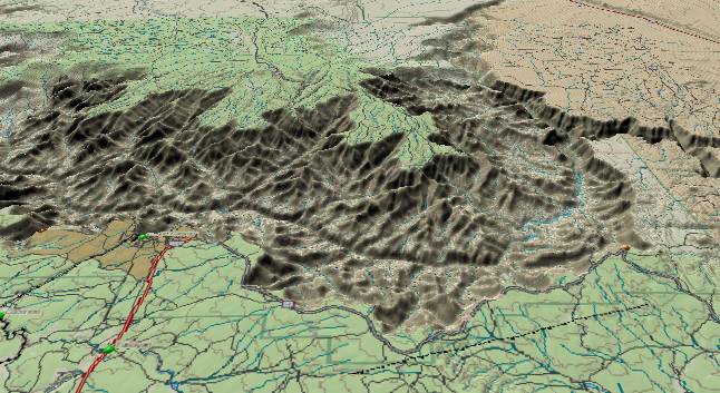
Erosion along the
Bright Angel Fault has caused Bright Angel Canyon which can be
seen on the far side of the Grand Canyon - slightly left of
the center of the picture. The Bright Angel Fault continues
south-southwestward to the South Rim where it cuts through the
visitor area at Grand Canyon Village. The Grand Canyon
Railroad (black line) uses topographic weakness along the
fault to follow it off the lower left edge.
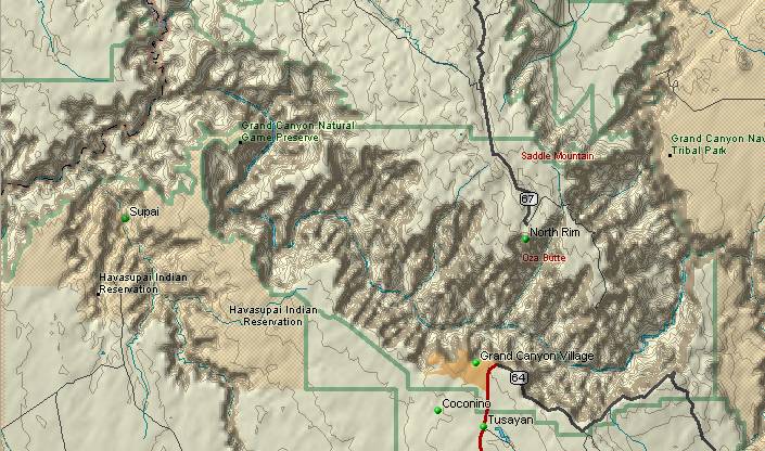
The deepest part of the Grand Canyon is found where the Colorado River cuts across the Kaibab Plateau. The South Rim (lower part of both pictures) is the area most people visit. To the east of the plateau, the Colorado River flows southward through the Marble Canyon section. The Little Colorado River (extreme right edge of both pictures) joins the main river just before the Colorado turns west through the plateau.
Kanab Creek flows southward to join the Colorado on the west side of the plateau and another tributary, Havasu (Cataract) Creek, flows northward in the lower left corner. One of the clues to the origin of the canyon can be observed on the west side of the plateau where the river is almost parallel to the contour lines.
The contour lines on the west side of the Kaibab Plateau tell us that the topography was different when the path across the Kaibab was first established. If water exists on a slope, then it will normally flow downhill at right angles to the contour lines. Here the river is almost parallel to the contour lines. (Can be seen on both sides of the canyon away from the river.) The path of the river on the west side of the plateau is a record from an earlier age when downhill was northwestward toward the top of the page instead of today's down to the southwest. This old topography has been altered by more recent uplifts, but the Grand Canyon is telling us a story. All we have to do is learn how to listen.
During the late Cretaceous (about 70 million years ago), the ancestral Little Colorado River flowed west-northwest through Mesozoic sediments directly above today's route between the north and south rims. From the Kanab Creek junction the ancestral Little Colorado continued north into Utah. The first uplift of the plateau occurred in Laramide time, and the ancestral Little Colorado cut a canyon in the Mesozoic sediments. There was a second uplift of the plateau in early Oligocene/late Eocene time (35 to 45 million years ago). The Little Colorado abandoned the ancestral canyon but continued to flow northward to the east of the Kaibab Plateau. However the ancestral canyon remained as a low area crossing the Kaibab.
During the mid Miocene (15 to 20 million years ago), the Hualapai River (another ancestral drainage system) established a path from Kanab Creek to the Grand Wash Cliffs. About 10 million years ago, the rising Wasatch Ranges in Utah started to block the ancestral Colorado River's westward course across Utah. The backup system that formed behind the Wasatch bottleneck extended from northwest Colorado into eastern Arizona. About 5.4 million years ago the backup system overflowed through the ancestral canyon across the Kaibab, and the Colorado River established its current path. From Kanab Creek, the Colorado used the path established earlier by the Hualapai to continue westward to the Grand Wash Cliffs. A third uplift of the Kaibab Plateau has occurred in the last 5 million years.
The above 2-D topographic
map shows the Kaibab Plateau with contour lines at 250
foot intervals.
The deepest part of the Grand Canyon is found where the Colorado River cuts across the Kaibab Plateau. The South Rim (lower part of both pictures) is the area most people visit. To the east of the plateau, the Colorado River flows southward through the Marble Canyon section. The Little Colorado River (extreme right edge of both pictures) joins the main river just before the Colorado turns west through the plateau.
Kanab Creek flows southward to join the Colorado on the west side of the plateau and another tributary, Havasu (Cataract) Creek, flows northward in the lower left corner. One of the clues to the origin of the canyon can be observed on the west side of the plateau where the river is almost parallel to the contour lines.
The contour lines on the west side of the Kaibab Plateau tell us that the topography was different when the path across the Kaibab was first established. If water exists on a slope, then it will normally flow downhill at right angles to the contour lines. Here the river is almost parallel to the contour lines. (Can be seen on both sides of the canyon away from the river.) The path of the river on the west side of the plateau is a record from an earlier age when downhill was northwestward toward the top of the page instead of today's down to the southwest. This old topography has been altered by more recent uplifts, but the Grand Canyon is telling us a story. All we have to do is learn how to listen.
For those who don't want
to read the whole story of how the canyon was formed,
here is a brief outline.
During the late Cretaceous (about 70 million years ago), the ancestral Little Colorado River flowed west-northwest through Mesozoic sediments directly above today's route between the north and south rims. From the Kanab Creek junction the ancestral Little Colorado continued north into Utah. The first uplift of the plateau occurred in Laramide time, and the ancestral Little Colorado cut a canyon in the Mesozoic sediments. There was a second uplift of the plateau in early Oligocene/late Eocene time (35 to 45 million years ago). The Little Colorado abandoned the ancestral canyon but continued to flow northward to the east of the Kaibab Plateau. However the ancestral canyon remained as a low area crossing the Kaibab.
During the mid Miocene (15 to 20 million years ago), the Hualapai River (another ancestral drainage system) established a path from Kanab Creek to the Grand Wash Cliffs. About 10 million years ago, the rising Wasatch Ranges in Utah started to block the ancestral Colorado River's westward course across Utah. The backup system that formed behind the Wasatch bottleneck extended from northwest Colorado into eastern Arizona. About 5.4 million years ago the backup system overflowed through the ancestral canyon across the Kaibab, and the Colorado River established its current path. From Kanab Creek, the Colorado used the path established earlier by the Hualapai to continue westward to the Grand Wash Cliffs. A third uplift of the Kaibab Plateau has occurred in the last 5 million years.
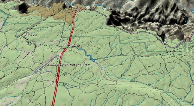
Contour
intervals 100 feet. The above picture shows the South
Rim near the main visitor area. It also traces the
path of Coconino Wash from the lower right corner to
where it exits the picture above the center of the
left edge. From a tourist point of view, Coconino Wash
isn’t much to look at, but it is of considerable
geologic interest. First, Coconino Wash ignores the
overall downward slope which is toward the lower left
corner (toward the southwest). It also ignores an
erosional weakness zone along the Bright Angel Fault
(SSW to NNE railroad track near the left edge), and
instead continues its path to the west-northwest on
the far side of the fault. (Other minor tributary
washes also defy the slope and the Bright Angel
Fault.)
Coconino Wash is thus ancestral to both the current topographic tilt and the Bright Angel Fault. It is a remnant of early Tertiary topography when downhill was toward the west-northwest. In all probability it was a tributary to the ancestral Little Colorado River (L.C.R.) which was also flowing west-northwestward a little further to the north. Instead of turning south off the left edge as it does now, this ancestral version of Coconino Wash turned north to join the ancestral L.C.R. at the present location of Hermit Canyon. (Upper left corner)
During subsequent uplifts of the Kaibab Plateau, Coconino Wash did not have the erosive power to cut a major canyon to preserve the old path. Thus at the west end, Coconino Wash abandoned the old connection to the ancestral L.C.R. and turned southward to follow the new surface tilt. However, a small local drainage inherited the local connection to the ancestral L.C.R. This is now Hermit Canyon which is one of the largest “Nick points” in the South Rim portion of the Kaibab Plateau. (Note: On the South Rim to the south of Hermits Rest, minor tributary washes still hook in to Hermit Canyon as part of this old drainage system.)
Also please see: The Kaibab Plateau http://www.durangobill.com/PaleoAppendPart9.html
Return to the Image Index Page
Web page generated via Sea Monkey's Composer HTML editor
within a Linux Cinnamon Mint 18 operating system.
(Goodbye Microsoft)