
Durango Bill's
Paleogeography (Historical Geology) Research
Evolution of the Colorado River and its Tributaries
by
Bill Butler
Evolution of the Colorado River and its Tributaries
including Formation and Origin of the Grand Canyon
Geologic History of the Grand Canyon
New Mexico Drainage During the Eocene
Steven M. Cather has
submitted a manuscript to the “The Geology of New Mexico” that
has a sharply different drainage system for the San Juan Basin
as of ~49 million years ago. Figure 23 in his manuscript shows
that drainage to the south and east of a line extending
westward from Chama, NM to Durango, CO to the Four Corners to
Gallup, NM as part of a San Juan drainage system that flowed
southeastward to Cuba, NM, then southward to the south end of
the Nacimiento Uplift, and then eastward to the north of
Albuquerque continuing east to the Texas border.
The picture below illustrates how the Rio Gallina cuts from west to east into rising strata. The resulting canyon is over 1,000 feet deep.
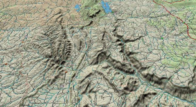
There are several reasons Mr. Cather’s model appears improbable. 1) On the north end of the Nacimiento Uplift there are three streams (including the Rio Gallina) that flow from the west (downthrown side of the uplift) to the east (into the upthrown side). The ancestors of these streams had to be in place before the uplift (65/70 million years ago), and this west to east flow had to be continuously in place from 70 million years ago to the present. This is directly in the path of “The Geology of New Mexico” diagram that shows a NNE to SSW flow from Chama, NM to Cuba, NM across the same area. 2) The NW to SE stream flow pattern from Farmington, NM to Cuba, NM would require an up strata stream flow. No mechanism is given to explain a reversal to derive the current flow pattern from the Continental Divide (just NW of Cuba) back to Farmington. 3) The diagram shows stream flow from Mesa Verde National Park toward the east. There is no sign of this flow direction in any of today’s streams. 4) The flow pattern indicates drainage from Cuba, NM turned east around the south end of the Nacimiento Uplift, and then continued east to the north of Albuqueque. The Rio Puerco, which currently drains out of Cuba, NM does not turn east (into the Rio Grande rift), but instead continues south until it joins the present Rio Grande some 50 miles south of Albuqueque. In fact the Rio Puerco drainage looks much older than the current flow pattern around the Nacimiento
The model given in this paper uses the following evidence. The 50-55 million year old San Jose Formation is found at elevations above 8,000 feet on Bridge Timber Mountain 10 miles to the southwest of Durango, CO. This shows two things. First, 50 million years ago the top of Bridge Timber Mountain was at low elevations at the northwest end of the San Juan Basin. Second, it has undergone significant uplift since then. Logically, drainage from the San Juan Basin would be expected to head for the nearest low elevation. It is 170 miles from Bridge Timber Mountain to the Tavaputs (via the previously described route.) This is much shorter than traipsing across the entire state of New Mexico. The Dolores River (and its Lost Canyon Creek tributary) appear to be part of a very old drainage system, and exactly define this expected route.
Return to Part 2 of the Evolution of the Colorado River and its Tributaries
Web page generated via Sea Monkey's Composer HTML editor
within a Linux Cinnamon Mint 18 operating system.
(Goodbye Microsoft)
The picture below illustrates how the Rio Gallina cuts from west to east into rising strata. The resulting canyon is over 1,000 feet deep.
There are several reasons Mr. Cather’s model appears improbable. 1) On the north end of the Nacimiento Uplift there are three streams (including the Rio Gallina) that flow from the west (downthrown side of the uplift) to the east (into the upthrown side). The ancestors of these streams had to be in place before the uplift (65/70 million years ago), and this west to east flow had to be continuously in place from 70 million years ago to the present. This is directly in the path of “The Geology of New Mexico” diagram that shows a NNE to SSW flow from Chama, NM to Cuba, NM across the same area. 2) The NW to SE stream flow pattern from Farmington, NM to Cuba, NM would require an up strata stream flow. No mechanism is given to explain a reversal to derive the current flow pattern from the Continental Divide (just NW of Cuba) back to Farmington. 3) The diagram shows stream flow from Mesa Verde National Park toward the east. There is no sign of this flow direction in any of today’s streams. 4) The flow pattern indicates drainage from Cuba, NM turned east around the south end of the Nacimiento Uplift, and then continued east to the north of Albuqueque. The Rio Puerco, which currently drains out of Cuba, NM does not turn east (into the Rio Grande rift), but instead continues south until it joins the present Rio Grande some 50 miles south of Albuqueque. In fact the Rio Puerco drainage looks much older than the current flow pattern around the Nacimiento
The model given in this paper uses the following evidence. The 50-55 million year old San Jose Formation is found at elevations above 8,000 feet on Bridge Timber Mountain 10 miles to the southwest of Durango, CO. This shows two things. First, 50 million years ago the top of Bridge Timber Mountain was at low elevations at the northwest end of the San Juan Basin. Second, it has undergone significant uplift since then. Logically, drainage from the San Juan Basin would be expected to head for the nearest low elevation. It is 170 miles from Bridge Timber Mountain to the Tavaputs (via the previously described route.) This is much shorter than traipsing across the entire state of New Mexico. The Dolores River (and its Lost Canyon Creek tributary) appear to be part of a very old drainage system, and exactly define this expected route.
Return to Part 2 of the Evolution of the Colorado River and its Tributaries
Web page generated via Sea Monkey's Composer HTML editor
within a Linux Cinnamon Mint 18 operating system.
(Goodbye Microsoft)