
Durango Bill's
Paleogeography (Historical Geology) Research
Appendix to the Evolution of the Colorado River and its Tributaries (Part 9)
The Kaibab Plateau
by
Bill Butler
If primary control
of the Colorado River can be attributed to any single
geographic feature in the southwestern U.S., that feature is
the Kaibab Plateau. It has also produced the most controversy
of any geographical feature. The great mystery involves how
the Colorado River got across the plateau to form the Grand
Canyon.
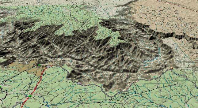
View of the main
portion of the Grand Canyon where it cuts across the Kaibab
Plateau. For additional information on the Kaibab Plateau
please see http://www.durangobill.com/Kaibab.html
John Wesley Powell led the first party through the Grand Canyon in 1869. Powell was an accomplished geologist - perhaps even better than we think. Powell concluded that the Grand Canyon was a result of the river being in place first, the Kaibab Plateau later rose, but the river was entrenched and cut the canyon. Everyone was satisfied, as now we thought we knew how the canyon was formed. Later it was “determined” that the Kaibab Plateau was uplifted in Laramide time and everyone was even happier because now we thought we knew when it was formed. Starting in the 1930’s evidence began to accumulate that perhaps the plateau had risen before the Colorado River arrived. By the 1960’s, this evidence became overwhelming, and it was concluded that the Kaibab Plateau had been uplifted before the Colorado River crossed it. Since then, there has been continuing chaotic disagreement among geologists of the world as they try to formulate a coherent theory as to how the Colorado River got across the Kaibab Plateau.
The prevailing theory during the 1970’s and 1980’s was the Colorado River flowed southward on the eastern side of the Kaibab Plateau and was eventually captured by a pirate stream eroding through from the western side. This theory has been generally discredited as covered in other sections in this website.
There have been multiple other theories trying to explain how the Colorado River got across the plateau. A more recent theory assumed the Colorado (or an ancestor that subsequently captured the Colorado) always crossed the Kaibab, but until 5.4 million years ago, continued northwestward to some unknown destination. According to this assumption an ancestral river developed in a strike valley that crossed the Kaibab Plateau in sediments directly above today’s canyon. If this scenario were true, then at some point in the past some 3,000 feet of sediments would be required both to the east and to the west of the Kaibab. This would then leave the Kaibab as a low point where the river could cross. If this hypothesis were true then we would have to erode these 3,000 feet of sediments away from the two sides while leaving the Kaibab free from erosion to produce today’s topography. This seems implausible, especially since we have already seen there has been little erosion from the Esplanade surface in the western canyon since Oligocene time. On the east side of the Kaibab, the Bidahochi Formation indicates elevations have stayed below 6,300 feet for at least the last 16 million years. Finally, we have already shown there is no evidence of a river continuing to the northwest on the west side of the Kaibab.
All of the current theories concerning the origin of the canyon seem to have a fixation that the only uplift of the Kaibab Plateau occurred during the Laramide some 65 to 70 million years ago. It is then assumed the plateau has been static ever since (relative to areas east and west of it). With a little arithmetic and some common sense, we can show that this leads to an insurmountable contradiction, and thus there has to be more than one uplift of the plateau. For the following analysis, we will use today’s elevations as relative measurements and ignore the fact the whole southwestern U. S. has risen thousands of feet as a unit.
In the chronology section, we calculated that the Kaibab Limestone would be at 7,700 feet above sea level directly over the deepest part of the gorge where the Colorado River cuts through the crest of the Kaibab Plateau. To get the total height of the plateau in Laramide time we would also have to restore all the Mesozoic sediments that were originally here. Since these were 4,000 to 5,000 feet thick, the surface elevation of the plateau would have been about 12,000 feet when it was first uplifted. This original 12,000-foot elevation would have gradually eroded down to today’s 7,700 feet (as measured by the current rims). The Colorado River (or its ancestor) would have originally crossed at an elevation somewhere in between these extremes.
If we look at the upper end of the Colorado River’s drainage today, we note that one of its tributaries is the Yampa River in Colorado. (Note: the Green River is a middleman). If we start from Craig, CO on the Yampa River, and then follow topographic maps north into Wyoming and then eastward across Wyoming, we note there are broad areas that never exceed 7,000 feet. This area has had little erosion since the early Tertiary and hence has never been above 7,000 feet. We then ask: Why did the Yampa and its downstream contributors flow hundreds of miles to get over something that had a minimum elevation of 7,700 feet when an alternate route that never exceeded 7,000 feet was always available? There is no logical answer to this question.
The only resolution to this contradiction is that at some point in the past a lower elevation was available to get across the Kaibab. This of course requires at least a second uplift for the Kaibab to reach today’s elevations. The argument that the Kaibab’s total uplift was confined to the Laramide is thus false.
Throughout this paper, we have used a breakpoint elevation of 6,300 feet as the key to crossing the Kaibab. This is based on deposits in the Bidahochi Formation that covers large areas of eastern Arizona. The lower layers of the Bidahochi are mixed lake and stream deposits while upper layers are mostly stream and wind blown layers.
The Hopi Buttes Volcanic Field strongly indicates the top of this stack was at about 6,300 feet. Volcanic activity in the Hopi Buttes was still active during the critical time period of 5 to 6 million years ago. Elevations below 6,300 feet contain dikes and sills. These are underground intrusions. Elevations above 6,300 feet are characterized by cinder cones and surface lava flows. Hence, the surface elevation was 6,300 feet. This is only 100 miles to the ESE of where the Colorado River crosses the Kaibab Plateau. At that time the whole area was very flat. Hence we can conclude that the crossing point on the Kaibab Plateau was about 6,300 feet above sea level at the critical time period 5.4 million years ago. (All of this is relative to the current elevation of the Hopi Buttes.)
We have used this elevation as a stable reference point although we should keep in mind that there are very few locations in the southwest U.S. that can be reliably identified as stable. Papers presented at the Grand Canyon Symposium 2000 imply this reference elevation is about as stable and reliable as any location in the southwestern U. S.
There is still another loose end or two that has to be resolved before the story of the Kaibab Plateau is complete. U. S. Highway 89 from Kanab, Utah east to Page, AZ curves around the north end of the Kaibab Plateau. If you track elevations via topo maps, the highest elevation the highway reaches is about 5,690 feet. (A short distance to the east of the highway, the saddle can be crossed at 5,630 feet.) Since this is significantly lower than the overflow elevation of 6,300 feet, we might wonder why the Colorado River didn’t find an easier overflow route here.
U.S. Highway 89 reaches this maximum elevation of about 5,690 feet as it traverses a valley bounded by the north end of the Kaibab Plateau to the southeast and the Vermilion Cliffs less than five miles to the northwest. The Vermilion Cliffs rise to over 6,500 feet. Since the cliffs are retreating northwestward due to erosion, we would have to restore them to the southeast if we go back in time. When the Colorado River overflowed across the Kaibab Plateau 5.4 million years ago, these cliffs completely filled the valley that is traversed by Highway 89 today.
About 5 miles further to the northeast of the high point, Highway 89 crosses Kitchen Corral Wash. The highway is still in the valley with the high Vermilion Cliffs to the northwest and the north end of the Kaibab Plateau rising over 500 feet to the southeast. Kitchen Corral Wash comes down out of the Vermilion Cliffs (no problem), but then it continues southeast right into the Kaibab Plateau. It has actually cut a deep, narrow, very young looking gorge down through the plateau; but how did it establish a path into rising terrain and strata? If we turn the clock back 5.4 million years, the valley the highway is in was still covered by the Vermilion Cliffs. The wash simply flowed southeastward on top of the cliffs and then continued southeastward over the East Kaibab Monocline (the east side of the Kaibab Plateau). As the cliffs eroded back northwestward, the stream was in place to continue cutting down through the Kaibab Limestone that caps the Kaibab Plateau.
Finally, as we follow highway 89 eastward, we descend off the Kaibab and in a few miles cross the Paria River. At the river crossing, the highway is at 4,365 feet and never climbs above 4,700 feet en route to Page, AZ. However, the Paria River takes a more southerly course to cut through a plateau more than 6,000 feet high. Why doesn’t the Paria River take the easier route? We again go back 5.4 million years.
5.4 million years ago, the broad valley had only eroded down to about 6,000 feet above sea level. Subsequently, this portion of the valley was covered by silt flats. When the Colorado River overflowed across the Kaibab, the Paria River happened to be on top of what is now the Paria Plateau. The river became entrenched and has cut a deep canyon down through the Navajo Sandstone (and subsequent lower areas). U.S. Highway 89 on the other hand crosses the easily eroded Carmel Formation. Ordinary desert cloudbursts can erode it. However, the river didn’t know this before it became entrenched so it is stuck in Paria Canyon. (Also please see http://www.durangobill.com/PariaCanyon.html)
In the chronology section, we covered the three uplifts of the Kaibab that are required to produce the Grand Canyon. The summary of events since the Cretaceous is as follows. The ancestral Little Colorado was here first. Then, the Kaibab Plateau underwent the Laramide uplift and the Little Colorado cut the ancestral canyon. The Kaibab underwent a second uplift about 40 million years ago. This drove the Little Colorado further east leaving a dry abandoned canyon. The Bidahochi/Hopi Lake sediment system overflowed about 5.4 million years ago and the canyon once again had a river. Since the overflow about 5.4 million years ago, the Kaibab has had a third uplift bringing it to its present height.
We mentioned earlier that perhaps John Wesley Powell might have been a better geologist than we think. Powell assumed the river was in place first. If he had assumed “a” river was in place first, he would have nailed it. He only missed by a “Little”.
Also please see http://www.durangobill.com/Kaibab.html
Return to the Defiance Plateau, the Chuska Mountains, and Canyon de Chelly (Part 8)
Continue to a Theory for the Numerous Local Uplifts Starting with the Olgocene (Part 10)
Return to the Main Appendix Page for the Evolution of the Colorado River
Web page generated via Sea Monkey's Composer HTML editor
within a Linux Cinnamon Mint 18 operating system.
(Goodbye Microsoft)