
Durango Bill's
Paleogeography (Historical Geology) Research
Paria Canyon and Plateau, Utah and Arizona
View to the south
with contour intervals of 100 feet. Page, AZ and Lake Powell
are on the left edge. The Paria River originates in Bryce
Canyon National Park some 40 miles north-northwest of here. It
enters the view area from the lower right corner and cuts
southeastward up and across the Paria Plateau to form Paria
Canyon instead of taking an easier route eastward following
U.S. Highway 89. At the lower end of Paria Canyon the Paria
joins the Colorado River at Lees Ferry which is the “put-in”
location for Grand Canyon raft trips.
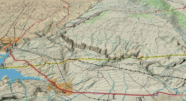
Just off the right edge, Wire Pass Canyon joins Buckskin Gulch which continues eastward just this side of the state line to eventually join the Paria. The area is characterized by narrow slot canyons and colorful patterns (ancient wind-blown sand dunes) that are exposed in the Navajo Sandstone. “The Wave” is a popular hiking/photographic destination that is fractionally off the right edge near the Arizona/Utah state line.
If you look at today’s topography, it appears the Paria should follow highway U.S. 89 down to Lake Powell and the Colorado River. If it followed this easier route, it could stay under 4,670 feet. Instead, it cuts uphill into the Paria Plateau’s rising strata and topography where contours would exceed 6,000 feet if you filled in Paria Canyon. Buckskin Gulch is already entrenched in the Paria Plateau where it first becomes visible at the right edge, and then flows eastward to join the Paria River just north (this side) of the Utah/Arizona border.
About 5.4 million years ago the Colorado River abandoned its old westward course across Utah when the rising Wasatch Ranges blocked this ancestral path. The Colorado relocated to its present course when the resulting backup system overflowed into an ancestral canyon across the Kaibab Plateau. This old canyon had been cut and abandoned by the ancestral Little Colorado River some 30 million years earlier, but the remnants of the old canyon still provided a path across the Kaibab at the 6,300-foot level. After the Colorado shifted to this new path it started cutting today’s Grand Canyon.
The area to the east of the old Wasatch route (and the new Kaibab route) was covered by a large flat valley that was in turn covered by a silt backup system. All of this area was near or above the 6,300-foot escape route of the Colorado River. This included the area shown in the picture, with everything (except the highest portions of the Paria Plateau) covered by a flat silt plain.
When the Colorado River established its path across the Kaibab Plateau, the Paria River settled into its current path circumventing the highest portions of the Paria Plateau, and oblivious to the fact there was hard Navajo Sandstone just underneath it. When canyon cutting from the Colorado worked its way back upstream, the Paria also started to cut down in its path. It quickly became stuck in a rut and ever since has continued to dig deeper into its entrenched path.
Meanwhile the surface rock along the lower edge of the picture (including the flat open area used by the highway) is the much more easily eroded Carmel Formation. There is little vegetation in this desert area, and when thunderstorms do occur, the heavy rain erodes the Carmel. The much harder Navajo Sandstone on the Paria Plateau (center and upper right of the picture) resists this rain erosion; and thus protects the high areas of the plateau. (The Navajo dips downward toward the north (foreground), and thus underlies the Carmel at the lower edge of the picture.)
Return to the Image Index Page
Web page generated via Sea Monkey's Composer HTML editor
within a Linux Cinnamon Mint 18 operating system.
(Goodbye Microsoft)
Web page generated via Sea Monkey's Composer HTML editor
within a Linux Cinnamon Mint 18 operating system.
(Goodbye Microsoft)