
Durango Bill's
Paleogeography (Historical Geology) Research
Appendix to the Evolution of the Colorado River and its Tributaries (Part 8)
The Defiance Plateau (Uplift, Upwarp), the Chuska Mountains, and Canyon de Chelly
by
Bill Butler
The Defiance Plateau
(also called Defiance Uplift and Defiance Upwarp) is of note
as it is one of the easier locations where three separate
periods of local uplift can be recognized. The area to the
southeast of Salt Lake City has also had three identifiable
periods of uplift (Sevier, Uinta, and Wasatch), but these have
been spread out over a longer time period.
The first uplift of the Defiance Plateau occurred in Laramide time. This blocked the southwest to northeast drainage from Arizona to Wyoming and helped form the ancestral Little Colorado River. The eastern boundary of the uplift was a monocline near the present Arizona / New Mexico border. The second picture (below) is a better illustration of this as the Chuska Mountains obscure the monocline at the north end. Also, there is a good photograph of the monocline on page 135 in the Fort Lewis College “Field Trip Guidebook”. Originally, drainage from the north end of the monocline was from west-southwest to east-northeast into the San Juan Basin. On the south end it appears the drainage has been from east to west, New Mexico into Arizona, since late Cretaceous time. (Again see the second picture.)
The first uplift of the Defiance Plateau occurred in Laramide time. This blocked the southwest to northeast drainage from Arizona to Wyoming and helped form the ancestral Little Colorado River. The eastern boundary of the uplift was a monocline near the present Arizona / New Mexico border. The second picture (below) is a better illustration of this as the Chuska Mountains obscure the monocline at the north end. Also, there is a good photograph of the monocline on page 135 in the Fort Lewis College “Field Trip Guidebook”. Originally, drainage from the north end of the monocline was from west-southwest to east-northeast into the San Juan Basin. On the south end it appears the drainage has been from east to west, New Mexico into Arizona, since late Cretaceous time. (Again see the second picture.)
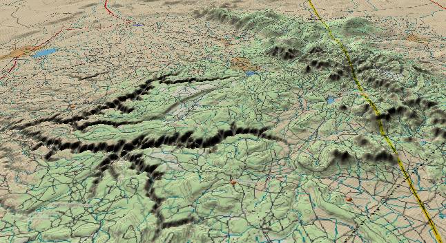
The picture above
shows the north end of the Defiance Uplift. The Chuska
Mountains run NNW to SSE along the Arizona/New Mexico border
on the right side of the picture. The canyons in Canyon de
Chelly National Monument are on the left side of the picture.
During the Oligocene (or early Miocene) the Chuska Mountains rose. The Chuskas are a narrow north-northwest to south-southeast anticline that had lots of volcanic activity as opposed to the broad dome of the original Defiance Plateau, but they illustrate that a second round of uplift can occur in a given area. The top layer in the Chuskas is composed of basaltic lava that accompanied the uplift (including a caldera where state highway 134 crosses the range at Washington Pass – off the right edge of the picture), but the underlying Chuska Sandstone had been a mystery. Recent evidence now indicates the Chuska Sandstone was deposited in the Cretaceous as opposed to the previous estimate that it was early to mid Tertiary.
Rivers and streams developed out of the new Chuska highlands, and these streams would follow the easiest paths to get to lower elevations. (The straight down the mountain rule – at right angles to topographic contour lines.) One of these streams that developed in the northern end of the Chuskas was Tsaile Creek. (Northernmost of the tributary canyons in the picture.)
Tsaile Creek flows southwestward from the highlands in the northern Chuskas until it joins Chinle Creek at the western end of Canyon de Chelly Monument. When it developed this route, the path would be straight down the mountain at right angles to the topographic lines. Then, like any mountain stream, it started to dig itself into a canyon.
If we look at a topographic map of Tsaile Creek’s course today, especially the 8 linear mile section extending from Middle Trail Canyon to Black Rock Canyon, the course is no longer at right angles to the smoothed contour lines. Tsaile Creek and its canyon now flow parallel to the contour lines. This could only happen if there was an uplift somewhere to the southeast after Tsaile Creek was embedded in its canyon. This is then the third uplift.
Thus, we have evidence of three separate local uplifts in the Defiance Plateau area. The other area that has had three uplifts is the Kaibab Plateau which we will get to in the next section.
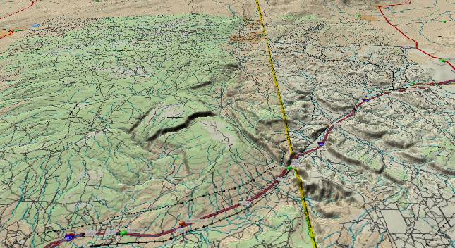
The picture above
shows the south end of the Defiance Plateau. Arizona is to the
left of the state line, and New Mexico is to the right. The
major east/west highway is I-40 with Gallup, New Mexico just
off the right edge. The smooth plateau (except for the canyon
cutting through it) near the center of the picture is the core
of the Defiance Uplift. Strata dip down to the east of it to
produce hogback ridges. Further to the east in New Mexico, the
dip is still down to the east but not as steeply. Hard
sandstone layers form abrupt cliffs on the west side, and then
dip down below surface as you progress eastward.
There are two northeast to southwest drainage systems that indicate ancestral drainage has been consistently northeast to southwest since before the Defiance Plateau was uplifted. First, as seen in the above picture, Black Creek cuts from northeast to southwest right through the core of the Defiance Uplift. Thus Black Creek was in place before the plateau rose and cut down while the plateau was rising. (Black Creek Canyon looks young implying there has been renewed uplift in this area in the recent past.) Also drainage from Gallup, New Mexico (off the right edge) flows westward through the rising strata of the Defiance Upwarp. This drainage also had to be in place before the plateau rose. Both of these streams indicate drainage in this area has been from New Mexico into Arizona since late Cretaceous time. This is another contradiction to the theory that at one time an ancestral Colorado River continued eastward out of Arizona into New Mexico.
Return to Colorado's Gore Range (Part 7)
Continue to the Kaibab Plateau (Part 9)
Return to the Main Appendix Page for the Evolution of the Colorado River
Web page generated via Sea Monkey's Composer HTML editor
within a Linux Cinnamon Mint 18 operating system.
(Goodbye Microsoft)