
Durango Bill's
Paleogeography (Historical Geology) Research
Appendix to the Evolution of the Colorado River and its Tributaries (Part 6)
Bridge Timber Mountain and the Ancestral San Juan River
by
Bill Butler
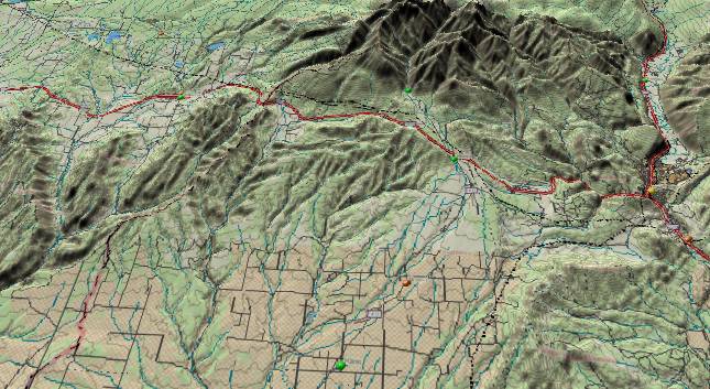
The picture above
shows the La Plata Mountains (top edge), Durango, Colorado
(right edge), and Bridge Timber Mountain (fuzzy label just
above the lower right edge). Bridge Timber Mountain rises to
over 8,300 feet some 10 to 11 miles southwest of Durango, CO.
Although this is more than 1,000 feet higher than anything
else within a span extending from 25 miles east to west of the
mountain, it is very modest by southwest Colorado standards
and would not be of interest except for a “slight” problem.
The top of the mountain as well as a ridge extending southward
from it is capped by gravel and river deposits. The question
is when and how these deposits got there.
The deposits are found on a very flat surface that tilts downward slightly east of due south. The underlying strata here contain late Cretaceous and early Tertiary sedimentary layers that dip steeply to the southeast. Hence, the flat surface represents an ancestral beveled erosion surface – not a surface due to a hard rock layer.
There are two possible scenarios for the origin of these deposits. The prevailing view is that they are outwash deposits left by the ancestral La Plata River as it flowed southward from the La Plata Mountains (Some 15 to 20 miles further north). Their age was initially estimated as Pleistocene although recent interpretations have extended the possible age range further back into the Miocene. In this interpretation, the smooth sloping surface at the summit of Bridge Timber Mountain (and continuing south southeastward along Black Ridge) is a remnant of a former outwash fan deposited by the La Plata River. At some point after the gravel was deposited, the La Plata River changed its course to flow southwestward where it is currently found some 5 to 8 miles west of the mountain. Then erosion by the La Plata River to the west and the Animas River to the east left Bridge Timber Mountain standing alone.
We would like to present another interpretation that seems to fit the evidence a little better. The very late Oligocene or early Miocene appears to be a more likely time for these deposits. However, either interpretation is possible, as it doesn’t alter the overall model. In the following discussion, the text that appears in quotes is taken from page 167 “Field Trip Guidebook” compiled by the Fort Lewis College Geology Department. In turn, the guidebook refers to earlier sources.
If we look at a cross section profile (via the Topo USA program) extending from 25 miles west of Bridge Timber Mountain to 25 miles east of the mountain, we find that the mountain is more than 1,000 feet higher than any other object in this span. The terrain to the west of the mountain is extremely flat. (See the above picture.) It is flat to the point where a 30 to 1 vertical exaggeration on the cross section profile fails to reveal the location of the La Plata River. This does not seem consistent with over 1,000 feet of river erosion within the last few million years.
The surface slope of the mountain top deposit dips slightly east of due south. If the ancestral La Plata River had been here, then it should have followed this same south to south-southeast direction and joined the Animas River a few miles further downstream. Another factor that should have favored this route is prevailing strata that dip sharply to the southeast. A problem exists, as there is no recognizable mechanism to relocate the La Plata River further to the west where it now resides.
The Field Trip Guide describes the deposit as containing “a few large boulders up to 6 ft. (2 m) in length”. Boulders of this size require either a steep gradient or a large river for transport. If they came from the La Plata Mountains, the nearest high elevation (11,000 feet) is 14 linear miles away. The La Plata River has only a small source area and the water volume required to carry boulders of this size for at least 14 miles presents a problem.
The source for the deposits was assigned to the La Plata Mountains as the clasts contain various volcanic sources and the general composition is different from that currently found in the Animas River (east of the mountain). There are volcanic intrusions in the La Platas. However, there was a great deal of volcanic activity in the Silverton area some 26 to 29 million years ago. The Animas River (much larger than the La Plata) could have brought these larger boulders southward, and the most likely junction point for the ancestral San Juan and the Animas was between 2 and 5 miles to the northeast of Bridge Timber Mountain.
The Field Trip Guide also describes the deposits as having “advanced weathering” in addition to “the great height above modern streams”. This would seem to favor the late Oligocene to early Miocene time frame for these deposits.
 If we interpret the
gravels to be of very late Oligocene to early Miocene age,
then the following scenario seems to fit. The ancestral San
Juan River flowed west-northwestward from the current east end
of Navajo Lake to Ignacio, to just south of Durango, to just
north of Bridge Timber Mountain, to the minor pass at the top
of Mancos Hill, and on to the east end of McPhee Reservoir.
Since all this took place 30 million years ago, the actual
path would have been in layers that were above today’s
surface. Most of these layers have since eroded away, but the
top of Bridge Timber Mountain would still be a remnant.
If we interpret the
gravels to be of very late Oligocene to early Miocene age,
then the following scenario seems to fit. The ancestral San
Juan River flowed west-northwestward from the current east end
of Navajo Lake to Ignacio, to just south of Durango, to just
north of Bridge Timber Mountain, to the minor pass at the top
of Mancos Hill, and on to the east end of McPhee Reservoir.
Since all this took place 30 million years ago, the actual
path would have been in layers that were above today’s
surface. Most of these layers have since eroded away, but the
top of Bridge Timber Mountain would still be a remnant.
As the ancestral San Juan flowed west-northwest from Navajo Lake to the present Animas River, it eroded away overburden from the present Allison, Tiffany, Ignacio, Oxford, and “Florida Mesa” portion of its route. The overburden is still present further south in the Mesa Mountains. However, this section is conspicuously flat across an area where low mountains should exist. Removal of the overburden provided a convenient low area for outwash from the San Juan Mountains to form multiple terraces during the very late Tertiary and Quaternary.
After crossing the present Animas River, the ancestral San Juan continued west-northwest across (actually above) the current Ridges Basin. (This is a “best estimate” based on present topography.) The area west of the Animas River westward to Dolores has been uplifted some 2,000 feet since the very late Oligocene or early Miocene. (See the “La Plata Mountains, Upper Dolores River, and Ancestral San Juan River” and “The Mancos Valley Northwestward to Bishop & Summit Canyons, Southwestern Colorado” sections of this paper and the Field Trip Guidebook page 168. The Field Trip Guidebook refers to Steven, Gable, Hatton, Atwood, Mather, and Bandoian regarding this uplift but doesn’t give any clues as to the magnitude.). Thus, for the remainder of the path to McPhee Reservoir, up to 2,000 feet has to be subtracted from current elevations to restore the topography of 25 to 30 million years ago. This path is only a couple of miles north of Bridge Timber Mountain.
(Added 6/11/06) An extensive area of old river gravels exists in an area 6 to 7.5 miles WSW of Durango. This area contains large numbers of well rounded rocks up to two feet in diameter. The cobbles include what looks like quartzite, dark schist/gneiss, white quartz, and granite mixed in with other rocks. These rock types are common near the present Animas River, but are not native to the La Plata Mountains/La Plata River. Primary deposits are best exposed in the western/higher part of the zone. The best roadside example is northeast of (next to and above) the highway near 37.257 N, 108.012 W with secondary (washed down from higher levels) deposits extending east to about 37.248 N, 107.988 W. The gravels suggest that at some time in the past, the Animas River drainage went west from Durango vs. the current southerly course of the Animas River. (End of 6/11/06 addition.)
Observations reported in the Field Trip Guidebook describe the Bridge Timber deposits as “thinning rapidly from north to south”. If we assume the deposits are from the ancestral San Juan River, then it would be logical to expect rapid thinning as you travel further south away from the ancestral river. If you use the more recent La Plata River deposition model, then it becomes more difficult to explain rapid thinning on outwash deposits when you are 15 to 20 miles away from the source (the La Plata Mountains).
As noted earlier, the flat slope of the deposits is tilted slightly east of due south. If we use the ancestral San Juan model, then these deposits were laid down on a nearly flat valley floor. Then surface tilt was introduced later during the uplift stage. The greatest uplift was to the north over the La Platas with lesser amounts southward, hence the south to south-southeast tilt. (The southeastward tilt in the underlying strata is thus a composite of the original San Juan Mountain uplift, sinking of the San Juan Basin, and late Oligocene / early Miocene renewed uplift. A renewed fold downward to the east may complicate this most recent uplift. (It should be noted that the dip into the San Juan Basin at Bridge Timber Mountain (northwest side of the basin) is steeper than the dip into the basin observed on the northeastern side of the basin.))
If we compare the gradient of recent gravel deposits near the Animas River with those on top of Bridge Timber Mountain, we get another indication of a regional uplift after the Bridge Timber Gravel was deposited. A table on page 165, Field Trip Guidebook, shows the gradient in feet per mile for various gravel deposits near Durango. If we use an average of five different gravel terraces deposited over the last 600,000 years by the Animas River as measured near Bridge Timber Mountain, we get an average gradient of 35 feet per mile. The same table shows a gradient of 93 feet per mile for the Bridge Timber Gravel. This yields a difference of 58 feet per mile. If we assume that this difference was a result of an interim uplift to the north with a gradually decreasing uplift southward, and multiply by the 33 miles from B. T. Mountain to the present location of the San Juan River, we get an elevation differential of 1914 feet. This is reasonably close to the 2,000 feet of uplift that is needed to transform an ancestral San Juan River bed to today’s topography.
The Oligocene/Miocene model also allows another possibility. Since it establishes the old summit of Bridge Timber Mountain as part of the valley floor, it would still be relatively low ground for several million years after the ancestral San Juan was forced southward into New Mexico. It is possible that outwash from the La Plata Mountains by the La Plata River could have been deposited during the first few million years after the San Juan withdrew.
Another factor to consider at this point is the different composition between the Bridge Timber gravels and other deposits traceable to the Animas River. First, the ancestral San Juan River would be drawing from a different source area. More import, the Animas River could be responsible for all the deposits. Logically, if any river is going to leave two sets of gravel deposits separated by a 25 million-year time gap, the clasts (cobbles) will have eroded from different erosion levels in the mountains at the river’s source.
From the Ridges Basin area, the ancestral San Juan River continued west-northwest. The most likely path would be near or a few miles south of Hesperus to the top of Mancos Hill. (A route around the south side of the unnamed east-west ridge to the west of Hesperus seems more likely.) There are several east to west valleys in this area with the largest of these occupied by the east end of Cherry Creek. (Just above the center of the first picture.) The intervening ridges do not seem to follow the expected rules for hogback ridges. First, there are more ridges than available sandstone layers. Secondly, topographic and geologic maps imply the layers may not be turned upward at all and might be separate canyons eroded into a single Cliff House Sandstone surface. (This should be verified at some future time – unfortunately the area is remote with no highway access) Third, hogback ridges further east away from this area are parallel to the underlying Dakota Sandstone. In this area (east of Mancos Hill), the two elements form a slight angle with the ridges pointing a little south of due west while the Dakota trends more west northwestward. Finally, there is no continuation of the east/west ridge and valley pattern into the unnamed ridge south of Mancos Hill Pass or slightly further west in Menefee Mountain. All of this might be a weak hint that there may be an east to west influence by the old river pattern. Alternately it might just be hogback ridges; the evidence is inconclusive.
At the top of Mancos Hill, we find a lot of gravel and cobbles that was once part of a stream/river bed. While this could be a remnant from the ancient San Juan, a more likely source is a former (and much more recently) abandoned path of the East Mancos River. It could also be a combination. Again, there is no conclusive evidence for either scenario.
About ten miles further to the west-northwest we come to Lost Canyon Creek. Lost Canyon Creek is entrenched in a canyon that travels toward the west and west-northwest in an area where present topography (and strata) slope down to the southwest. The northeast to southwest tilt was introduced after some former drainage had been established. Thus, it has to be a fragment of an old ancestral river. It is probable that it is either a remnant of a tributary to the ancestral San Juan River or even a remnant of the ancestral San Juan. The continuation of the ancestral San Juan’s course is described in the Dolores River sections of this appendix.
The deposits are found on a very flat surface that tilts downward slightly east of due south. The underlying strata here contain late Cretaceous and early Tertiary sedimentary layers that dip steeply to the southeast. Hence, the flat surface represents an ancestral beveled erosion surface – not a surface due to a hard rock layer.
There are two possible scenarios for the origin of these deposits. The prevailing view is that they are outwash deposits left by the ancestral La Plata River as it flowed southward from the La Plata Mountains (Some 15 to 20 miles further north). Their age was initially estimated as Pleistocene although recent interpretations have extended the possible age range further back into the Miocene. In this interpretation, the smooth sloping surface at the summit of Bridge Timber Mountain (and continuing south southeastward along Black Ridge) is a remnant of a former outwash fan deposited by the La Plata River. At some point after the gravel was deposited, the La Plata River changed its course to flow southwestward where it is currently found some 5 to 8 miles west of the mountain. Then erosion by the La Plata River to the west and the Animas River to the east left Bridge Timber Mountain standing alone.
We would like to present another interpretation that seems to fit the evidence a little better. The very late Oligocene or early Miocene appears to be a more likely time for these deposits. However, either interpretation is possible, as it doesn’t alter the overall model. In the following discussion, the text that appears in quotes is taken from page 167 “Field Trip Guidebook” compiled by the Fort Lewis College Geology Department. In turn, the guidebook refers to earlier sources.
If we look at a cross section profile (via the Topo USA program) extending from 25 miles west of Bridge Timber Mountain to 25 miles east of the mountain, we find that the mountain is more than 1,000 feet higher than any other object in this span. The terrain to the west of the mountain is extremely flat. (See the above picture.) It is flat to the point where a 30 to 1 vertical exaggeration on the cross section profile fails to reveal the location of the La Plata River. This does not seem consistent with over 1,000 feet of river erosion within the last few million years.
The surface slope of the mountain top deposit dips slightly east of due south. If the ancestral La Plata River had been here, then it should have followed this same south to south-southeast direction and joined the Animas River a few miles further downstream. Another factor that should have favored this route is prevailing strata that dip sharply to the southeast. A problem exists, as there is no recognizable mechanism to relocate the La Plata River further to the west where it now resides.
The Field Trip Guide describes the deposit as containing “a few large boulders up to 6 ft. (2 m) in length”. Boulders of this size require either a steep gradient or a large river for transport. If they came from the La Plata Mountains, the nearest high elevation (11,000 feet) is 14 linear miles away. The La Plata River has only a small source area and the water volume required to carry boulders of this size for at least 14 miles presents a problem.
The source for the deposits was assigned to the La Plata Mountains as the clasts contain various volcanic sources and the general composition is different from that currently found in the Animas River (east of the mountain). There are volcanic intrusions in the La Platas. However, there was a great deal of volcanic activity in the Silverton area some 26 to 29 million years ago. The Animas River (much larger than the La Plata) could have brought these larger boulders southward, and the most likely junction point for the ancestral San Juan and the Animas was between 2 and 5 miles to the northeast of Bridge Timber Mountain.
The Field Trip Guide also describes the deposits as having “advanced weathering” in addition to “the great height above modern streams”. This would seem to favor the late Oligocene to early Miocene time frame for these deposits.
If we interpret the
gravels to be of very late Oligocene to early Miocene age,
then the following scenario seems to fit. The ancestral San
Juan River flowed west-northwestward from the current east end
of Navajo Lake to Ignacio, to just south of Durango, to just
north of Bridge Timber Mountain, to the minor pass at the top
of Mancos Hill, and on to the east end of McPhee Reservoir.
Since all this took place 30 million years ago, the actual
path would have been in layers that were above today’s
surface. Most of these layers have since eroded away, but the
top of Bridge Timber Mountain would still be a remnant.As the ancestral San Juan flowed west-northwest from Navajo Lake to the present Animas River, it eroded away overburden from the present Allison, Tiffany, Ignacio, Oxford, and “Florida Mesa” portion of its route. The overburden is still present further south in the Mesa Mountains. However, this section is conspicuously flat across an area where low mountains should exist. Removal of the overburden provided a convenient low area for outwash from the San Juan Mountains to form multiple terraces during the very late Tertiary and Quaternary.
After crossing the present Animas River, the ancestral San Juan continued west-northwest across (actually above) the current Ridges Basin. (This is a “best estimate” based on present topography.) The area west of the Animas River westward to Dolores has been uplifted some 2,000 feet since the very late Oligocene or early Miocene. (See the “La Plata Mountains, Upper Dolores River, and Ancestral San Juan River” and “The Mancos Valley Northwestward to Bishop & Summit Canyons, Southwestern Colorado” sections of this paper and the Field Trip Guidebook page 168. The Field Trip Guidebook refers to Steven, Gable, Hatton, Atwood, Mather, and Bandoian regarding this uplift but doesn’t give any clues as to the magnitude.). Thus, for the remainder of the path to McPhee Reservoir, up to 2,000 feet has to be subtracted from current elevations to restore the topography of 25 to 30 million years ago. This path is only a couple of miles north of Bridge Timber Mountain.
(Added 6/11/06) An extensive area of old river gravels exists in an area 6 to 7.5 miles WSW of Durango. This area contains large numbers of well rounded rocks up to two feet in diameter. The cobbles include what looks like quartzite, dark schist/gneiss, white quartz, and granite mixed in with other rocks. These rock types are common near the present Animas River, but are not native to the La Plata Mountains/La Plata River. Primary deposits are best exposed in the western/higher part of the zone. The best roadside example is northeast of (next to and above) the highway near 37.257 N, 108.012 W with secondary (washed down from higher levels) deposits extending east to about 37.248 N, 107.988 W. The gravels suggest that at some time in the past, the Animas River drainage went west from Durango vs. the current southerly course of the Animas River. (End of 6/11/06 addition.)
Observations reported in the Field Trip Guidebook describe the Bridge Timber deposits as “thinning rapidly from north to south”. If we assume the deposits are from the ancestral San Juan River, then it would be logical to expect rapid thinning as you travel further south away from the ancestral river. If you use the more recent La Plata River deposition model, then it becomes more difficult to explain rapid thinning on outwash deposits when you are 15 to 20 miles away from the source (the La Plata Mountains).
As noted earlier, the flat slope of the deposits is tilted slightly east of due south. If we use the ancestral San Juan model, then these deposits were laid down on a nearly flat valley floor. Then surface tilt was introduced later during the uplift stage. The greatest uplift was to the north over the La Platas with lesser amounts southward, hence the south to south-southeast tilt. (The southeastward tilt in the underlying strata is thus a composite of the original San Juan Mountain uplift, sinking of the San Juan Basin, and late Oligocene / early Miocene renewed uplift. A renewed fold downward to the east may complicate this most recent uplift. (It should be noted that the dip into the San Juan Basin at Bridge Timber Mountain (northwest side of the basin) is steeper than the dip into the basin observed on the northeastern side of the basin.))
If we compare the gradient of recent gravel deposits near the Animas River with those on top of Bridge Timber Mountain, we get another indication of a regional uplift after the Bridge Timber Gravel was deposited. A table on page 165, Field Trip Guidebook, shows the gradient in feet per mile for various gravel deposits near Durango. If we use an average of five different gravel terraces deposited over the last 600,000 years by the Animas River as measured near Bridge Timber Mountain, we get an average gradient of 35 feet per mile. The same table shows a gradient of 93 feet per mile for the Bridge Timber Gravel. This yields a difference of 58 feet per mile. If we assume that this difference was a result of an interim uplift to the north with a gradually decreasing uplift southward, and multiply by the 33 miles from B. T. Mountain to the present location of the San Juan River, we get an elevation differential of 1914 feet. This is reasonably close to the 2,000 feet of uplift that is needed to transform an ancestral San Juan River bed to today’s topography.
The Oligocene/Miocene model also allows another possibility. Since it establishes the old summit of Bridge Timber Mountain as part of the valley floor, it would still be relatively low ground for several million years after the ancestral San Juan was forced southward into New Mexico. It is possible that outwash from the La Plata Mountains by the La Plata River could have been deposited during the first few million years after the San Juan withdrew.
Another factor to consider at this point is the different composition between the Bridge Timber gravels and other deposits traceable to the Animas River. First, the ancestral San Juan River would be drawing from a different source area. More import, the Animas River could be responsible for all the deposits. Logically, if any river is going to leave two sets of gravel deposits separated by a 25 million-year time gap, the clasts (cobbles) will have eroded from different erosion levels in the mountains at the river’s source.
From the Ridges Basin area, the ancestral San Juan River continued west-northwest. The most likely path would be near or a few miles south of Hesperus to the top of Mancos Hill. (A route around the south side of the unnamed east-west ridge to the west of Hesperus seems more likely.) There are several east to west valleys in this area with the largest of these occupied by the east end of Cherry Creek. (Just above the center of the first picture.) The intervening ridges do not seem to follow the expected rules for hogback ridges. First, there are more ridges than available sandstone layers. Secondly, topographic and geologic maps imply the layers may not be turned upward at all and might be separate canyons eroded into a single Cliff House Sandstone surface. (This should be verified at some future time – unfortunately the area is remote with no highway access) Third, hogback ridges further east away from this area are parallel to the underlying Dakota Sandstone. In this area (east of Mancos Hill), the two elements form a slight angle with the ridges pointing a little south of due west while the Dakota trends more west northwestward. Finally, there is no continuation of the east/west ridge and valley pattern into the unnamed ridge south of Mancos Hill Pass or slightly further west in Menefee Mountain. All of this might be a weak hint that there may be an east to west influence by the old river pattern. Alternately it might just be hogback ridges; the evidence is inconclusive.
At the top of Mancos Hill, we find a lot of gravel and cobbles that was once part of a stream/river bed. While this could be a remnant from the ancient San Juan, a more likely source is a former (and much more recently) abandoned path of the East Mancos River. It could also be a combination. Again, there is no conclusive evidence for either scenario.
About ten miles further to the west-northwest we come to Lost Canyon Creek. Lost Canyon Creek is entrenched in a canyon that travels toward the west and west-northwest in an area where present topography (and strata) slope down to the southwest. The northeast to southwest tilt was introduced after some former drainage had been established. Thus, it has to be a fragment of an old ancestral river. It is probable that it is either a remnant of a tributary to the ancestral San Juan River or even a remnant of the ancestral San Juan. The continuation of the ancestral San Juan’s course is described in the Dolores River sections of this appendix.
Return to the Mancos Valley
Northwestward to Bishop and Summit Canyons (Part 5)
Continue to Colorado's Gore Range (Part 7)
Return to the Main Appendix Page for the Evolution of the Colorado River
Web page generated via Sea Monkey's Composer HTML editor
within a Linux Cinnamon Mint 18 operating system.
(Goodbye Microsoft)
Continue to Colorado's Gore Range (Part 7)
Return to the Main Appendix Page for the Evolution of the Colorado River
Web page generated via Sea Monkey's Composer HTML editor
within a Linux Cinnamon Mint 18 operating system.
(Goodbye Microsoft)