
Durango Bill's
Paleogeography (Historical Geology) Research
Appendix to the Evolution of the Colorado River and its Tributaries (Part 3)
La Plata Mountains, Upper Dolores River, and Ancestral San Juan River
by
Bill Butler
The history of the La Plata Mountains and nearby terrain to the south and west is significant as it controls the history of the San Juan River as well as local features near Durango. The first uplift of the La Platas resulted from igneous intrusions 65 to 70 million years ago, but was local in extent and had little influence on river paths. A second uplift seems to have occurred during the Oligocene and early Miocene. While this second event lifted the La Platas still higher, it was more widespread horizontally. There appears to have been local centers of uplift in the La Platas and the Wilson Peaks, a moderate uplift extending westward into eastern Utah (with another intrusion uplift in the Abajos), and a gradually diminishing amount of uplift extending southward into New Mexico. This uplift is what drove the ancestral San Juan River southward into New Mexico.
Now, let’s look into the details of the San Juan’s ancestral course. In-between its source northeast of Pagosa Springs and Arboles (on the north side of Navajo Lake), the San Juan River looks like it has maintained the same path ever since the eastern San Juan Mountains were first uplifted. This anchors the historical course of the river upstream from Navajo Lake.
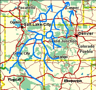 In the early Tertiary,
all drainage systems west of the Rockies headed north toward
Lake Uinta, and then continued northeastward into Wyoming.
Thus, in the Eocene, the logical destination for the ancestral
San Juan would lead to these Lake Uinta lowlands in northeast
Utah. The ancestral river would naturally try to take the
shortest, easiest path between the present Navajo Lake and
this ancient meeting point. If we draw a straight line between
the two end points, the middle portion of this path would lead
over the top of the San Juan Mountains. So much for the
straight-line theory. The next easiest possible path for the
river would be to flow westward around the south side of the
San Juan Mountains and then turn north. This is the area we
will look at to determine the old path.
In the early Tertiary,
all drainage systems west of the Rockies headed north toward
Lake Uinta, and then continued northeastward into Wyoming.
Thus, in the Eocene, the logical destination for the ancestral
San Juan would lead to these Lake Uinta lowlands in northeast
Utah. The ancestral river would naturally try to take the
shortest, easiest path between the present Navajo Lake and
this ancient meeting point. If we draw a straight line between
the two end points, the middle portion of this path would lead
over the top of the San Juan Mountains. So much for the
straight-line theory. The next easiest possible path for the
river would be to flow westward around the south side of the
San Juan Mountains and then turn north. This is the area we
will look at to determine the old path.We can divide this old path into two segments. Segment one examines Navajo Lake to Dolores. Segment two looks at the section starting at Dolores and continuing northward. Segment two will be examined later. In this portion, we will concentrate on how the river was able to travel from Navajo Lake to Dolores.
First, we draw a straight line between Navajo Lake and Dolores and note that it passes just south of Durango. All other things being equal, the river would try to follow this shortest path. The first half extends from Navajo Lake to just south of Durango. This area is flat and it doesn’t require much imagination to picture it as a river basin from long ago. (Outwash from the San Juan Mountains over the last few million years has deposited terraces across this old river basin.) From the Animas River west northwestward, there is a “slight” uphill problem. You have to climb about 2,000 feet to get over all the intervening mountains. There doesn’t appear to be any better alternate path, thus we’ll look for evidence that this route was lower 30 to 50 million years ago which would allow the river to continue west northwestward. An alternate way of expressing this is to find evidence that west of Durango there has been 2,000 feet of uplift during the last 30 million years.
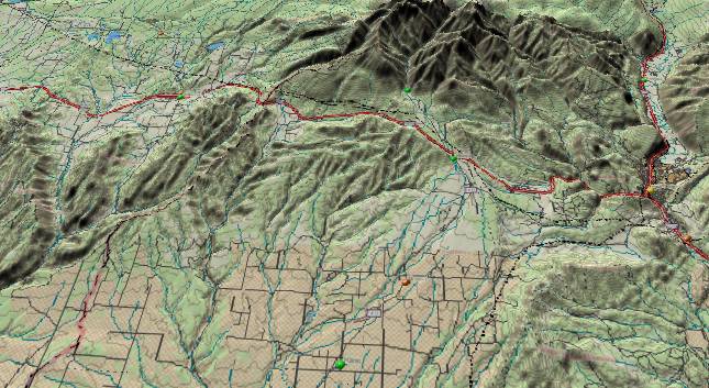
Since the most likely route passes a short distance south of the La Plata Mountains, much of the following observations that are focussed on the La Platas will also apply to the old river route. (Please also refer to the La Plata Mountains 3-D map.) As we have noted, the mid-Tertiary uplifts appear to be regional and extended over a broad area.
There are several pieces of evidence that indicate the La Platas didn’t reach their current height until the Miocene. First, we note that the Dakota Sandstone is still present at altitudes of 13,000 feet in the La Platas. (See Ogden Tweto’s geologic map.) No other mountain range in Colorado has preserved the Dakota at this altitude. The closest competition is found at altitudes above 11,000 feet in the area around the Lizard Head Mountains – and here the Dakota was protected by Tertiary volcanics and was not lifted to present heights until mid/late Tertiary time. On the high peaks of the Front Range (which dates from late Cretaceous time) not only has the Dakota Sandstone eroded away, but the rest of the Mesozoic layers are also long gone. The implication is that these layers should have been eroded from the La Plata Mountains if they had been exposed at their present high elevations for 60+ million years.
The second argument for a more recent age for their final uplift is mineral deposits (gold, silver, etc.). The nearby mineral deposits further north in the San Juan Mountains were Miocene hydrothermal deposits. Gold and silver deposits also exist at elevations up to 12,000 feet in the La Plata Mountains. The Field Trip Guidebook (see page 22) states that “Most ore deposits (in the La Platas) are in veins.” implying similar hydrothermic origin, but does not give any date for them. If the La Platas had been uplifted to their present height in the late Cretaceous – early Tertiary period, then some other earlier mineralization process would be needed as it would be difficult to push hot ground water to 12,000 feet in an isolated mountain cluster.
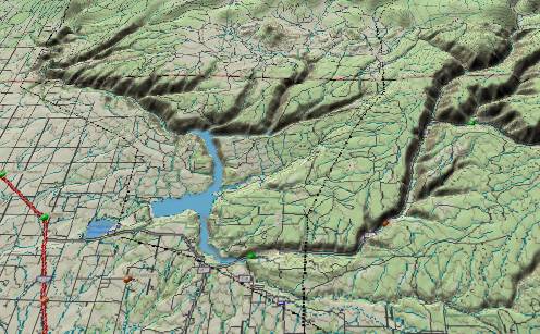
There is a northeast to southwest fault that passes through McPhee Reservoir (just northwest of Dolores). The maximum offset is on the southeast side with an uplift of about 500 feet. There is only limited erosion along the scarp implying it is of relatively recent origin. The highest peak in the La Plata Mountains is 20 miles east-southeast of the maximum offset area. The route that the ancient San Juan would have followed is about 10 miles further south.
 The West Dolores River
and the main river below The Forks (near Stoner) also indicate
there was significant uplift in the La Plata Mountains long
after the river was in place. The Dolores River downstream
from The Forks shows the north-northeast to south-southwest
pattern that is typical of other rivers on the south side of
the San Juan Mountains. This would reflect the “straight down
the hillside” rule that was in effect after the first uplift
of the San Juan Mountains. The contour lines on current
topographic maps show contours currently run north-northwest
to south-southeast across the Dolores River below Stoner.
(Please refer to the Dolores River
3-D map.) This would dictate an east-northeast to
west-southwest path for the river if it established its course
by today’s “straight down the hillside” topography. Thus, the
current path of the river cuts diagonally across the contour
lines. The conclusion that we can gather is that the river
established its course when “straight down the mountain” was
toward the south-southwest, and a subsequent uplift at some
distance to the east-southeast has altered the contour lines.
We also note the La Plata Mountains are about 15 miles
east-southeast of this portion of the river. (Surface rock in
this area is the Dakota Sandstone, and all the contour line
arguments also apply to this rock layer.)
The West Dolores River
and the main river below The Forks (near Stoner) also indicate
there was significant uplift in the La Plata Mountains long
after the river was in place. The Dolores River downstream
from The Forks shows the north-northeast to south-southwest
pattern that is typical of other rivers on the south side of
the San Juan Mountains. This would reflect the “straight down
the hillside” rule that was in effect after the first uplift
of the San Juan Mountains. The contour lines on current
topographic maps show contours currently run north-northwest
to south-southeast across the Dolores River below Stoner.
(Please refer to the Dolores River
3-D map.) This would dictate an east-northeast to
west-southwest path for the river if it established its course
by today’s “straight down the hillside” topography. Thus, the
current path of the river cuts diagonally across the contour
lines. The conclusion that we can gather is that the river
established its course when “straight down the mountain” was
toward the south-southwest, and a subsequent uplift at some
distance to the east-southeast has altered the contour lines.
We also note the La Plata Mountains are about 15 miles
east-southeast of this portion of the river. (Surface rock in
this area is the Dakota Sandstone, and all the contour line
arguments also apply to this rock layer.)The West Dolores River also has evidence of more recent La Plata uplift. Two tributaries to the West Dolores (Groundhog Creek and Cottonwood Creek) flow southeastward into rising strata and rising topography. (The present smoothed topographic contours show a rise of over 1,000 vertical feet for both streams before they reach the West Dolores.). These streams had to flow downhill when they were initially established. The rising terrain and new tilt had to come after the streams established their courses allowing them to cut into the upward tilting terrain. The southeastward upward tilt points in the general direction of the La Platas.
The McDermott Member of the Animas Formation is probably best exposed a few miles south-southeast of Durango on the southwest side of the Animas River just across from Wal-Mart. The McDermott is a sedimentary layer with volcanic debris that may have been associated with volcanic activity in the La Platas. In any case, its age is about Paleocene time (Field Trip Guidebook). Since it is sedimentary, it presumably was nearly level when it was deposited. Recent evidence indicates the McDermott may be one or more “lahars”. A lahar is a thick gooey mudflow frequently composed of volcanic ash mixed with water. It also may contain anything else that had the misfortune to be in its path. Lahars don’t have to form horizontal surfaces when they come to rest although a tilted final surface would be relatively rare.
The McDermott is also found eastward out to the Florida River and southward to near the New Mexico border. These horizontal distances are many miles from the Wal-Mart location, which brings us back to the flat surface argument. We bring this up, as it is highly probably that the McDermott did form a flat surface when it came to rest, but this is not guaranteed. If we look at the McDermott layer today (behind Wal-Mart), we note that it tilts up sharply to the northwest. If we assume it was level when it was deposited (especially after it had time to settled out after the flows), then the current tilt up to the northwest indicates it and all the other strata layers underwent uplift to the northwest sometime after it was deposited. (i.e. after the Paleocene) This northwest vector from Wal-Mart coincides with the most likely path of the ancient San Juan. Initially the San Juan’s path would have been across a flat surface, and then when uplift occurred, the San Juan would have to find a new route.
The development of the La Plata River is also dependent on the formation sequence of the La Platas. The La Plata Range itself would be an uncomplicated north-northeast to south-southwest dome except the La Plata River bisects the entire length of the range exactly where the crest of the range should be. (See the computer generated 3-D image of the La Plata Mountains.) However, we note that the orientation of the river is similar to other rivers on the south side of the San Juan Mountains.
If we continue north-northeast from the upper end of the La Plata River, we intercept another creek. The upper end of Hermosa Creek has the usual NNE-SSW orientation and is directly aligned with the La Plata River except the lower portion of Hermosa Creek is deflected southeastward by – the La Plata Mountains. Hmmm! We present the following argument as it appears to be the only feasible derivation on how and why the La Plata River is able to produce a lengthwise split of the La Plata Mountains.
At some point in the past it appears the upper end of Hermosa Creek continued south-southwest near the current location of Kennebec Pass and then SSW along the current La Plata River. Subsequently the La Platas have undergone two separate uplifts (Laramide intrusions and Oligocene). Hermosa Creek was not able to cut down fast enough to keep pace with one of these uplifts; thus, its lower portion was deflected toward the southeast. Drainage along the old path through the heart of the La Platas continued to erode downward and this portion is now the La Plata River. (The breakpoint occurred at the north end of the rising range, as this is where the strata were undergoing the maximum change in tilt.)
The deflected lower end of Hermosa Creek would continue southeastward until it found some other established route that it could join. One possibility would be the Animas River. However, before Hermosa Creek got this far, it found another obscure creek that had the standard NNE to SSW orientation. Thus, instead of reaching the Animas, Hermosa Creek appropriated “Dry Valley Creek”. Here, Hermosa Creek turned SSW about a mile west of the Animas River and parallel to it. At Animas City Mountain, the two streams diverged with Hermosa Creek (the old Dry Valley Creek) going around the west side of the mountain while the Animas River stayed east of it. On the downstream side of the mountain the two streams finally joined. A very similar pattern of two parallel streams exists today on the southwest side of the La Platas where Chicken Creek and the West Mancos River occupy adjacent parallel canyons less than a mile apart.
Hermosa Creek (Dry Valley Creek) has a postscript thanks to the ice ages. Large valley glaciers crept down the Animas River Valley multiple times during the last few million years. Each time they would broaden the lower Animas Valley and finally the sideways erosion was enough to intercept Hermosa Creek near the present village of Hermosa. Hermosa Creek then took advantage of the shortcut leaving the old path high and dry above the Animas Valley. The Animas Valley is deeper than the old Dry Valley route, and subsequently Hermosa Creek has eroded a new gorge down to the Animas’ level. This new gorge is working its way back up Hermosa Creek. However, remnants of the old gentler valley that used to feed into Dry Valley Creek can still be found for several miles going back up Hermosa Creek’s course to the northwest of Hermosa.
Return to Southwest Colorado Regional Summary (Part 2)
Continue to Dolores River - Dolores to Gateway, CO (Part 4)
Return to the Main Appendix Page for the Evolution of the Colorado River
Web page generated via Sea Monkey's Composer HTML editor
within a Linux Cinnamon Mint 18 operating system.
(Goodbye Microsoft)