
Durango Bill's
Paleogeography (Historical Geology) Research
Appendix to the Evolution of the Colorado River and its Tributaries (Part 5)
The Mancos Valley Northwestward to Bishop and Summit Canyons, Southwestern Colorado
by
Bill Butler
This section of
southwestern Colorado is a peaceful farming area today, but
river drainage here has undergone radical changes in the past.
Most valleys have a simple structure with one or more streams
coming into the valley and one stream exiting the valley. The
Mancos Valley has four different outgoing drainage systems.
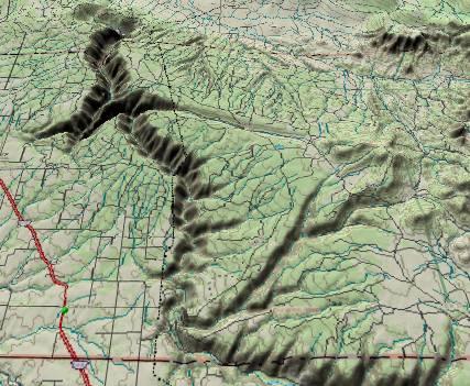 First, the Dolores River
downstream from McPhee Reservoir travels north-northwestward,
diagonally up and over an anticline carving a 2,000-foot deep
canyon in the process. (Right) Derivation of this path is not
based on current topography; hence, it must be old.
First, the Dolores River
downstream from McPhee Reservoir travels north-northwestward,
diagonally up and over an anticline carving a 2,000-foot deep
canyon in the process. (Right) Derivation of this path is not
based on current topography; hence, it must be old.
The Mancos River continues southward out of the valley cutting a 1,700-foot deep canyon through mesas that top out more than 8,000 feet above sea level. A much easier potential path exists. It could continue west (staying under 7,000 feet) to Cortez where it could follow either McElmo Creek or Navajo Wash. There are two other canyons just east of Mancos Canyon that have only local drainage, but at some time in the past, these other canyons had to be part of a tributary system to the Mancos River. Hence, the Mancos drainage system must be old.
McElmo Creek drains westward out of the valley in another canyon that is 1,600 feet below Goodman Point two miles to the north and 4,400 feet below Ute Mountain (less than 10 miles to the south). If it were to establish this course today, it would have to travel stratigraphically uphill. Hence, McElmo Creek must be old.
The easiest topographical route out of the Mancos Valley today (and lowest except for the canyon recently dug by McElmo Creek) is a broad valley extending south-southwestward from the town of Cortez toward the Four Corners. However, the only drainage it contains is Navajo Wash (usually dry).
The geologic history of a simple valley is relatively easy to understand, but knowing what happened does not add much to ancestral knowledge. A complex valley is more difficult to understand, but once the sequence is unraveled, it reveals a great deal about the past.
The first task is to sort the ancestry of each of the exiting rivers into chronological order. (We will use youngest to oldest.) The exit to the south-southwest (Navajo Wash) has no problem with the present topographical tilt, and there are no mesas or other barriers that the dry wash has to cut through. A broad valley exists in this direction that never exceeds 6,000 feet above sea level. In fact, McElmo Creek may have used this exit route in the past. The major hint here is the 6,000-foot maximum elevation.
The silt backup system that developed to the east of the rising Wasatch 5.4 million years ago covered everything up to at least 6,300 feet elevation. Hence, if McElmo Creek had used this exit route further back in the past, the silt backup buried this old route. Then, by the time ordinary erosion took over again, McElmo Creek had found its present route (see below). (If we go further back in time, the area that is now Navajo Wash was probably where the easily eroded Mancos Shale was exposed at the surface between the Sleeping Ute Mountain intrusions/uplift and Mesa Verde. Subsequently, Navajo Wash was eroded down to the 6,000-foot level by ordinary desert cloudbursts washing away the shale.)
McElmo Creek currently exits the valley due westward between Goodman Point Mesa (McElmo Dome) and Ute Mountain. Since it uses this route instead of the currently easier Navajo Wash route, the due west route must have been easier at some point in the past. Streams and canyons that feed into McElmo Canyon from the north provide clues. These streams (mostly dry arroyos) start north of the highest portions of McElmo Dome and cut southward through rising strata to get to McElmo Creek. When these streams developed, they had to be going downhill. These tributary streams look very young. Hence, the uplift that formed McElmo Dome must be even younger.
Of particular interest is Trail Canyon, which feeds southward into McElmo Creek some 7 miles west of Cortez. Trail Creek turns west the last two miles before it joins McElmo Creek. It is also entrenched over 600 feet deep in its own canyon at this point. Thus, the pattern of turning west to join McElmo Creek was imprinted while Trail Creek was still on the Dakota surface. This tells us that McElmo Creek also flowed westward on the same surface. This surface is uphill now, but it had to be downhill when the streams established their courses.
Finally, we note that the eastern portion of McElmo Creek near Cortez is below the 6,300-foot level of the Wasatch backup. This completes the clues of McElmo Creek’s current path and Navajo Wash. Prior to 5.4 million years ago, McElmo Creek’s path is uncertain but it probably traveled south-southwest down Navajo Wash’s present course. When the Wasatch backup reached Cortez, both routes were covered with silt. McElmo Dome was still hundreds of feet lower then it is today.
After the Colorado River overflowed across the Kaibab Plateau, canyon cutting worked its way back upstream. The current path of McElmo Creek is shorter than the old Navajo Wash route. Thus, McElmo Creek turned straight west. After this route was established, McElmo Dome (Goodman Point Mesa) rose to its present height. McElmo Creek used the standard “stationary in-place band saw” routine to cut the canyon. Meanwhile, Navajo Wash has also eroded rapidly. Desert thunderstorms have washed away the old backup silt, and have continued to cut down almost as rapidly into the easily eroded Mancos Shale that is underneath.
Of the two remaining drainage systems (The Mancos and Dolores Rivers), only the Mancos River system follows the current stratigraphic tilt. Hence, the Mancos River system is next in our sorted-by-age list. In the picture below, Mancos, Weber, and East Canyons join to form the main Mancos Canyon. (All near the left edge.)
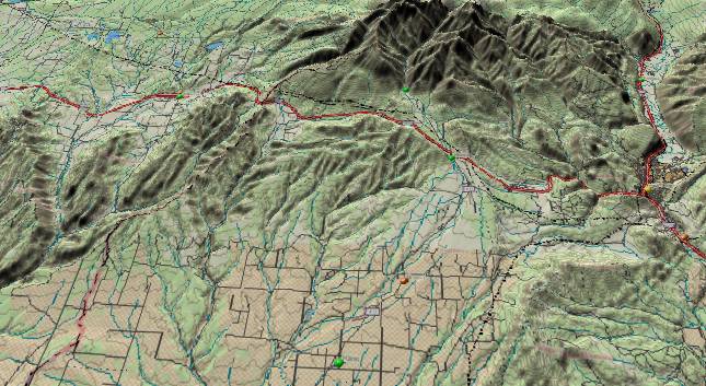
The Mancos River is a product of its three upper branches (East, Middle, and West Mancos Rivers), Chicken Creek, and the East and West Forks of Mud Creek. All the branches join before the river plows into Mancos Canyon on the south side of the valley (between Mesa Verde National Park and Weber Mountain). Further east, Weber and East Canyons also cut through the eastern extension of these mesas and join the Mancos further downstream. This tributary system had to originate before the canyons were cut. Originally, the six tributaries funneled into the three canyons (Which components went where is unknown except for their east to west order.)
The surface rock north of the mesas is the easily eroded Mancos Shale. After the initial three-canyon pattern was established, erosion of the shale lowered the terrain north of the mesas. This allowed the streams to join before plunging into Mancos Canyon. This left the other two canyons high and dry
On the geologic time scale this drainage probably originated in late Oligocene / early Miocene time. There was a regional uplift throughout much of southwestern Colorado starting in the Oligocene and continuing into the Miocene. Since there was greater uplift to the north and lesser to the south, the tilt of the old drainage that previously was down to the north, was reversed to become north to south across the mesas. This same pattern extended westward across Mesa Verde National Park. (Drainage in the western part of the park is more toward the south-southeast due to the Sleeping Ute uplift/intrusions.) Once the drainage got far enough south to get around the south side of Sleeping Ute Mountain, the Mancos River turned west. Further west it joined the San Juan River. (See the following section on the San Juan River as it too was diverted out of the Mancos Valley by the same uplift).
This ancestral path on the mesa surface has actually left a gravel deposit on the rim of Mancos Canyon at Soda Point just south of Mesa Verde National Park. Gravel deposits are difficult to date, but we can bracket the age of this one based on external circumstances. The deposit has to be old enough to predate canyon cutting. The primary factor is its 6,600-foot elevation. This puts it exactly where the Wasatch backup system should be considering it is 260 miles east-southeast of the old 6,300-foot bottleneck at Emigrant Pass. The gravel was deposited sometime between the advanced stages of this backup (estimated at 6 million years ago), and before canyon cutting worked its way back upstream (estimated at 5 million years ago).
The fourth river system that exits the Mancos Valley is the Dolores River. The Dolores pays no attention to current contours. Thus, for its origin we must go back in time until we find a period when the natural downhill direction was toward the north.
 In the Eocene, Lake Uinta
(probably a series of lakes over both time and horizontal
distances) existed in northeastern Utah and northwestern
Colorado. Lake Uinta (and the Uinta Basin) was the destination
for the ancestor of the Dolores River.
In the Eocene, Lake Uinta
(probably a series of lakes over both time and horizontal
distances) existed in northeastern Utah and northwestern
Colorado. Lake Uinta (and the Uinta Basin) was the destination
for the ancestor of the Dolores River.
During the early Tertiary, a large volume of surface rock was stripped from most of Arizona and the western slope of the newly risen Rockies. This material was carried northward and deposited in the Wasatch Formation. The Wasatch extends across large sections of northeastern Utah and northwestern Colorado. In addition, large volumes of sediments were carried still further northeastward into Wyoming where the Laramie Range was essentially buried. Thus, surface flow was from the south toward the north and northeast.
In the early Tertiary, the Mancos Valley (including the current flats that extend further toward the northwest) was bounded by Utah’s Monument Uplift to the west and the San Juan Mountains to the east. Any river that entered this region from the south would be funneled due north between these highlands.
Further north, the current Tavaputs Plateau in eastern Utah was part of the Uinta Basin during the Eocene. The Green River cuts through this plateau today to form Desolation Canyon. The sides of Desolation Canyon reveal a 4,000-foot thick sequence of sediments that were rapidly deposited in the Eocene (source: diagram in Belknap’s Desolation River Guide). The sediments in the southern portion of the basin are mostly sandstone while the northern side has more shale. Hence, these sediments came from the south. Today’s Dolores River joins the Colorado River less than 50 miles southeast of the center of the Tavaputs.
The ancestral San Juan River was born in the Eocene when drainage out of the San Juan basin shifted to flow northward. There was probably a minor stream flowing northward where the Dolores is today before this, but real volume didn’t develop until the newly developed San Juan River used this route to get to the Uinta Basin. The ancestral Chaco River joined the ancestral San Juan at Slick Rock, Colorado. The combined San Juan continued north to deposit the Tavaputs sediments. When (renewed) uplift occurred from the Abajo Mountains eastward to the La Platas toward the end of the Oligocene, this ancestral river system was forced to relocate southward leaving only the Dolores River (a former tributary) in sole possession of the riverbed.
All of the above leads to the following sequence. During the Eocene both the ancestral San Juan River and the Chaco River formed when drainage from the San Juan Basin changed from exiting eastward to exiting northward. The ancestral San Juan River entered the Mancos Valley area from the east-southeast near present-day Mancos Hill (U.S. highway 160). The ancestral San Juan River occupied the current path of the Dolores River from McPhee Reservoir northward.
The ancient Chaco River flowed northward from northwest New Mexico probably staying slightly west of Sleeping Ute Mountain and continued northward to where it joined the ancestral San Juan at Slick Rock, Colorado. (An alternate course going around the east side of Sleeping Ute Mountain is also possible) Another small tributary from the west joined the ancestral Chaco at the present junction of Bishop and Summit Canyons. These paths remained in place while the ancient surface layer was worn down to the Dakota Sandstone.
(Note: USGS topographic maps show a series of over two dozen “gravel pits” scattered across the approximate path of the ancient Chaco. These “gravel pits” do not contain rounded cobbles, and their only material is recently fractured and weathered chunks of the underlying Dakota Sandstone. If you see the “gravel pits” on topo maps, you can safely ignore them.)
Toward mid Oligocene time, the junction point of the two rivers may have relocated a little further south to just northeast of the current town of Dove Creek, Colorado. This might have been associated with erosion or downdropping along faults associated with the Glade Creek Graben.
 About late Oligocene
time there was a general uplift of the southwest Colorado area
as well as larger local uplifts of the Abajo and La Plata
Mountains. The area covered by the uplift was much broader
than either the ancestral San Juan River or the Chaco River
could cut through, and the San Juan relocated southward into
New Mexico. From there it found an easier route westward
between the Monument and Defiance Plateaus. The Chaco River
abandoned the Colorado portion of its route and joined the
relocated San Juan in northwest New Mexico. About the same
time, the Chuska Mountains also rose in New Mexico. If the
ancestral Chaco River had been a little west of where it is
now, this uplift forced it eastward to its present location.
About late Oligocene
time there was a general uplift of the southwest Colorado area
as well as larger local uplifts of the Abajo and La Plata
Mountains. The area covered by the uplift was much broader
than either the ancestral San Juan River or the Chaco River
could cut through, and the San Juan relocated southward into
New Mexico. From there it found an easier route westward
between the Monument and Defiance Plateaus. The Chaco River
abandoned the Colorado portion of its route and joined the
relocated San Juan in northwest New Mexico. About the same
time, the Chuska Mountains also rose in New Mexico. If the
ancestral Chaco River had been a little west of where it is
now, this uplift forced it eastward to its present location.
The Dolores River, which was formerly just a tributary to the ancestral San Juan River, has its headwaters in high ground that was lifted still higher. It was thus able to continue in the ancestral path where it remains today. The path of the Chaco across southwestern Colorado was left high and dry. Small local streams continued to use the ancestral path near the Dolores River. When the Dolores River anticline rose and the Dolores cut down through it, these local streams were also able to cut down. Thus, we have the Summit/Bishop Canyon complex northwest of Egnar, Colorado as well as Big and Secret Canyons northeast of Dove Creek.
First, the Dolores River
downstream from McPhee Reservoir travels north-northwestward,
diagonally up and over an anticline carving a 2,000-foot deep
canyon in the process. (Right) Derivation of this path is not
based on current topography; hence, it must be old.The Mancos River continues southward out of the valley cutting a 1,700-foot deep canyon through mesas that top out more than 8,000 feet above sea level. A much easier potential path exists. It could continue west (staying under 7,000 feet) to Cortez where it could follow either McElmo Creek or Navajo Wash. There are two other canyons just east of Mancos Canyon that have only local drainage, but at some time in the past, these other canyons had to be part of a tributary system to the Mancos River. Hence, the Mancos drainage system must be old.
McElmo Creek drains westward out of the valley in another canyon that is 1,600 feet below Goodman Point two miles to the north and 4,400 feet below Ute Mountain (less than 10 miles to the south). If it were to establish this course today, it would have to travel stratigraphically uphill. Hence, McElmo Creek must be old.
The easiest topographical route out of the Mancos Valley today (and lowest except for the canyon recently dug by McElmo Creek) is a broad valley extending south-southwestward from the town of Cortez toward the Four Corners. However, the only drainage it contains is Navajo Wash (usually dry).
The geologic history of a simple valley is relatively easy to understand, but knowing what happened does not add much to ancestral knowledge. A complex valley is more difficult to understand, but once the sequence is unraveled, it reveals a great deal about the past.
The first task is to sort the ancestry of each of the exiting rivers into chronological order. (We will use youngest to oldest.) The exit to the south-southwest (Navajo Wash) has no problem with the present topographical tilt, and there are no mesas or other barriers that the dry wash has to cut through. A broad valley exists in this direction that never exceeds 6,000 feet above sea level. In fact, McElmo Creek may have used this exit route in the past. The major hint here is the 6,000-foot maximum elevation.
The silt backup system that developed to the east of the rising Wasatch 5.4 million years ago covered everything up to at least 6,300 feet elevation. Hence, if McElmo Creek had used this exit route further back in the past, the silt backup buried this old route. Then, by the time ordinary erosion took over again, McElmo Creek had found its present route (see below). (If we go further back in time, the area that is now Navajo Wash was probably where the easily eroded Mancos Shale was exposed at the surface between the Sleeping Ute Mountain intrusions/uplift and Mesa Verde. Subsequently, Navajo Wash was eroded down to the 6,000-foot level by ordinary desert cloudbursts washing away the shale.)
McElmo Creek currently exits the valley due westward between Goodman Point Mesa (McElmo Dome) and Ute Mountain. Since it uses this route instead of the currently easier Navajo Wash route, the due west route must have been easier at some point in the past. Streams and canyons that feed into McElmo Canyon from the north provide clues. These streams (mostly dry arroyos) start north of the highest portions of McElmo Dome and cut southward through rising strata to get to McElmo Creek. When these streams developed, they had to be going downhill. These tributary streams look very young. Hence, the uplift that formed McElmo Dome must be even younger.
Of particular interest is Trail Canyon, which feeds southward into McElmo Creek some 7 miles west of Cortez. Trail Creek turns west the last two miles before it joins McElmo Creek. It is also entrenched over 600 feet deep in its own canyon at this point. Thus, the pattern of turning west to join McElmo Creek was imprinted while Trail Creek was still on the Dakota surface. This tells us that McElmo Creek also flowed westward on the same surface. This surface is uphill now, but it had to be downhill when the streams established their courses.
Finally, we note that the eastern portion of McElmo Creek near Cortez is below the 6,300-foot level of the Wasatch backup. This completes the clues of McElmo Creek’s current path and Navajo Wash. Prior to 5.4 million years ago, McElmo Creek’s path is uncertain but it probably traveled south-southwest down Navajo Wash’s present course. When the Wasatch backup reached Cortez, both routes were covered with silt. McElmo Dome was still hundreds of feet lower then it is today.
After the Colorado River overflowed across the Kaibab Plateau, canyon cutting worked its way back upstream. The current path of McElmo Creek is shorter than the old Navajo Wash route. Thus, McElmo Creek turned straight west. After this route was established, McElmo Dome (Goodman Point Mesa) rose to its present height. McElmo Creek used the standard “stationary in-place band saw” routine to cut the canyon. Meanwhile, Navajo Wash has also eroded rapidly. Desert thunderstorms have washed away the old backup silt, and have continued to cut down almost as rapidly into the easily eroded Mancos Shale that is underneath.
Of the two remaining drainage systems (The Mancos and Dolores Rivers), only the Mancos River system follows the current stratigraphic tilt. Hence, the Mancos River system is next in our sorted-by-age list. In the picture below, Mancos, Weber, and East Canyons join to form the main Mancos Canyon. (All near the left edge.)
The Mancos River is a product of its three upper branches (East, Middle, and West Mancos Rivers), Chicken Creek, and the East and West Forks of Mud Creek. All the branches join before the river plows into Mancos Canyon on the south side of the valley (between Mesa Verde National Park and Weber Mountain). Further east, Weber and East Canyons also cut through the eastern extension of these mesas and join the Mancos further downstream. This tributary system had to originate before the canyons were cut. Originally, the six tributaries funneled into the three canyons (Which components went where is unknown except for their east to west order.)
The surface rock north of the mesas is the easily eroded Mancos Shale. After the initial three-canyon pattern was established, erosion of the shale lowered the terrain north of the mesas. This allowed the streams to join before plunging into Mancos Canyon. This left the other two canyons high and dry
On the geologic time scale this drainage probably originated in late Oligocene / early Miocene time. There was a regional uplift throughout much of southwestern Colorado starting in the Oligocene and continuing into the Miocene. Since there was greater uplift to the north and lesser to the south, the tilt of the old drainage that previously was down to the north, was reversed to become north to south across the mesas. This same pattern extended westward across Mesa Verde National Park. (Drainage in the western part of the park is more toward the south-southeast due to the Sleeping Ute uplift/intrusions.) Once the drainage got far enough south to get around the south side of Sleeping Ute Mountain, the Mancos River turned west. Further west it joined the San Juan River. (See the following section on the San Juan River as it too was diverted out of the Mancos Valley by the same uplift).
This ancestral path on the mesa surface has actually left a gravel deposit on the rim of Mancos Canyon at Soda Point just south of Mesa Verde National Park. Gravel deposits are difficult to date, but we can bracket the age of this one based on external circumstances. The deposit has to be old enough to predate canyon cutting. The primary factor is its 6,600-foot elevation. This puts it exactly where the Wasatch backup system should be considering it is 260 miles east-southeast of the old 6,300-foot bottleneck at Emigrant Pass. The gravel was deposited sometime between the advanced stages of this backup (estimated at 6 million years ago), and before canyon cutting worked its way back upstream (estimated at 5 million years ago).
The fourth river system that exits the Mancos Valley is the Dolores River. The Dolores pays no attention to current contours. Thus, for its origin we must go back in time until we find a period when the natural downhill direction was toward the north.
In the Eocene, Lake Uinta
(probably a series of lakes over both time and horizontal
distances) existed in northeastern Utah and northwestern
Colorado. Lake Uinta (and the Uinta Basin) was the destination
for the ancestor of the Dolores River.During the early Tertiary, a large volume of surface rock was stripped from most of Arizona and the western slope of the newly risen Rockies. This material was carried northward and deposited in the Wasatch Formation. The Wasatch extends across large sections of northeastern Utah and northwestern Colorado. In addition, large volumes of sediments were carried still further northeastward into Wyoming where the Laramie Range was essentially buried. Thus, surface flow was from the south toward the north and northeast.
In the early Tertiary, the Mancos Valley (including the current flats that extend further toward the northwest) was bounded by Utah’s Monument Uplift to the west and the San Juan Mountains to the east. Any river that entered this region from the south would be funneled due north between these highlands.
Further north, the current Tavaputs Plateau in eastern Utah was part of the Uinta Basin during the Eocene. The Green River cuts through this plateau today to form Desolation Canyon. The sides of Desolation Canyon reveal a 4,000-foot thick sequence of sediments that were rapidly deposited in the Eocene (source: diagram in Belknap’s Desolation River Guide). The sediments in the southern portion of the basin are mostly sandstone while the northern side has more shale. Hence, these sediments came from the south. Today’s Dolores River joins the Colorado River less than 50 miles southeast of the center of the Tavaputs.
The ancestral San Juan River was born in the Eocene when drainage out of the San Juan basin shifted to flow northward. There was probably a minor stream flowing northward where the Dolores is today before this, but real volume didn’t develop until the newly developed San Juan River used this route to get to the Uinta Basin. The ancestral Chaco River joined the ancestral San Juan at Slick Rock, Colorado. The combined San Juan continued north to deposit the Tavaputs sediments. When (renewed) uplift occurred from the Abajo Mountains eastward to the La Platas toward the end of the Oligocene, this ancestral river system was forced to relocate southward leaving only the Dolores River (a former tributary) in sole possession of the riverbed.
All of the above leads to the following sequence. During the Eocene both the ancestral San Juan River and the Chaco River formed when drainage from the San Juan Basin changed from exiting eastward to exiting northward. The ancestral San Juan River entered the Mancos Valley area from the east-southeast near present-day Mancos Hill (U.S. highway 160). The ancestral San Juan River occupied the current path of the Dolores River from McPhee Reservoir northward.
The ancient Chaco River flowed northward from northwest New Mexico probably staying slightly west of Sleeping Ute Mountain and continued northward to where it joined the ancestral San Juan at Slick Rock, Colorado. (An alternate course going around the east side of Sleeping Ute Mountain is also possible) Another small tributary from the west joined the ancestral Chaco at the present junction of Bishop and Summit Canyons. These paths remained in place while the ancient surface layer was worn down to the Dakota Sandstone.
(Note: USGS topographic maps show a series of over two dozen “gravel pits” scattered across the approximate path of the ancient Chaco. These “gravel pits” do not contain rounded cobbles, and their only material is recently fractured and weathered chunks of the underlying Dakota Sandstone. If you see the “gravel pits” on topo maps, you can safely ignore them.)
Toward mid Oligocene time, the junction point of the two rivers may have relocated a little further south to just northeast of the current town of Dove Creek, Colorado. This might have been associated with erosion or downdropping along faults associated with the Glade Creek Graben.
About late Oligocene
time there was a general uplift of the southwest Colorado area
as well as larger local uplifts of the Abajo and La Plata
Mountains. The area covered by the uplift was much broader
than either the ancestral San Juan River or the Chaco River
could cut through, and the San Juan relocated southward into
New Mexico. From there it found an easier route westward
between the Monument and Defiance Plateaus. The Chaco River
abandoned the Colorado portion of its route and joined the
relocated San Juan in northwest New Mexico. About the same
time, the Chuska Mountains also rose in New Mexico. If the
ancestral Chaco River had been a little west of where it is
now, this uplift forced it eastward to its present location.The Dolores River, which was formerly just a tributary to the ancestral San Juan River, has its headwaters in high ground that was lifted still higher. It was thus able to continue in the ancestral path where it remains today. The path of the Chaco across southwestern Colorado was left high and dry. Small local streams continued to use the ancestral path near the Dolores River. When the Dolores River anticline rose and the Dolores cut down through it, these local streams were also able to cut down. Thus, we have the Summit/Bishop Canyon complex northwest of Egnar, Colorado as well as Big and Secret Canyons northeast of Dove Creek.
Return to Dolores River - Dolores to Gateway, Colorado (Part 4)
Continue to Bridge Timber Mountain and the ancestral San Juan River (Part 6)
Return to the Main Appendix Page for the Evolution of the Colorado River
Web page generated via Sea Monkey's Composer HTML editor
within a Linux Cinnamon Mint 18 operating system.
(Goodbye Microsoft)