
Durango Bill's
Paleogeography (Historical Geology) Research
La Plata Mountains and Bridge Timber Mountain, Colorado
A chronology for the gravel deposits on Bridge Timber Mountain
View to the
north with contour intervals of 100 feet. The La Plata
Mountains are in the upper right portion of the picture.
Durango, Colorado is near the right edge. Near the left edge
Mancos, Weber, and East Canyons merge to form the main Mancos
River, and a piece of Mesa Verde National Park is visible on
the left edge.
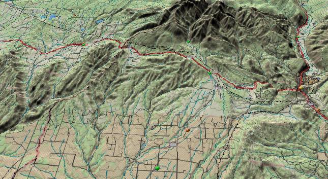
The source of the La
Plata River is at the northern end of the La Plata Mountains
and then it splits the range lengthwise as it flows southward.
Bridge Timber Mountain shows up as a faint fuzzy label just
above the lower right edge. Bridge Timber Mountain is more
than 1,000 feet higher than any other point of land within 25
miles both to the east and west of it including the large flat
area shown in the picture. Its summit also has river gravels
including boulders up to 6 feet long. How and when did they
get there?
This area to the west and southwest of Durango has one of the most complex histories of any area in the Rockies. There was an initial uplift of the La Plata Mountains due to igneous intrusions some 65 to 70 million years ago. When the San Juan Basin (to the south and southeast off the lower edge of the picture) rebounded in the Eocene, the ancestral San Juan River was born and flowed from lower right to upper left across this area. (See the Dolores page) Then, regional uplift about the end of the Oligocene forced the San Juan River south into New Mexico. The uplift also changed the tilt across most of the view area from down-to-the-north to down-to-the-south. This set up the drainage for the Mancos River system.
The sequence that we propose in this model attributes the Bridge Timber gravel deposits to remnants of the San Juan/Animas/La Plata River system that prevailed about the time the San Juan abandoned this ancient route some 25 to 30 million years ago.
The currently published model for these deposits credits them to an outwash fan by the La Plata River as it washed down from the La Plata Mountains. The age of the deposits via this alternate model would be within the last 5 million years.
In either case there was once a river that crossed the top of Bridge Timber Mountain. Then all the surrounding terrain was worn down to what we see now. A key question is how long would it take to erode over 1,000 feet from the terrain on all sides of the mountain, and then leave the flat surface stretching over 20 miles to the west (to the left of the mountain)? We leave it to future research to settle the issue.
Also please see “Bridge Timber Mountain and the Ancestral San Juan River”
http://www.durangobill.com/PaleoAppendPart6.html
Return to the Image Index Page
Web page generated via Sea Monkey's Composer HTML editor
within a Linux Cinnamon Mint 18 operating system.
(Goodbye Microsoft)