
Durango Bill’s
Grand Canyon 3-D Tour
About 1.25 miles
North-Northeast of Pearce Ferry
Near River Mile 280
Superimposition Rapid
alternately
Pearce Ferry Rapid
Near River Mile 280
Superimposition Rapid
alternately
Pearce Ferry Rapid
(Also please see
Lower
Superimposition
Rapid)
A chronology of transitions from:
1) Lake Mead
2) To a new superimposed path for the Colorado River
3) Which became a “riffle” near the old Pearce Ferry take-out.
4) This “riffle” became a moderately severe rapid in late 2007.
5) The combination of silt deposited by the river along with highly variable water levels in Lake Mead will continue to produce rapid changes in years to come.
Satellite views
1985, 2010, 2014, and 2017
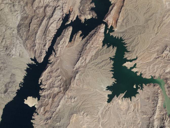
The photographs shown above and below were posted on NASA’s Earth Observatory page on Sept. 22, 2010. http://earthobservatory.nasa.gov/IOTD/view.php?id=45945
Both photographs show:
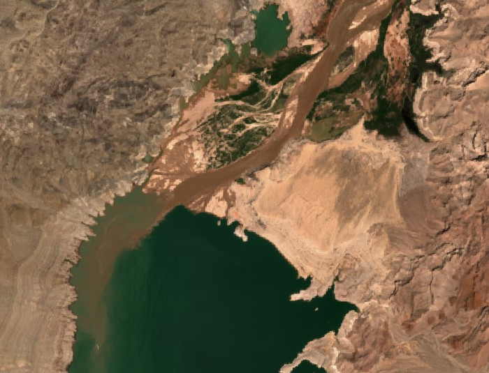
1) The extreme western end of the Grand Canyon (lower right edge)
2) Pearce Bay (To the right and slightly below the center of the photos)
3) Wheeler Ridge (Above and to the right of the center of the photos)
4) Iceberg Canyon (Upper left quadrant)
5) Gregg Basin and Sandy Point (Lower left quadrant)
However, the top photo was taken Aug. 22, 1985 while the bottom photo was taken Aug. 11, 2010.
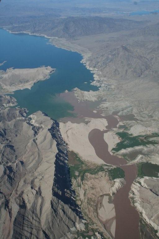
In the 25 year interval from 1985 to 2010, the Colorado River deposited many hundreds of millions of tons of silt into the former upper end of Lake Mead. Water levels in Lake Mead have been dropping since 1998. The narration below describes the result.
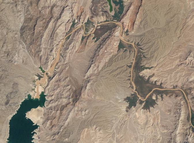
The picture above is via NASA’s Earth Observatory and shows the status of the lower end of the river as of July 21, 2014. Lake Mead is currently at its lowest level since it was being filled in the 1930s. The Colorado River’s delta has now reached the north shore of Sandy Point.
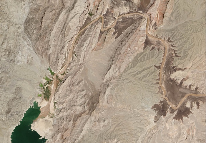
The picture above is a Google Earth view as of June 2017. The Colorado River's delta has filled in most of the area to the north of Sandy Point. The delta will inexorably continue to build southward out into Lake Mead; but once past the tip of Sandy Point, progress will be slower since the lake is much wider.
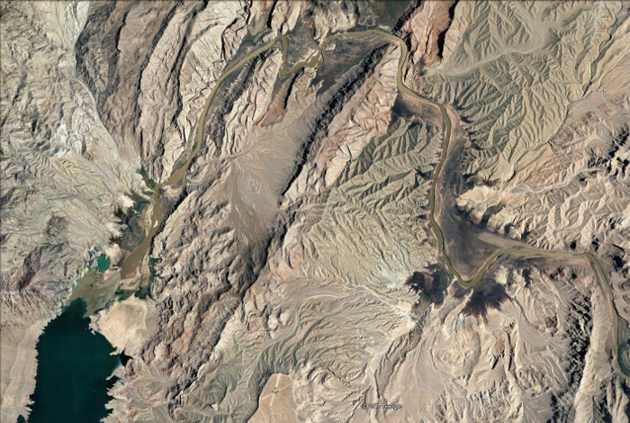
The picture above shows Sandy Point and the upper end of Lake Mead as of May 2021. The Colorado River's growing delta has filled in the lake to the north and west of Sandy Point. The delta will inevitably continue to push out into Lake Mead, but progress from here on will be much slower. An estimated date for the cutoff of the South Cove boat ramp will be about the year 2040. However, the water level in Lake Mead is expected to drop below the end of the boat ramp by mid 2022.
Construction of Hoover Dam (Boulder Dam) began in 1931 and was completed in 1935 as part of a project to “reclaim the desert for productive human usage”. (Hence the name “Bureau of Reclamation”.) By early 1941, the Colorado River had filled the reservoir to capacity to form Lake Mead.
The historic photograph below was taken July 12, 1950, and shows what the upper end of Lake Mead looked like before large amounts of sediment had accumulated. (Estimated water level is 1176 feet.) This and other historic photographs of the area can be found at the USGS Earth Explorer web site at http://earthexplorer.usgs.gov/ (For the photo below, use the map to zoom in (and click ) on what used to be the east end of Lake Mead, pick a date prior to 1955, click on “Data Sets”, expand “Aerial Imagery”, check “Aerial Photos Single Frames”, and click on “Results”.)
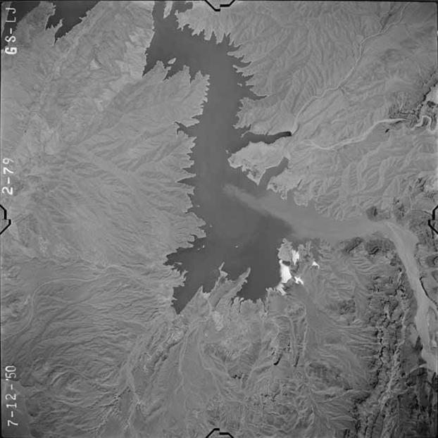
The silt-laden Colorado River exits from the Grand Canyon (lower right quadrant) into Lake Mead. Pearce Bay is in the lower left portion of the lake, and what will become the location for Superimposition Rapid is just to the right of the two points of land that stick out into the lake just to the north of Pearce Bay. If you look just to the right of the northernmost of the two points, you can see a small island. There is a submerged ridge that connects this island with the higher ground to the left, and after another 50+ years of changes to Lake Mead, the river will hang up on this old ridge to produce Superimposition Rapid.
Before Glen Canyon Dam was built, the silt load of the Colorado River (as measured near Phantom Ranch in the Grand Canyon) averaged 3 to 5 tons per second. (Different sources give different amounts) Before Hoover Dam was built, this sediment ended up in the Colorado River’s delta, but after it was built, it was all deposited in Lake Mead.
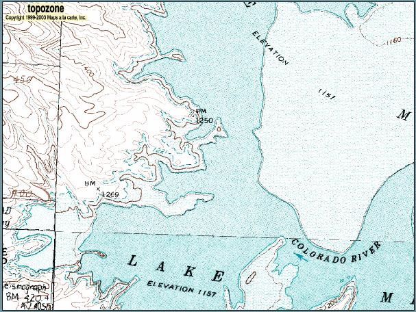
The topographic map above from http://www.topozone.com shows the old ridge that the river is now crossing. (The old ridge is the narrow peninsula that sticks out into the lake just below the BM 1250 label.) The lowest lake shoreline shows that the top of the old ridge was exposed above the 1157-foot level. (The estimate date for the low-lake contours is about mid 1972.) Also the 1160-foot contour line is shown on the ridge which increases the pre-erosion level of the old ridge to above the 1160-foot level.
The small island that could be seen in the previous 1950 photo shows up as the small hill (closed 1200-foot contour) at the end of the peninsula. The Pearce Ferry take-out is off the bottom edge of the map to the left of center.
An April 15, 1962 photograph at http://www6.nau.edu/library/scadb/imagedisplay.cfm?item_num=9383&type=Image
also shows this old ridge exposed above an estimated Lake Mead water level of 1157 feet. (View looks south with the peninsula just above the lower edge.)
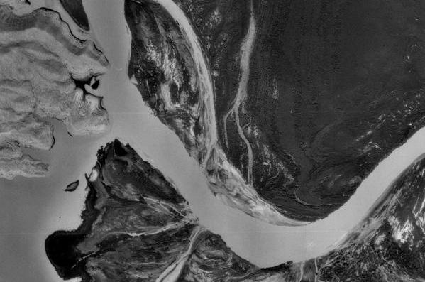
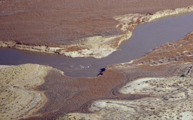
The picture above shows the location for the incipient rapid as it appeared in September 1992. (Estimated Lake Mead elevation is 1174 feet.) The upper end of Lake Mead has filled with silt. Pearce Bay is in the lower left hand corner. The two points of land in the upper left corner are the same as shown in the earlier pictures. What was an island in the first picture and the end of the peninsula in the topo map, is now the small triangular light area just to the right of the river. This area will be submerged again during the high water levels seen in the late 1990s (see graph below), but the final path of the river will be near what can be seen in this photograph.
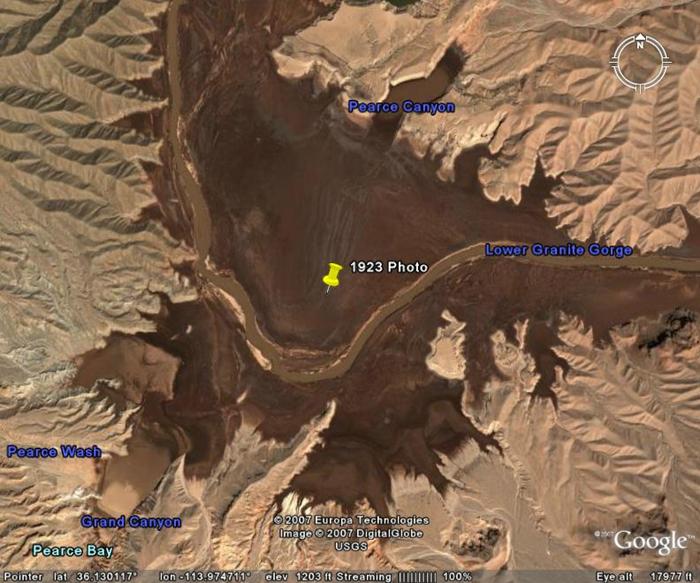
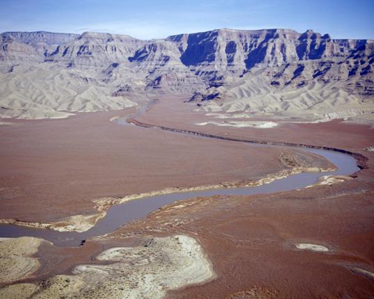
Vertical view of what used to be the northeast end of Lake Mead. (Estimated date for the photograph is April 8, 2004. Estimated Lake Mead elevation is 1140 feet.) The (historic) take-out at Pearce Ferry (at the lower end of Pearce Wash) is in the lower left quadrant - near River Mile 280 in the standard Grand Canyon river guide books. “Superimposition Rapid” has subsequently formed where the two ridges closely approach the river - midway between the pin and the left edge. The pin marks the estimated location of the 1923 photograph shown at the bottom of this page.
Before Hoover (Boulder) Dam was built, the Colorado River exited from the Grand Canyon (off the right edge of the picture) and flowed left and up across what are now the mudflats in the picture, to exit off the top edge (left of center). After Hoover Dam was completed, the reservoir backed up to cover the dark brown area in the picture with water. What was part of Lake Mead as seen in the first photograph has now been transformed into the dark brown mud flats.
Over a period of several decades, silt brought down by the Colorado River filled in the old river channel and spread out to cover an area more than a mile wide to form a broad silt flat. The bottom of the old river channel is some 300 feet down under the silt. (A graph at http://www.durangobill.com/GCriverProfile.html shows the river elevations for both before and after Hoover (Boulder) Dam.)
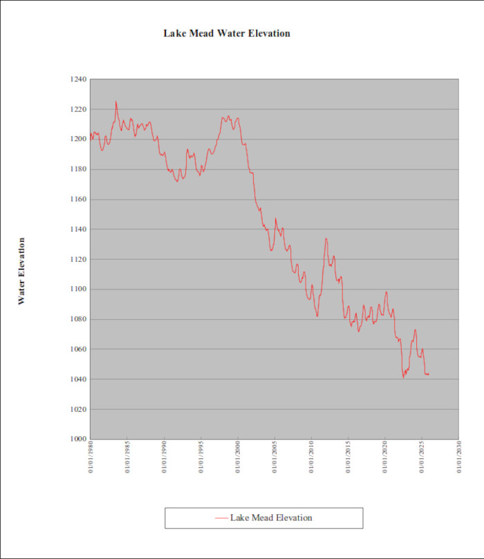
The graph above shows the water level in Lake Mead starting with 1980. The plotted levels into 2024 are forecasts via the U. S. Bureau of Reclamation as of the Nov., 2022 USBR report http://www.usbr.gov/lc/riverops.html
Historical water levels can be seen at http://www.usbr.gov/lc/region/g4000/hourly/mead-elv.html
The water level in Lake Mead reached its maximum elevation in 1983. When the lake level subsequently receded from this maximum elevation, the river had no guide as to the location of the old channel, and established a new path across the silt flats, approximately in its current position. Most of this new path area was periodically exposed and resubmerged over the next 20 years, but the drought that has set in during the early 2000s has severely lowered Lake Mead. As the water level lowered, the river became entrenched in its new path.
Please see “Transition to a more arid Southwest” (and related technical paper links) at http://www.ldeo.columbia.edu/res/div/ocp/drought/science.shtml for the reasons why drought conditions are developing. (And be sure to give the authors an A+ for recognizing the current problem in advance.)
The geological sequence of burying an old landscape under silt/sediment and then establishing a new river drainage system across the top of these sediments is a process called superimposition. In a normal geologic time frame, this requires many millions of years. Here, at the upper end of Lake Mead, a man-made version of the process has taken only a few decades.
In a normal geologic sequence, a new superimposed river system might end up over the top of an ancient mountain range. If subsequent erosion removes the softer sediments, it’s quite possible the superimposed river might remain stuck in its path and erode its way down through the old mountain range to form a canyon.
Here, in the remnant of the upper end of Lake Mead, the silt deposits buried an old ridge. When the Colorado River established its new course after the 1983 maximum elevation of Lake Mead, the river happened to end up over the top of an old ridge. When the water level in Lake Mead subsequently dropped, sediments on the downstream side of the ridge eroded away. However, the ridge resisted erosion. The river thus formed a rapid where it dropped from the relatively higher elevation of the ridge to the relatively lower elevation downstream. It seems appropriate to name the rapid “Superimposition Rapid”. (Alternately, if the rapid were named for its geographical location, it might be named Pearce Ferry Rapid or Pierce Ferry Rapid.)
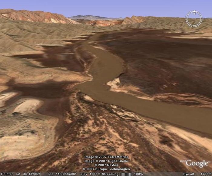
The picture above shows what the landscape at “Superimposition Rapid” looked like before Lake Mead dropped low enough for the rapid to form. The Colorado River is entrenched in a path that forces it to cross an old ridge. The area where the river crosses the ridge can also be seen in the first Google Earth picture - midway between the pin and the left edge. In both views the river enters from the right and then flows toward the top of the picture.
The Google Earth satellite picture (above) was probably taken on April 8, 2004 and covers approximately the same area as the Vishnu Temple Press photo below. With a little work you can find the exact spot where the Vishnu picture was taken. The white sand in the foreground of the Vishnu picture will match the lower right end of the white sand patches in the Google Earth picture. (On the left side of the river, above and slightly to the right of the center copyright labels.)
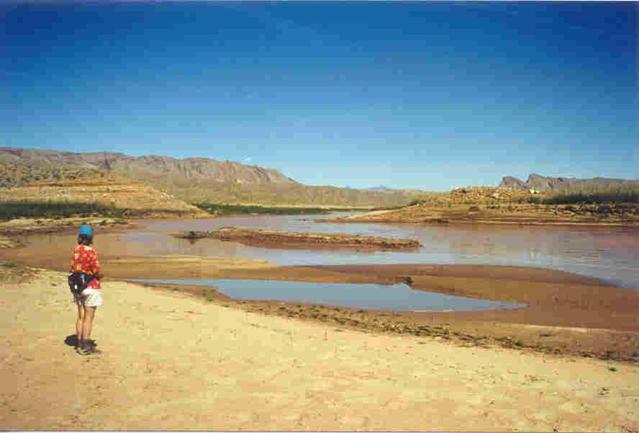
The photograph above is similar to the Google Earth picture and was taken on March 22, 2003. It was originally posted on the Vishnu Temple Press website (Good source for rafting guide books.), and while it is no longer posted there, you can see the original web page at: http://web.archive.org/web/20031208154023/www.vishnutemplepress.com/pearceferry.html
The photograph above was taken by Tom Martin at nearly the same location as the Vishnu Temple Press photograph - but in Feb. 2008. It is inserted here (a jump in the time sequence) to show what has happened in the 5 year period from 2003 to 2008. Notice how the river has dug down through the sediments. (For example, the ridge a couple of hundred yards downstream in the upper left is now part of the skyline as the photographic location is now 20 to 30 feet lower.)
As the elevation of Lake Mead dropped due to the drought, the Colorado River had an easy chance to erode the silt deposits that were deposited before the drought lowered the water level. The exception is the ridge. When Lake Mead dropped below the 1120-foot level in 2007, the river could erode the silt sediments downstream from the ridge, but the ridge acted as a dam and protected the sediments above the ridge. The ridge itself became the crest of the new rapid. (This is the upstream portion of the rapid which is a couple of hundred feet upstream from the large rock that subsequently emerged.)
The two pictures below are from an aerial U.S. Bureau of Reclamation photograph that can be seen at http://www.usbr.gov/lc/region/g5000/photolab/gallery_detail.cfm?PICIDTYPE=13209
This first picture looks east across the (historic) easternmost end of Lake Mead. In the distance, the Colorado River exits from the Grand Canyon, flows westward (toward the foreground) across the silt flats, and then turns north to flow off the left edge of the picture. The old Pearce Ferry takeout is well off the lower right edge while the location for the new rapid is in the lower left corner.
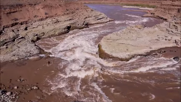
The picture above is an enlargement of the lower left corner of the previous picture. Both views show what the incipient rapid looked like on Feb. 2, 2006 - Lake Mead elevation about 1140 feet.
Standing waves from a submerged pour-over rock (part of the old ridge) can be seen.
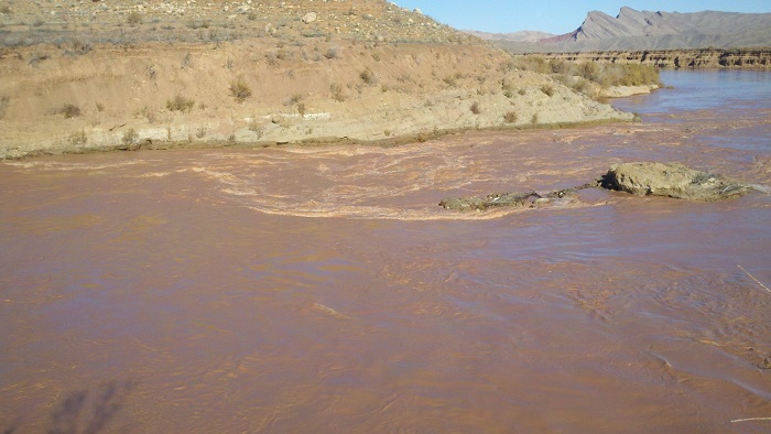
As of late July 2007, the surface elevation of Lake Mead had dropped about 29 feet from where it was in Feb 2006. The soft sediments that were deposited by the river over the last 6 decades can be easily eroded. This leaves two major possibilities. 1) If the rock in the old ridge can resist further erosion, then a severe rapid will form on the downstream (left) side of the old ridge. 2) The river just might be able to erode down through the old ridge. If it can erode downward, there will still be a rapid, but the drop-off will be less, and hence the rapid will be less severe.
 The photograph at the
right was taken by “bobkerry44” on Oct. 7, 2006 and is a copy of
the original which is posted in the photos section at the gcpba
Yahoo Group. The photograph was taken from near the right bank of
the river and looks northwestward across the river to the same
portion of the ridge that appears on the left side in the Vishnu
picture.
The photograph at the
right was taken by “bobkerry44” on Oct. 7, 2006 and is a copy of
the original which is posted in the photos section at the gcpba
Yahoo Group. The photograph was taken from near the right bank of
the river and looks northwestward across the river to the same
portion of the ridge that appears on the left side in the Vishnu
picture.The Vishnu picture was taken in March 2003 with the water level in Lake Mead at about 1154 feet. By Oct 7, 2006 the lake had dropped to about 1126 feet. The river had already taken advantage of this height difference to erode downward toward the old ridge. The pour-over rock that is in the center of the photograph is part of the top of the old ridge. As the lake continues to drop in the future, the river will become increasingly hung up on the old ridge and the rapid will gradually become more severe.
The following 3 pictures were taken from “North Point” (the left ridge in the Vishnu picture) and look southeast to south over the rapid. The sequence is a record of what was happening in the fall and winter of 2007/2008.
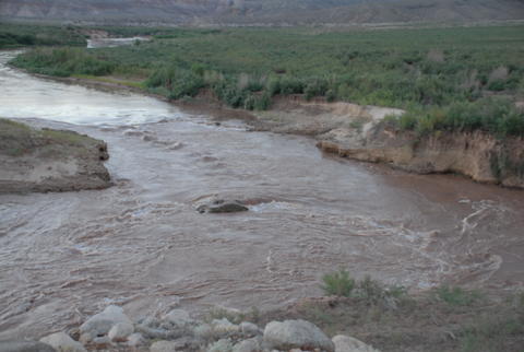
The first picture was taken on Sept. 1, 2007 by Duwain Whitis (“Guide to the Colorado River in the Grand Canyon” by Tom Martin and Duwain Whitis)
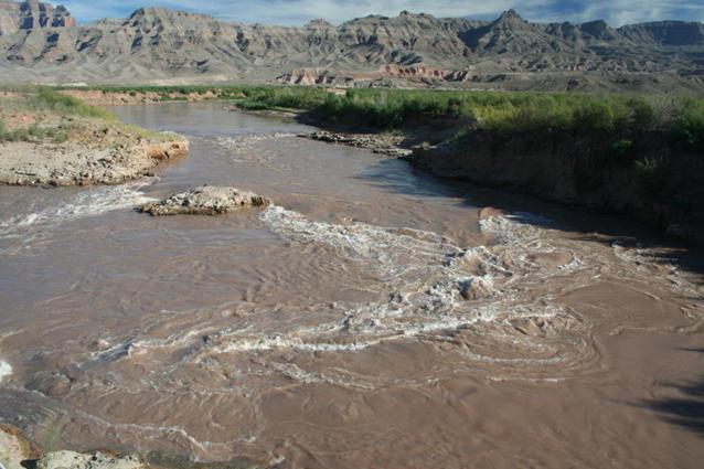
This next photograph was taken on Oct. 8, 2007 by Tom Martin (River Runners For Wilderness) and coauthor of the above river guide.
Finally, the third picture (below) was by Tom Martin in Feb. 2008.
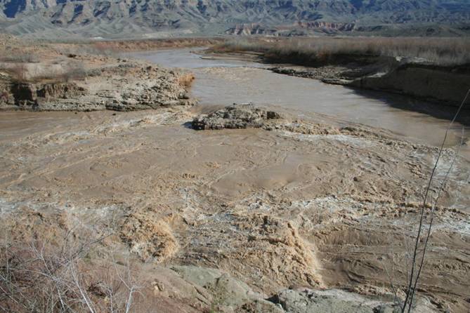
Two items of interest are of note. The most obvious is the large rock in the middle of the river. Also there is a smaller riffle about 200 feet upstream from the rock.
Update as of June 30, 2009
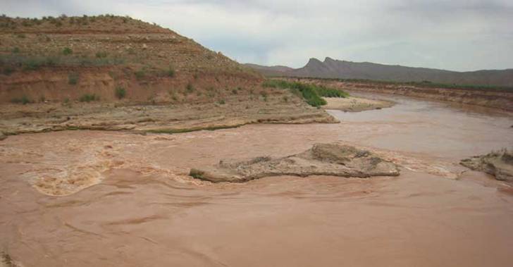
The photograph above was taken by David Witton and shows the status of the rapid as of June 1, 2009. The photo was taken from the left (west) bank of the river and looks slightly west of due north. The tilted strata in Wheeler Ridge can be seen in the distance.
The top of the ridge on the left side of the photo was the viewpoint for the previous pictures. This view looks downstream over the rapid. The lower part of the ridge reveals horizontal layers of loosely consolidated silt and gravel that were deposited some 5 to 15 million years ago. These rock layers are not cemented together as solidly as the much older rocks that are exposed in the Grand Canyon. Thus the river has been able to erode down through them fairly rapidly.
As the river erodes down through these more easily eroded layers, the original submerged rock (which apparently is a patch of conglomerate) has gone through the following stages.
1) The rock was initially submerged and just produced waves in the river.
2) The river began to carve out channels around the rock (mostly to the left/west). As the river carved the lower channels the rock emerged above the surface.
3) Further down-cutting by the river has allowed a ledge to be exposed to the left (west) of the rock. There is also another submerged rock that shows up near the left edge of the photo.
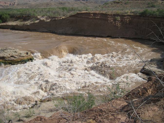
Update as of March 5, 2010
The picture above was taken by Tom Martin about March 2, 2010, and can be seen in the Gallery of pictures at the River Runners for Wilderness website. http://www.rrfw.org/gallery/
The view is taken from “North Point” bluff, and looks southeast across the rapid. The river continues to cut down several feet per year through poorly consolidated, 5 to 15 million year old rock. In the process, patches of somewhat harder conglomerate rock are becoming more exposed as the river erodes a deeper channel around them.
A ledge extending westward (from left to right in the photo) from the original submerged rock is now fully exposed. The river flow indicates that a further extension of this ledge is just under the surface. The river forms foaming holes after it pours over the ledge.
There appear to be other submerged ledges just underwater extending out from the base of the bluff in the foreground.
These ledges may make things difficult for rafters in the not too distant future. Where the river pours over a ledge, it will form a “hole” with a strong breaking wave on the downstream side of the hole. This type of water flow can easily flip a raft.
Also, the river may end up taking a very sharp, turbulent right turn (as you look downstream) in between these ledges.
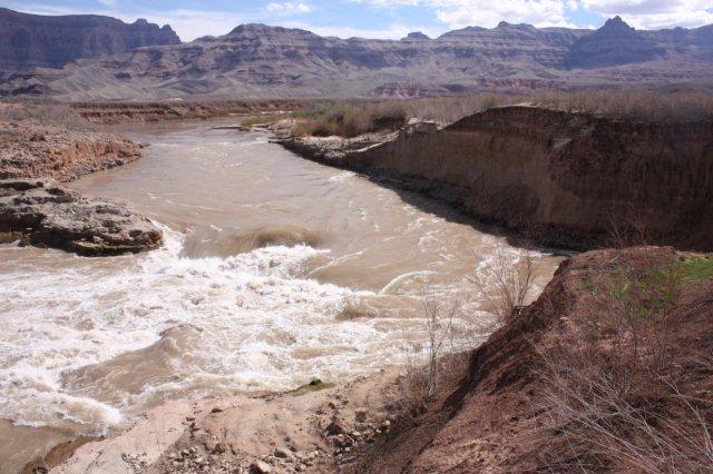
Update as of Sept. 22, 2010
The two photographs below were taken on Sept. 17, 2010. If you click on either photograph you can see a large version of each.

The photograph above looks southeast from “North Ridge” and shows the east side of the rapid – right side as you are looking downstream.

The photograph above looks south-southeast from “North Ridge” and shows the west side of the rapid – left side as you are looking downstream.
What was originally just a rock in the middle of the river is gradually revealing itself as a ledge that extends across the entire river. As the river erodes downward, the exposed portion of the ledge is steadily extending westward. (Toward the left side of the river as you are looking downstream.)
If you click on either photograph, you will get a large version that shows more detail. The rock ledge has interleaved layers of silt and conglomerate cobbles that were deposited some 10 to 15 million years ago. Rocks and cobbles in the conglomerate layers were washed in by local flash floods. Silt layers (without imbedded rocks) were deposited by mud settling out of a shallow lake.
The layers that can be seen in the ledge were subsequently buried by another ~1,800 feet of sediments in what was a closed basin up until about 5.4 million years ago. (The old level top of these sediments is still present at the dirt airstrip about 4 miles southwest of the rapid – see bottom edge of the NASA photos at top of page.) Finally, the Colorado River relocated to its present course about 5.4 million years ago, and has been busy excavating the whole works (including cutting the Grand Canyon) ever since.
Update as of April 24, 2011
The two photos below were taken on April 23, 2011 by Steve Roberts.
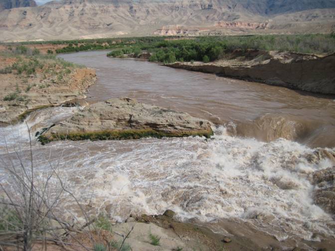
The picture above looks upstream to include the east side of the rapid. The channel on the east side of the rapid was navigable a couple of years ago, but it’s now just a small waterfall that bounces off a couple of ledges.
The picture above shows the main part of the rapid - which flows to the west side of the large rock. This portion of the river has also eroded down to a series of ledges. There doesn’t appear to be any navigable route other than bouncing off a ledge or two followed by a plunge into the deepening “hole”.
Update as of May 27, 2016
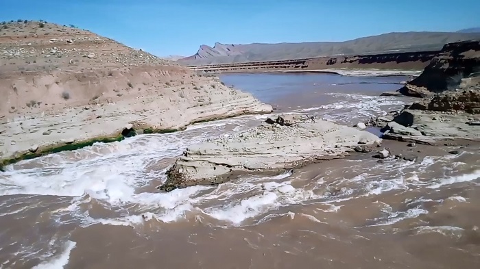
The PrintScreen picture above is from a March 4, 2016 video by Russell Dudley that can be seen at https://www.youtube.com/watch?v=wJ1W1kZIMQ8 . The view looks northward (downstream) from the west (left) bank of the river.
There appears to be at least 10 feet of downward erosion since the rapid started to form some 9 years ago.
Update as of July 26, 2017
The picture above is a Print Screen image from a video by Tom Martin as uploaded to YouTube. https://www.youtube.com/watch?v=5IsoIJ_UqvU It shows what the rapid looked like as of Feb. 26, 2017.
In the last year, the river has cut down several feet just to the west of what used to be the large rock that split the river’s flow. The result is that the entire river is now squeezed into a narrow slot estimated at 40 feet wide. Given the turbulence and sand load of the river, continued rapid down cutting is likely, along with some erosion back upstream.
The rapid will probably not be runnable by rafters until either 1) the water level in Lake Mead rises enough to submerge the rapid (not likely for at least the next 2 years), or 2) the river can erode upstream to where it is clear of the silt buried ridge.
The Future
If we look still further out into the future over the next couple of decades, Superimposition Rapid will just be a temporary phenomenon. Even with Glen Canyon Dam blocking the silt flow that used to come down the Colorado River, there is still an inflow of silt from the Paria, the Little Colorado, and smaller tributaries. This silt will continue to accumulate in what used to be the upper end of Lake Mead. The exact details of where and when this new silt will settle out will vary with the water level in Lake Mead, but the new silt will eventually bury everything that is visible today. This will include Superimposition Rapid, which will eventually be buried - never to reappear again.
Iceberg Reef
Rapids
alternately
Iceberg Rapids
alternately
Iceberg Rapids
The photo above was taken by Andy Pernick of the U. S. Bureau of Reclamation on April 25, 1997.
http://www.usbr.gov/lc/region/g5000/photolab/gallery_detail.cfm?PICIDTYPE=4571
The view looks NNE up Iceberg Canyon when Lake Mead was nearly full (water level 1200 feet), and before silt filled Iceberg Canyon. The site of the uppermost Iceberg Reef Rapid/Iceberg Rapid (Devils Cove Rapid - the “Wave” of 2008) is about “one island length” to the right of the elongated island that can be seen near the left edge of the photo. What appears as an island in this photo is the white colored point to the left of the incipient Devils Cove Rapid in the next photo.
The sediment that is brought down by the Colorado River continues to build a delta out into Lake Mead. This sediment has buried the old river channel under some 300 feet of mud/silt. As the water level in Lake Mead drops lower, the river establishes new channels across these silt flats. Since the river has no guidance as to the location of the old channel, the new channels meander randomly across the silt flats - and in the process these new channels occasionally end up relocating over the top of old buried ridges. Then, as the water level in Lake Mead drops, the river hangs up on the hard rock of the old ridges and “pour-over” rapids develop on the downstream side.
The original copy of the above photo was taken by Andy Pernick of the U. S. Bureau of Reclamation on Jan. 8, 2009. The original picture (which includes better detail) can be downloaded from:
http://www.usbr.gov/lc/region/g5000/photolab/gallery_detail.cfm?PICIDTYPE=26594
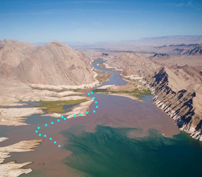
The view looks toward the NNE up Iceberg Canyon. The original river channel hugged the cliffs on the right (east) side of Iceberg Canyon. However, the river has formed a new course as indicated by the blue dots. Areas where the new course of the river crosses over buried ridges are indicated by paired dots. The dots represent the estimated path of the river as of July 1, 2009. (Also see topo maps and photo below.) The river’s course is subject to change with no advance notice - which should be borne in mind by anyone running the river.
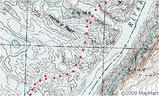
These two topo maps (above and below) show the same area as the aerial photograph except the estimated course of the river is shown by red dots. (Red dots show up better than blue dots.)
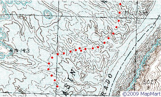
The most northerly of the paired dots is Devils Cove Rapid - otherwise known as “The 2008 Wave” which surfaced during the summer of 2008. At that time, the upper end of Lake Mead was just a short distance to the southeast. During the winter of 2008/2009 the water level in Lake Mead rose several feet and submerged the wave - as shown in the Jan. 8, 2009 photo.
By the time the lake level dropped again in 2009, additional layers of silt had been deposited. The delta now extended an additional mile beyond the 2008 position and the river developed still another new course.
A second rapid (Burro Spring Rapid) formed about 0.6 miles SSW of Devils Cove Rapid where the new course of the river crossed another old buried ridge. This location is shown by the second set of double dots in the above photo and topo maps. The possibility exists that a third rapid may develop still further downstream where the river makes a close approach to another ridge in the lower left corner of the above photo.
The photo to the right was taken by Tom Martin about July 1, 2009. Tom took additional photos of the rapids in this area, and these can be seen at: http://www.rrfw.org/gallery/index.php
 The view looks SSW over
the new rapids with the south end of Iceberg Canyon in the extreme
lower right corner. The persistently shrinking Lake Mead can be
seen in the upper left quadrant with Sandy Point sticking out into
the lake from the left (east) shore line.
The view looks SSW over
the new rapids with the south end of Iceberg Canyon in the extreme
lower right corner. The persistently shrinking Lake Mead can be
seen in the upper left quadrant with Sandy Point sticking out into
the lake from the left (east) shore line.The uppermost of the two new rapids (Devils Cove Rapid) is in the lower right portion of the photo just above the green vegetation patches that bracket the river, and just below the large sandy area to the left of the river. In between these two locations, the river crosses a sediment-buried ridge that is part of Iceberg Reef.
This rapid emerged briefly in the summer of 2008 and for a while formed “The Wave”. The ridge that the river crosses shows up as the small elongated island that was visible in the 1997 photograph.
In the Jan. 2009 photograph, there was a large muddy area where the river was building its delta out into the lake. By July 1, 2009 the lake level had dropped some 15 feet. The mud was exposed and subsequently dried out to form the whitish sandy area in the July 1 photograph.
Meanwhile, the river extended its path further out into the lake, and in the process, crossed another buried ridge. As the lake level dropped, the river eroded down thru the silt and sediment until it hung up on the top of the old ridge. A new rapid, Burro Spring Rapid is the result. Its location can be seen in the photo where the river turns to the right and exits the sandy area. ( A close-up of Burro Spring Rapid can be seen at: http://www.rrfw.org/gallery/index.php )
Hiatus – Jan. 11,
2012
The photo above was taken on Jan. 3, 2012 by Brady Black and posted in the Mountain Buzz forum at http://www.mountainbuzz.com/forums/f11/pearce-ferry-rapid-35506-7.html There was still a noticeable current at the rapid, but this was due to the channel constriction between the rock and “North Point” as opposed to any elevation drop of significance at the rapid.
Despite the current low snowpack levels in the Rockies, Lake Mead is expected to rise a little higher yet than what prevailed at the beginning of 2012. This plus the unrelenting silt accumulation should mark the end of the rapid.
R.I.P. oh mighty rapid.
May 2015 Update
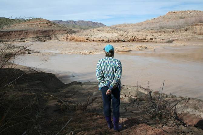
The continued long term drought in the southwest has caused Lake Mead to drop to its lowest levels since it was being filled in the 1930s. The rapid at Peace Ferry is fully exposed and is quite severe again. A new rapid may develop a short distance upstream from the former Driftwood Island ( See http://www.durangobill.com/GCTourLowerSuperimposition.html )
“The Wave” rapid just below Iceberg Canyon should be fully exposed and may become severe by late summer 2015. (And may be unrunnable in 2016.) It looks like river current exists until you pass Sandy Point. South Cove may become unreachable by boat by 2030, and almost definitely by 2035.
May 2022 Update
The Colorado River appears to be doing a Yeoman's job of cutting down through the ~ "soft" sandstone layers of the old ridge that the Colorado River pours over to form the rapids. As this old rock barrier is eroded away, the river can eat its way lower into the sediments at the current Pearce/Superimposition raft take-out point. Thus the drop-off to river level will become greater with time. A rough estimate would indicate about a foot of "river digging" per year which will make it increasingly difficult to hoist rafts out of the river. By the year 2030, it may be necessary to bulldoze/dig some kind of a ramp to allow access to the river.
Origin of this
Web Page
There is a mythology about the origin of scientific investigations regarding any subject. Cartoons sometimes show someone in a white coat shouting “Eureka! I’ve found it!”
In reality, it’s closer to stumbling upon an unexpected anomaly and not knowing what caused it. (As in a quizzical: “That’s funny?”) This leads to a sequence of questions such as What?, Why?, etc. Curiosity about the What?, Why?, etc. is followed by a little research to try to find out what is going on and what it might lead to.
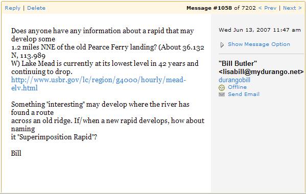
The picture above is a Print Screen image of a message that the author posted in Yahoo’s “Grand Canyon Rafting” Group back in June 2007 – and now you know the rest of the story.
Notes on the
origin of the name “Pearce Ferry”
(Click on picture for a large version)
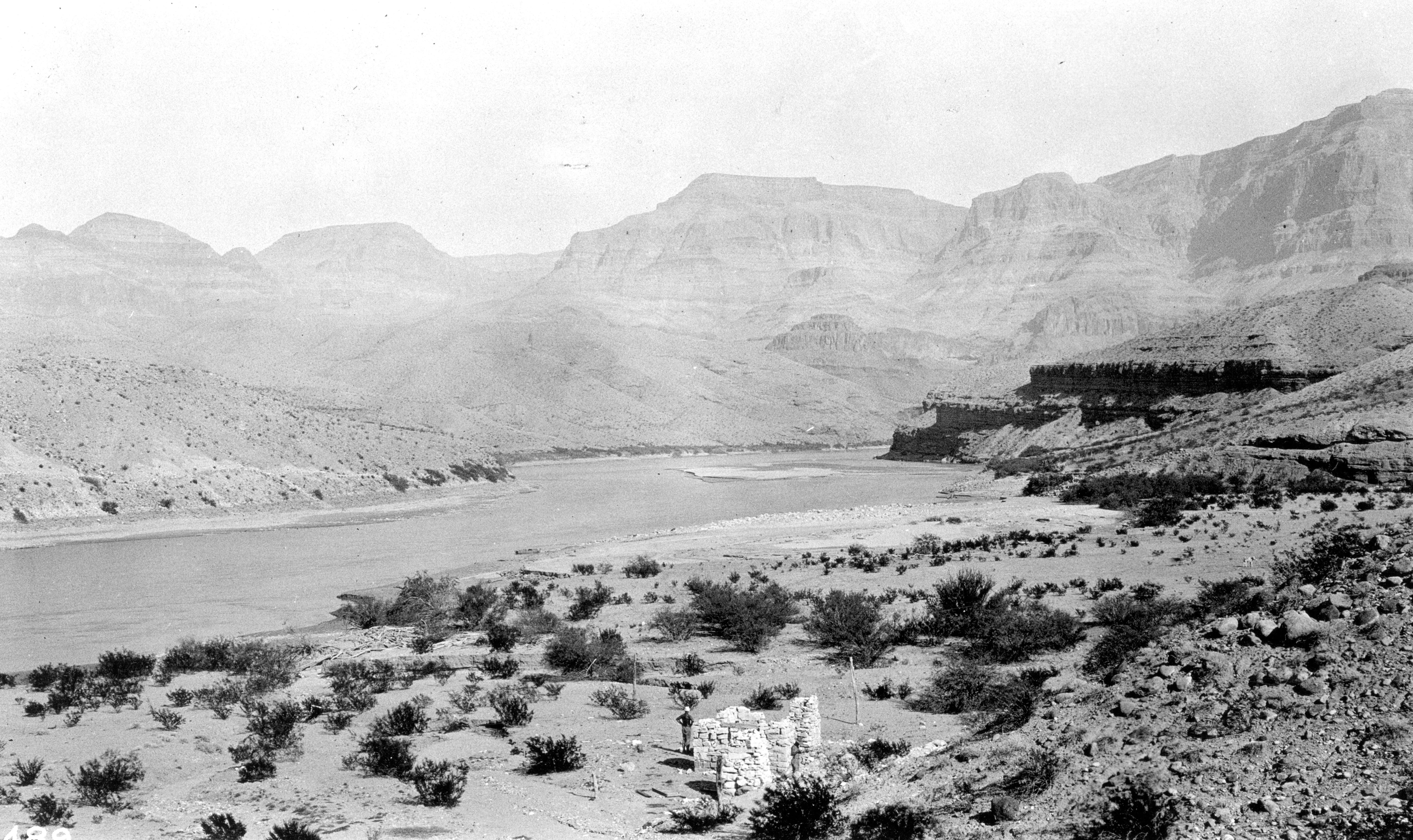
“Grand Canyon National Park,
Arizona. Upstream toward the west portal of the Grand Canyon.
Note the ruins of the old stone house in the foreground. This
was once one of the buildings at Pierce (Pearce) Ferry, where a
wagon trail from Kingman to Moapa crossed the river. Colorado
River Survey of 1923 (Birdseye).”
The historic photograph above was originally taken on the “Colorado River Survey of 1923” and was subsequently published in the May 1924 issue of National Geographic Magazine. You can see the original photo at http://libraryphoto.cr.usgs.gov/cgi-bin/show_picture.cgi?ID=ID.%20LaRue,%20E.C.%20%20771
The estimated location of the photographer is about 36.130 N, 113.977 W or about 0.63 miles east and a little south of the developing Superimposition Rapid. (Please see the pin location in the first Google Earth picture.) The view in the 1923 photograph looks slightly north of due east. Based on the estimated location of the photographer and the location of the river in the photograph, it is estimated that the river originally turned toward the north just off the left edge of the photograph, and passed about one-half mile to the east-northeast of the new rapid.
After Hoover Dam was built, the old river channel was buried under 300 feet of silt and sediments brought down by the Colorado River. You can get some idea of the magnitude of 300 feet of sediment by following the ridge that starts in the dark shadow next to the river and climbs to where it disappears off the right edge of the photograph. The uppermost portion of this ridge (just off the right edge) remains barely above the silt flats. If you look at the first Google Earth picture, you can see a small light-colored “sand island” to the right and a little below the pin location. The “sand island” is the top of the ridge that is just off the right edge of the 1923 photograph. Also, the “sand island” is visible just to the right of the river in the middle distance in the first 2006 Bureau of Reclamation photograph.
The picture above was generated by Google Earth and shows approximately the same view (with slightly wider sides) as the old 1923 photograph, except that as of 2004, the viewpoint is some 300 feet higher due to the influx of silt. In the Google Earth picture, the low flat area on the skyline to the left of center appears relatively higher due to the ~300-foot increase in viewpoint elevation. Most of the skyline is formed by the inner rim (Grand Wash Cliffs), but the low flat area is part of the outer rim and is some 5 - 6 miles more distant (and 1,900 feet higher) than the inner rim. Thus the increase in viewpoint elevation makes it appear somewhat higher in the Google Earth view vs. the 1923 photograph.
The name “Pearce Ferry” goes back to 1876 when Harrison Pearce established a ferry service here to cross the river. There is good original documentation at:
http://search.ldslibrary.com/article/view/2579935
and
http://www.familytreelegends.com/records/45546?c=read&page=118
The spelling of “Pearce Ferry” was subsequently corrupted to “Pierce Ferry”. (The “spelling checker” in Microsoft Word didn’t exist yet.) While “Pearce Ferry” (also “Pearce’s Ferry”) is the original name, “Pierce Ferry” is widely used.
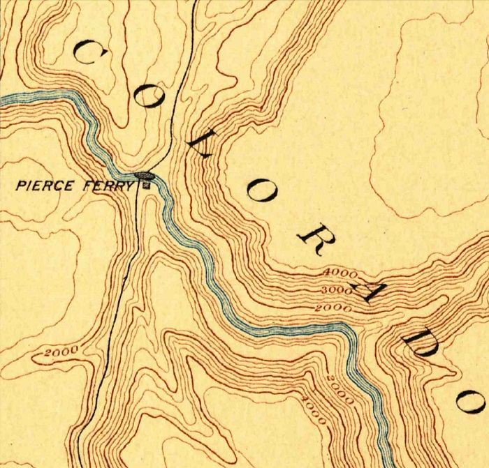
The picture above is a portion of the USGS 1892 “Mt Trumbull” topographic map. The river flows from the Grand Canyon in the lower right corner up toward the upper left corner where it turns left through Wheeler Ridge before exiting off the upper left edge. The original of this and other archived USGS maps can be seen at:
http://store.usgs.gov/b2c_usgs/usgs/maplocator/(xcm=r3standardpitrex_prd&layout=6_1_61_48&uiarea=2&ctype=areaDetails&carea=%24ROOT)/.do
Note: The above USGS link apparently doesn't carry the old Mt. Trumbull map any more, but it is available at http://historicalmaps.arcgis.com/usgs/
USGS maps in 1892 didn’t have anywhere near the accuracy of present day maps, but when you think about it, any reasonably accurate map in 1892 was a major accomplishment. The old wagon trail from Kingman to Moapa is marked on the map as well as the location of Pearce (Pierce) Ferry.
Return to river miles 272 to 280
Continue to the Lower Superimposition Rapid page
Return to the Index Page for the Grand Canyon Tour
Web page generated via Sea Monkey's Composer HTML editor
within a Linux Cinnamon Mint 18 operating system.
(Goodbye Microsoft)