
Durango Bill's
Grand Canyon 3-D Tour
River Mile 272 to the Grand Wash Cliffs and Lake Mead
Grand Canyon Miles 272 to 280
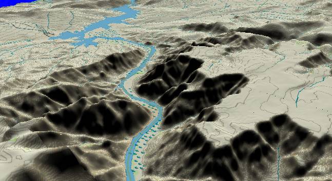
View to the
north-northwest with river mile 272 at the lower edge. The
Grand Wash Fault runs across the picture from the center of
the left edge to the upper right corner. Strata on the western
side have been faulted downward by at least 10,000 feet. Open
areas of Lake Mead are in the distance. Pearce Ferry (near the
upper left corner) used to be the takeout point for Grand
Canyon raft trips. (The Stevens Grand Canyon Guide uses
"Pierce Ferry", but the USGS topo quads stick to "Pearce
Ferry". Note: In Aug. 2001 the lowering water level in Lake
Mead forced Pearce Ferry to close indefinitely. The takeout
destination for all raft trips is now South Cove, and the
continued drop in water levels may put it in jeopardy. Also,
the current size of Lake Mead is greatly reduced from that
shown in the picture.)
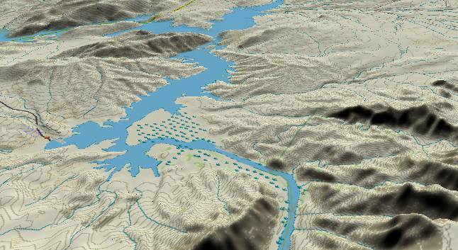
As of May 2003, most of the lake shown above has essentially dried up. Before Lake Mead backed up into this area, the river cut across the mud flats to the right of Pearce Ferry Cove. (The old channel is 300 feet down under the current surface.) Now that the water level has dropped, the river is stuck in a new channel that cuts across a former low ridge to the left of the old channel. This ridge has now become exposed and a new riffle has developed on the down slope side. If Lake Mead continues to drop, this riffle has the potential to develop into a major rapid. Over the next few years, the river channel from Wheeler Ridge (just below the top edge) upstream to Separation Canyon will be subject to changes as the river erodes down into the accumulated silt beds.
The Grand Wash Cliffs are a dividing line between the Colorado Plateau to the east and the Basin and Range system to the west. The Colorado Plateau is characterized by mesas with incised canyons while the Basin and Range zone features fault block mountains and dropped basins. The topography of the Basin and Range is dominated by crustal stretching.
August 29,1869 - "We start very
early this morning. The river still continues swift, but we
have no serious difficulty, and at twelve o'clock emerge from
the Grand Canyon of the Colorado."
Powell Report
Return to river miles 264 to 272
Continue to “Superimposition Rapid”
Return to the Index Page for the Grand Canyon Tour
Web page generated via Sea Monkey's Composer HTML editor
within a Linux Cinnamon Mint 18 operating system.
(Goodbye Microsoft)
Powell Report
Return to river miles 264 to 272
Continue to “Superimposition Rapid”
Return to the Index Page for the Grand Canyon Tour
Web page generated via Sea Monkey's Composer HTML editor
within a Linux Cinnamon Mint 18 operating system.
(Goodbye Microsoft)