
Durango Bill's
Paleogeography (Historical Geology) Research
Grand Canyon - Colorado River Gradient
A Trace Showing River Elevation and Gradient Through the Grand Canyon
The graph below shows the
elevation of the Colorado River and its downstream gradient as
it flows from Lees Ferry to Lake Mead through the Grand
Canyon. Dark red and dark blue data for the graph were taken
from USGS Topographic maps combined with the Martin &
Whitis “Guide to the Colorado River in the Grand Canyon”.
(Better detail is available at TopoZone http://www.topozone.com
although the maps are the same.) The USGS maps show 40-foot
contours with interpolations by the author.
Prior to July 21, 2007, an older graph was used that was based on contours in Belknap’s River Guide. Both sources are roughly similar although there are some minor differences over short ranges. Similar data (in orange and light blue) has been added to show what existed before Lake Mead backed up into the lower canyon. Light colored lines to mile 261 are from Larry Stevens’ “The Colorado River in Grand Canyon”. Data to mile 280 is an interpolation based on a pre Lake Mead USGS topographic map that shows 870 feet at Wheeler Ridge (Mile 284).
Prior to July 21, 2007, an older graph was used that was based on contours in Belknap’s River Guide. Both sources are roughly similar although there are some minor differences over short ranges. Similar data (in orange and light blue) has been added to show what existed before Lake Mead backed up into the lower canyon. Light colored lines to mile 261 are from Larry Stevens’ “The Colorado River in Grand Canyon”. Data to mile 280 is an interpolation based on a pre Lake Mead USGS topographic map that shows 870 feet at Wheeler Ridge (Mile 284).
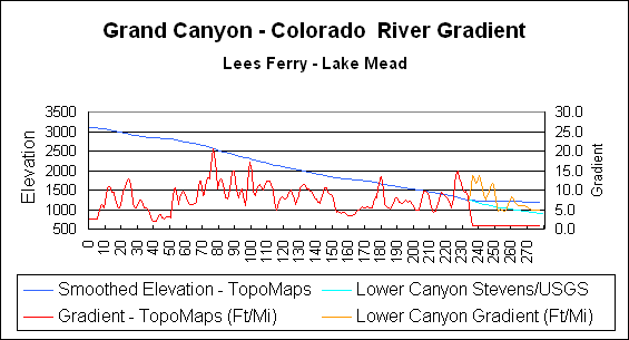
The table below interprets some
of the observations.
Mile 0: Lees Ferry
Mile 22 to 26: There are several rapids in this area, but they appear to be a result of the steeper gradient rather than the cause of the gradient. The rock layers in this area are the lower members of the Supai Group and the top of the Redwall Limestone. The steeper gradient in this section appears to be the result of a small recently-active fault that crosses the river at mile 30. The downstream side of this fault has been dropped 50 to 100 feet. The gradient is thus increased as the river crosses the fault zone. The increased gradient then works its way back upstream as canyon cutting propagates upriver. If the solid Redwall Limestone influenced the gradient, then the gradient should decrease instead of increasing in this area.
Mile 37 to 50: This area has the least gradient observed in the Grand Canyon. The Eminence Break Fault crosses the river at mile 49.8 with the strata uplifted downstream. It appears this fault has also been active in the recent past. The uplift downstream from mile 50 acts as a partial barrier to river erosion with the result the gradient is less as the river approaches the uplifted barrier.
Mile 71 to 79: The steepest gradient within the canyon is observed in this section. The gradient increases sharply after mile 71, but this is not due to local rock conditions, as the Vishnu Schist isn't seen until mile 78 and even the Shinumo Quartzite doesn't appear until mile 75. The crest of the Kaibab Anticline is well to the west of this area. The pattern is consistent with the river acting as a "stationary band saw", and cutting a gorge into a still rising block. The peak gradient occurs at Hance Rapids between miles 76 and 77.
Mile 98 to 99: The local peak in the gradient (to above 15) is entirely due to a "little river riffle" at the mouth of Crystal Creek. A photo on page 376, Beus and Morales, shows a large river raft being swallowed by an even larger 5-6 m. standing wave at Crystal Rapid in June 1983.
Mile 152 to 175: This section of the river has the least gradient of any area west of the Kaibab Plateau. Intuitively, this area should show a steep gradient as it is just above the Toroweap Fault and includes some of the sheerest parts of the inner canyon. It seems probable a major debris flow in Prospect Canyon some 3,000 years ago created Lava Falls Rapid, and the debris fan has been partially blocking the river for 20 miles upstream ever since.
Mile 179 to 180: Everyone's favorite "riffle" otherwise known as Lava Falls Rapid. This was the greatest obstacle to the Racing Chris Crafts that ran the river upstream in 1950. It took several hours before they made it. Earlier (unsuccessful) motorized attempts to run Lava Falls upstream were filmed with narration by a then unknown commentator who has since gone on to making a ski movie or two. (Hint - W. M.)
Mile 225 to 231: The river has one last steep section before entering the backup from Lake Mead. This is sort of the “Home Stretch” as the river approaches the Grand Wash Cliffs. Before Hoover Dam was built, there were several more rapids (steep gradient) from here to the Grand Wash Cliffs.
Mile 235 to 242: (River elevations and gradient are derived from The Stevens Guide Book and an old USGS topographic map that shows the pre Lake Mead elevation at River Mile 284.) The old riverbed in this area is buried by the backup from Lake Mead. Before Hoover Dam was built, the gradient in this section (Lower Granite Gorge) rivaled the current gradient observed in Upper Granite Gorge.
Return to the Image Index Page
Web page generated via Sea Monkey's Composer HTML editor
within a Linux Cinnamon Mint 18 operating system.
(Goodbye Microsoft)