
Durango Bill’s
Grand Canyon 3-D Tour
Near River Mile 286.2
Lower Superimposition Rapid
alternately
Driftwood Rapid
(Also please see Superimposition Rapid)
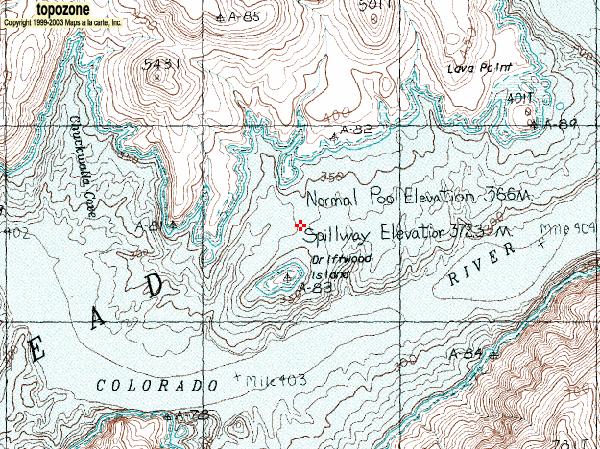
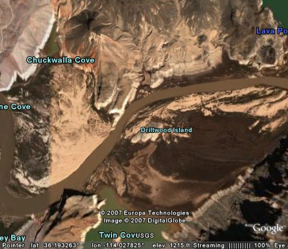
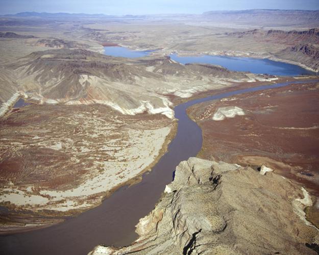
The topographic map above (Courtesy of TopoZone http://www.topozone.com/ ) shows the pre-Lake Mead contours in the vicinity of “Driftwood Island”. (Driftwood Island is just below the center of map.) The blue shading shows what Lake Mead would cover if it were full. Contour elevations are in meters - thus multiply by ~3.28 to convert to feet. If you want to find Driftwood Island via Google Earth, go to about 36.1926 N, 114.0269 W. (Note, the mile markers in the above map do not correspond with current Grand Canyon river guide maps.)
There are two items of interest in the map. First, the pre-Lake Mead course of the Colorado River was from right to left in the deepest part of the old canyon. (The contour lines in this deepest part of the old canyon average about 270 meters which is equivalent to about 886 feet above sea level.) In particular, note that this old route was south of Driftwood Island. The second item of interested is the red place-marker. It is located on the crest of an old ridge at an approximate elevation of about 343 meters which is about 1125 feet above sea level. Before Lake Mead existed, this old ridge connected what would become Driftwood Island with higher elevations to the north. We will come back to this “red place-marker”.
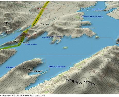
After Hoover (Boulder) Dam was built, the upstream reservoir (Lake Mead) backed up until only a small speck remained of the “Driftwood Island Ridge”. In the computer generated picture above, Driftwood Island is the small unlabeled island in the center. Meanwhile, the Colorado River continued doing what it had been doing for millions of years. It was transporting silt downstream - only now the silt was being trapped in Lake Mead instead of continuing down to the Colorado’s delta. As measured near Phantom Ranch in the Grand Canyon, this silt transport rate averaged 3 to 5 tons per second. (Different sources give different amounts.) This went on for 60 seconds per minute. 60 minutes per hour. 24 hours per day. 365 days per year. For decades. The subsequent construction of Glen Canyon Dam has significantly slowed this sediment transport rate (now Lake Powell is catching most of the sediment), but for nearly 30 years, Lake Mead got “dumped on”.
The incoming sediment buried the old river channel some 300 feet deep. It also spread sideways to cover the old ridge that connected Driftwood Island with higher terrain to the north.
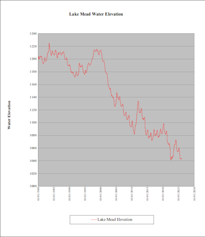
In the last few years, the southwestern part of the United States has been experiencing a drought. Inflow to Lake Mead has been less than what downstream demands wanted. Thus, water has been released from Lake Mead to make up the difference. The excess of outflow over inflow has lowered the lake level.
As the water level in Lake Mead has dropped, the huge amounts of silt that were deposited are being exposed. There is one very important difference from the topographic map view (first picture). In the topographic map view, the original course of the Colorado River was to flow from right to left to the south of Driftwood Island. In the recent Google Earth view above, the Colorado River is still flowing from right to left, but now it is north of Driftwood Island.
As discussed on the Superimposition Rapid Page, the process of burying an old landscape with sediment and then establishing a new drainage system on top of it has a descriptive name. What we are witnessing here is another example of “superimposition”. While it only took a few decades instead of many million years, a new drainage system has been established on the surface of the recently deposited sediments.
Once again, the new drainage system had no information about the old river channel. Here, by random chance, the new path for the river ended up over the old Driftwood Island Ridge. The high saddle point on the old ridge is about 1125 (+/-) feet above sea level, as shown by the “red place-marker” on the topographic map.
The photograph above is part of the Bureau of Reclamation’s Photo Database. The original photograph can be seen here: http://www.usbr.gov/lc/region/g5000/photolab/gallery_detail.cfm?PICIDTYPE=13210
The view looks northeastward with Driftwood Island (now a sandy hill) a little to the right of center and Grand Wash Bay in the distance. The Colorado River enters from the upper right and flows toward the lower left. Lower Superimposition Rapid is a “potential rapid”. As of early 2008, it doesn’t exist. However, if the water level in Lake Mead should drop below the 1100-foot level, then the rapid would develop where the river crosses a submerged ridge that extends from Driftwood Island to higher ground above and to the left of the former island.
In mid 2007, the outlook for Lake Mead called for the Lake Mead water level to drop to 1100 feet (or lower) over subsequent years. If subsequent events had followed this scenario, the river would have had no problem excavating a lot of the old silt downstream from the Driftwood Island Ridge. The material in the ridge itself is probably poorly cemented, but it has been in place for several million years. It would resist erosion whereas as downstream silt could be eroded. Potentially, another “superimposition type” rapid could develop on the downstream side of this ridge. If Lake Mead water levels should drop below the 1100-foot level sometime in the future, a rapid would form at this location, and it would seem appropriate to name this rapid:
Lower
Superimposition Rapid
The winter of 2007/2008 had above normal snowfall in the Rockies. Runoff from this snowfall will keep water levels in Lake Powell and Lake Mead well above earlier expectations. Thus “Lower Superimposition Rapid” will only remain as a potential rapid that is subject to possible lower water levels in Lake Mead at some indeterminate time in the future.
The Calm Before
the Storm
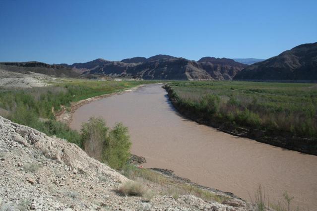
The photograph above was taken by Tom Martin on Oct. 9, 2007. The photographic location is part way up a small bluff about 1200 feet northwest of the top of the former Driftwood Island and looks east-northeastward toward Wheeler Ridge. Grand Wash Canyon is to the right of center.
If the water level in Lake Mead should ever drop to the 1100-foot level, Lower Superimposition Rapid (Driftwood Rapid) would begin to form about 1100 feet upstream - approximately to the right of the white bluff that can be seen on the left edge of the picture. The location would be near the area where there is a slight change in the river color from “light muddy” in the foreground to “dark muddy” in the background.
Up until Jan, 2008, the USBR had been forecasting Lake Mead to drop below the 1090 foot level in 2009. If this had worked out, a significant rapid would begin to form on the north side of Driftwood Island. However, snowfall amounts in the Rockies were significantly above normal during the winter of 2007/2008. This produced a larger water runoff and will keep Lake Mead at higher levels in 2008/2009 than expected earlier. It now looks like nothing will develop on the north side of Driftwood Island for the next couple of years; but if Lake Mead should ever drop to below the 1100-foot level at some future date, the potential remains that “Lower Superimposition Rapid” could still form.
October 2017 Update
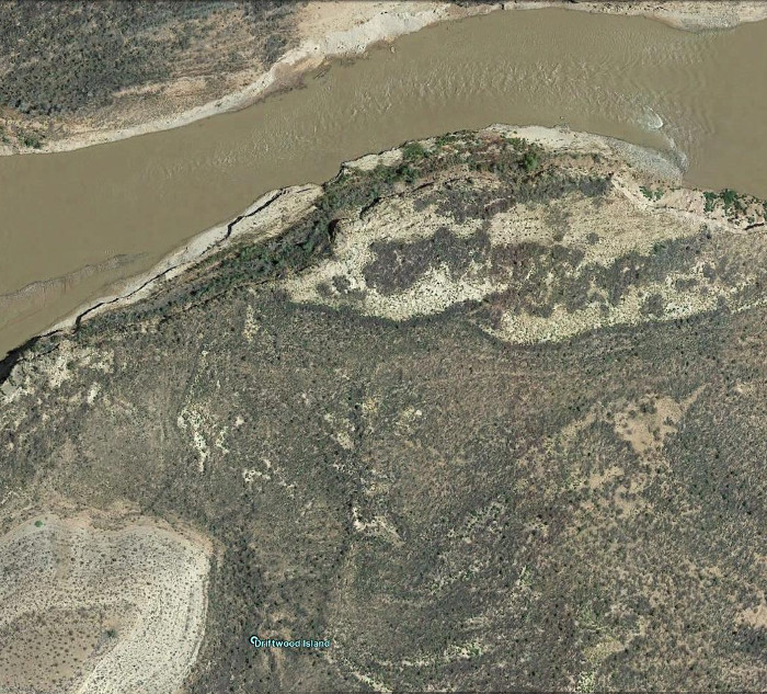
The picture above shows that a riffle has appeared to the northeast of the old Driftwood Island where the Colorado River crosses an old buried ridge. The riffle is upstream (left) of the top of the old ridge showing that the river has eroded into the poorly consolidated (easily eroded) rock of the old ridge.
Return to the Superimposition Rapid page
Return to the Index Page for the Grand Canyon Tour
Web page generated via Sea Monkey's Composer HTML editor
within a Linux Cinnamon Mint 18 operating system.
(Goodbye Microsoft)