
Durango Bill's
Grand Canyon 3-D Tour
Tincanebitts Canyon to River Mile 272
Grand Canyon Miles 264 to 272
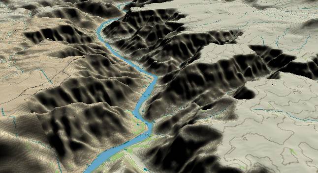
View to the
northwest with Tincanebitts Canyon joining the Colorado River
near the middle of the bottom edge. Dry Canyon continues off
the right edge while the river turns to the left.
The Precambrian and Tapeats layers have dropped below the river level. Thus the strata in this picture range from the flat Esplanade surface, down through the various limestone layers to the Bright Angel slope next to the river.
After the Hoover (Boulder) Dam was built, Lake Mead was allowed to rise to the dam’s maximum capacity. Silt coming down the river was deposited at this maximum lake level and covered a large part of the Bright Angel Shale next to the river. After Glen Canyon Dam was built, Lake Mead was lowered by about 50 feet leaving the silt layers slightly above the new water level. Tamarisk (A large bush that was introduced into the Southwest from the Mediterranean area before 1900) has proliferated in these silt flats and grown into a nearly impenetrable jungle next to the river.
There is a large cave in the cliffs on the right side of the river (near the center where the river turns left a second time) that was mined for bat guano until the 1950s. Remnants of the mining operation can still be seen from the river. Additional information (including the story about the “jet jockey” from Nellis Air Base clipping the tramway cable) is available at http://www.meadview.info/batcave.htm and http://www.kayakplace.com/essay/gc/gc03-8.htm.
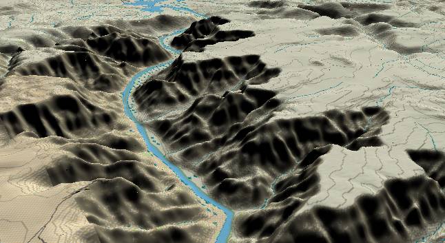
View to the
northwest with the Bat Cave mining operations cliff next to
the right side of river at the lower edge. Most of the canyons
in this area haven't been named yet, and there are no named
landmarks at river mile 272 (at the far end of the river's
gradual turn to the right). In the far distance the Grand
Canyon comes to an abrupt end west of the Grand Wash Cliffs.
Canyon topography is still impressive as the cliffs rise about 3,600 feet above the Colorado River.
Return to river miles 256 to 264
Continue to river miles 272 to 280
Return to the Index Page for the Grand Canyon Tour
Web page generated via Sea Monkey's Composer HTML editor
within a Linux Cinnamon Mint 18 operating system.
(Goodbye Microsoft)