
Durango Bill's
Grand Canyon 3-D Tour
S B Point to National Canyon to Fern Glen Canyon
Grand Canyon Miles 160 to 168
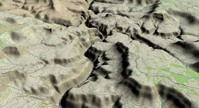
View to the
west-southwest with S B Point (North Rim) in the lower right
quadrant and Tuckup Canyon just above it.
The Colorado River flows gently for a 20-mile stretch from here until Lava Falls Rapid at river mile 179. There are few rapids in this section and river gradient averages only 5 feet per mile (The least gradient on the west side of the Kaibab Plateau). The steep narrow inner gorge implies there should be rapid down-cutting in this area. Also, this area is on the up thrown side of the Toroweap Fault Zone, and you would think that canyon cutting would be active from here westward to the fault. Yet the river is placid. Actually, there probably was rapid down-cutting through this section of the Grand Canyon until about 3,000 years ago. Then something happened to change things. We will revisit this scenario when we get to Prospect Canyon at river mile 179.
The Colorado River flows gently for a 20-mile stretch from here until Lava Falls Rapid at river mile 179. There are few rapids in this section and river gradient averages only 5 feet per mile (The least gradient on the west side of the Kaibab Plateau). The steep narrow inner gorge implies there should be rapid down-cutting in this area. Also, this area is on the up thrown side of the Toroweap Fault Zone, and you would think that canyon cutting would be active from here westward to the fault. Yet the river is placid. Actually, there probably was rapid down-cutting through this section of the Grand Canyon until about 3,000 years ago. Then something happened to change things. We will revisit this scenario when we get to Prospect Canyon at river mile 179.
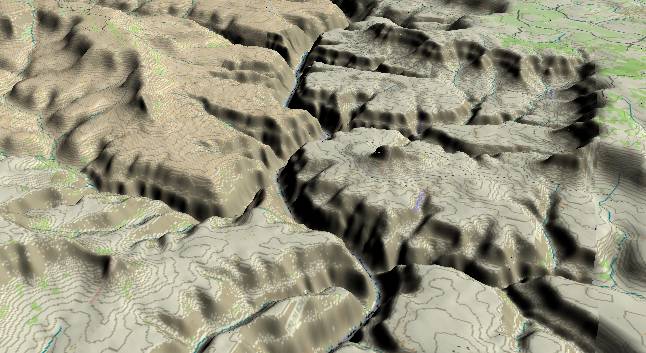
View to the
west-southwest with Tuckup Canyon entering the Colorado
River near the lower right edge. National Canyon enters from
the left edge and joins the river a mile and a half below
Tuckup. The small butte on the Esplanade surface just above
the Tuckup Canyon junction is "The Dome". The Dome is an
isolated remnant of the north rim and has near vertical
sides of Coconino Sandstone. The next canyon beyond (above)
The Dome is Fern Glen Canyon.
In the far distance a diagonal line extends from the upper left edge, crosses the river, and continues just this side of another segment of the North Rim. Twin canyons have evolved along the Mohawk-Stairway Fault.
National Canyon is another interesting hike if you are rafting the canyon. It is usually dry where it joins the Colorado, but if you hike up it you will usually find a small clear stream. A little further up the canyon there is a refreshing pool sandwiched between rock walls.
Return to river miles 152 to 160
Continue to river miles 168 to 176
Return to the Index Page for the Grand Canyon Tour
Web page generated via Sea Monkey's Composer HTML editor
within a Linux Cinnamon Mint 18 operating system.
(Goodbye Microsoft)