
Durango Bill's
Grand Canyon 3-D Tour
Fern Glen Canyon to Toroweap Point
Grand Canyon Miles 168 to 176
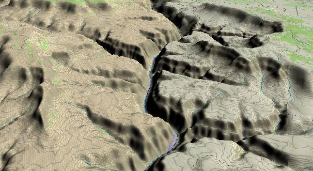
View to the
west-southwest with Fern Glen Canyon in the right foreground
and the Mohawk-Stairway (also called Stairway-Willow Springs)
Fault cutting across the center of the picture. Erosion along
the fault has generated twin canyons with Mohawk Canyon to the
left (south) and Stairway Canyon to the right. In the
distance, the Cove Canyon complex has cut into the North Rim
with Big Point near the center of the picture and Toroweap
Point near the upper edge.
The Redwall/Muav Limestone sequence still forms a massive cliff next to the river, but the character of the inner gorge begins to change as the river approaches the Toroweap Fault (extreme top edge). The strata in this area begin to tilt upward toward the west, and as a result the Bright Angel Shale resurfaces again just west of Fern Glen Canyon. The Mohawk-Stairway Fault accentuates this trend as strata west of this fault have been uplifted another 50 to 100 feet. The Bright Angel Shale in this section of the Grand Canyon contains relatively more sandstone than in areas further east, thus its slope-forming tendency is not quite as pronounced.
The Redwall/Muav Limestone sequence still forms a massive cliff next to the river, but the character of the inner gorge begins to change as the river approaches the Toroweap Fault (extreme top edge). The strata in this area begin to tilt upward toward the west, and as a result the Bright Angel Shale resurfaces again just west of Fern Glen Canyon. The Mohawk-Stairway Fault accentuates this trend as strata west of this fault have been uplifted another 50 to 100 feet. The Bright Angel Shale in this section of the Grand Canyon contains relatively more sandstone than in areas further east, thus its slope-forming tendency is not quite as pronounced.
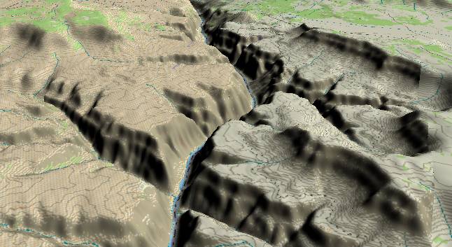
View to the
west-southwest with Mohawk and Stairway Canyons in the
foreground. The Cove Canyon Complex joins the Colorado River
near the center of the picture with Toroweap Point (North Rim)
just above it. In the distance the small conical bump near the
edge of the inner gorge is Vulcans Throne.
If you look closely just beyond the junction of Cove Canyon and the Colorado you can see the effects of Red Slide where part of the inner gorge has broken off and is slowly slumping down toward the river. The erosion process in the canyon is accomplished by the river cutting downward in its narrow path while everything else slips down the sides. The "down the sides" can be a sudden rock fall, debris flow, or slower slump, creep, etc. Once the material gets down to the river, the river grinds it up and carries it downstream. Eventually, the sand and silt are dropped in the river's delta, and a new sedimentary layer is deposited as part of some future geologic formation.
Return to river miles 160 to 168
Continue to river miles 176 to 184
Return to the Index Page for the Grand Canyon Tour
Web page generated via Sea Monkey's Composer HTML editor
within a Linux Cinnamon Mint 18 operating system.
(Goodbye Microsoft)