
Durango Bill's
Grand Canyon 3-D Tour
South Canyon to Buck Farm Canyon
Grand Canyon Miles 32 to 40
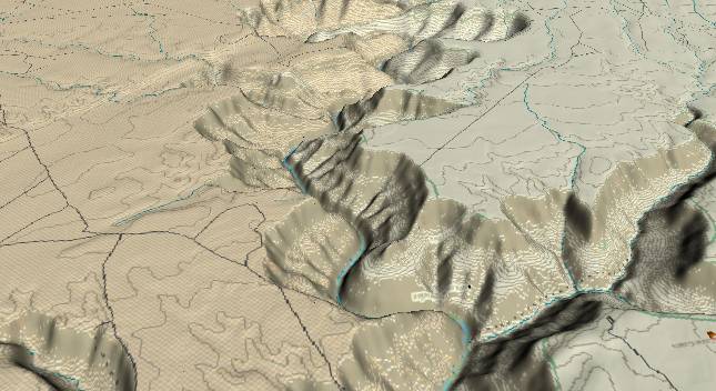
View to the
south-southwest with South Canyon in the lower right
foreground. Buck Farm Canyon extends a short distance to the
right near the top edge. The Eminence Fault enters from the
left edge (slightly above center) and just grazes the river at
the top edge.
Strata on the far side of the Eminence Fault are displaced upward by some 100 to 200 feet. The Eminence Fault has also been active recently, and thus acts as a dam to normal river flow. As a result, river gradient from the foreground until the river crosses the fault is the lowest (averages less than 5 ft. per mile) in the entire Grand Canyon. (Please see the Grand Canyon gradient for details).
At the river level the Redwall Limestone forms a sheer cliff. The Redwall characteristically has the most massive cliffs of any strata layer in the Grand Canyon, and can be easily recognized on topographic maps throughout the canyon.
One of the landmarks on raft trips is Redwall Cavern, which is located on the left side of the river halfway through the large river bend back to the right - just above the center of the lower edge of the picture.
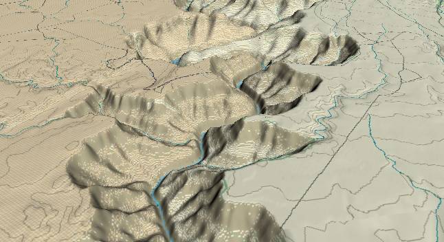
View to the
south-southwest with river mile 36 near the lower edge.
Tatahatso Wash enters from the left edge and Buck Farm
Canyon is in the distance right of center. After the river
passes Buck Farm Canyon, it makes a large meander to the
left around Point Hansbrough before continuing downstream.
The dashed line on the left rim (east side of the canyon) was an access road that was once used for surveys for a possible dam across the river. If it had been built, the whole upstream portion of Marble Canyon would have been buried under the resulting lake, and there would be no easy way for raft trips to transit the canyon.
It is interesting to note that a rim-to-rim dam at this location (plus a small dike near the Eminence Fault) would force the river to make an end run around the northwest side of the Kaibab Plateau. If a natural barrier had been here as per the hypothesis in Steven Austin's book (Grand Canyon: Monument to Catastrophe), then the Colorado River would have to go uphill for 30 river miles before it even got to the Kaibab Plateau never mind find a way to get across it. We should note that the "Young earth creationists" tend to be somewhat mathematically challenged (and/or willfully ignorant), and take all parts of the Bible literally - including Acts 13:39 ("everyone who believes is justified from all things").
Return to river miles 24 to 32
Continue to river miles 40 to 48
Return to the Index Page for the Grand Canyon Tour
Web page generated via Sea Monkey's Composer HTML editor
within a Linux Cinnamon Mint 18 operating system.
(Goodbye Microsoft)