
Durango Bill's
Grand Canyon 3-D Tour
Buck Farm Canyon to Saddle Canyon
Grand Canyon Miles 40 to 48
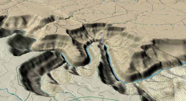
View to the east
(Note change in view direction) with Buck Farm Canyon at the
lower left and the large entrenched meander of the Colorado
River as it curves around Point Hansbrough. The Eminence Fault
is visible again extending from the upper left edge, just
grazing the river in the center, and continuing through the
point at the right edge.
The meander probably developed shortly after the Colorado River found its new path across the Kaibab Plateau some 5.4 million years ago. It is possible early activity along the fault may have contributed to a meander at this location, but it seems more likely the fault did not show any movement until the river was locked in its present path. If the fault had been active 5 to 5.4 million years ago, then there would have been an easily eroded zone along the fault, which the river should have followed. However, the fault cuts through the east rim in back of the point visible at the right edge, but the river ignores this potential path. The implication is the fault did not become active until after the river was stuck in its present path.
The fuzzy blue label at the far end of Point Hansbrough marks the position of President Harding Rapid. The gradient in this part of the canyon is still relatively flat, as the river has not crossed the Eminence Fault yet.
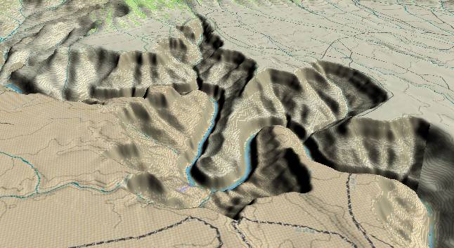
This picture
shows the same meander around Point Hansbrough, but this
time the view is toward the west-southwest. The Eminence
Fault enters at the center of the lower edge (where the
road reaches the rim of the canyon) and extends upward to
the left to where the narrow point out from the rim
begins. A second branch of the fault causes the “nick”
further out on the point.
Buck Farm Canyon is seen on the far side to the right of the meander (upstream) while Saddle Canyon extends toward the top edge to the left of the meander (downstream). In the far background, the east slope of the Kaibab Plateau is visible while the upper left corner catches a piece of Little Nankoweap Canyon.
Return to river miles 32 to 40
Continue to river miles 48 to 56
Return to the Index Page for the Grand Canyon Tour
Web page generated via Sea Monkey's Composer HTML editor
within a Linux Cinnamon Mint 18 operating system.
(Goodbye Microsoft)