
Durango Bill's
Grand Canyon 3-D Tour
Roaring Twenties Rapids to South Canyon
Grand Canyon Miles 24 to 32
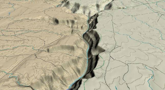
View to the
southwest with the Roaring Twenties Rapids at the bottom
edge and South Canyon entering from the top edge slightly to
the right of center. The Fence Fault extends from the lower
left corner diagonally upward to cross the river just this
side of South Canyon. Strata on the southeast side (upper
left quadrant) have been faulted downward by about 100 feet.
Shinumo Wash enters from the left a short distance this side
of South Canyon.
It is interesting to note the two small washes that enter from the left edge and cross the fault to continue over the up thrown side of the fault before plunging down to the river. These washes had to be in place before the fault became active since they ignore a potentially easier path following the fault. Since the whole surface area here has been exposed only in the last few million years, the washes are probably less than 3 million years old. Movement on the fault didn’t occur until the paths for the washes became established. Thus movement on the fault has been confined to about the last 2 million years.
The 1990 edition of “Grand Canyon Geology” has a table of recent earthquakes in the Grand Canyon area (page 441). In Jan. 1945 there was a magnitude 5.1 earthquake centered 2 miles up Shinumo Wash. (Note: While this epicenter sounds as if it were precisely located, there could easily be an error factor of several miles.)
The fault crosses the river just before the river turns left, and continues up South Canyon. Erosion along the fault line has probably contributed to why South Canyon developed at this particular location. Also, as the river crosses the fault it increases the downstream gradient of the river. Canyon cutting has worked its way back upstream from the fault, and is most likely the cause of the steeper river gradient in the vicinity of the Roaring Twenties Rapids. (See Grand Canyon Gradient for details.)
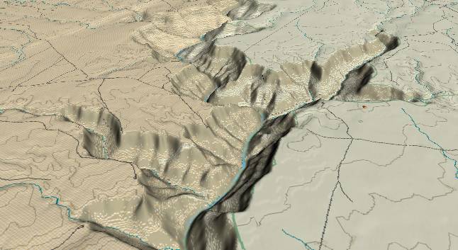
View to the
south-southwest with Shinumo Wash entering from the left
edge and South Canyon in the upper right quadrant. Two
of the scenic attractions within the Grand Canyon are
found in this stretch of the river, but unfortunately
neither shows up in this computer-generated picture.
Vasey's Paradise is an underground stream that bursts
from the canyon wall just where the river turns left and
disappears from view. This is only one of several
underground streams that have carved channels through
limestone layers within the Grand Canyon. This is how
caves are formed, and at some point in the distant
future, tourists may be exploring these future caves.
Redwall Cavern is a vast chamber in the left wall of the canyon slightly over a mile downstream (left) from South Canyon, but its exact location is obscured in this view.
Return to river miles 16 to 24
Continue to river miles 32 to 40
Return to the Index Page for the Grand Canyon Tour
Web page generated via Sea Monkey's Composer HTML editor
within a Linux Cinnamon Mint 18 operating system.
(Goodbye Microsoft)