
Durango Bill's
Grand Canyon 3-D Tour
Rider Canyon to the Roaring Twenties Rapids
Grand Canyon Miles 16 to 24
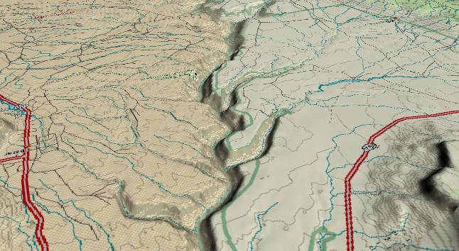
View to the
southwest with Rider Canyon in the right foreground, North
Canyon near the center, and the Roaring Twenties Rapids in the
distance (where the river bends slightly out of sight to the
right).
The Colorado River continues to cut ever deeper into the Marble Platform. The surface layer here is still the Kaibab Limestone. Within the canyon, the Kaibab, Toroweap, and Coconino Formations form the upper cliff. Then the Hermit Shale forms the slope half way down while the Supai forms the cliff down to river level. Just beyond North Canyon, the total depth of the canyon passes 2,000 feet.
The distinct cliff-slope-cliff pattern that is characteristic of the Grand Canyon (including the side canyons as well as the central gorge) is a product of direct cutting by the river augmented by gradual erosional widening into the multiple horizontal rock layers. Abrasive action by sand and rocks carried by the river produces a "sand blasting" effect that gradually deepens the channel. However, the main function of the river is to transport sand and gravel downstream and redeposit this silt in its delta (Tries to fill the gradually widening rift that has produced the Gulf of California).
As soon as river down-cutting exposes new surface area to atmospheric conditions, rock falls, flash floods (excavate side canyons), creep, slumps, etc. go to work to widen the canyon. (When eroded material gets down to the river it is removed as above.) Erosion is easiest in the shale layers as these have the weakest chemical bonds. If a shale layer initially has a steep slope, then the top of the shale layer will erode rapidly while any underlying, harder limestone or sandstone layer will support the base of the shale. Thus the steepness of the shale layer becomes less (which decreases the erosion rate) until the rate of erosion is in equilibrium with other layers. Since this weakness within the shale layer is more or less constant wherever it is exposed, the resulting surface steepness (slope) of the shale has approximately the same angle everywhere it is exposed whether it is in the main gorge or a side canyon.
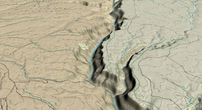
View to the
southwest with North Canyon in the right foreground, the
Roaring Twenties Rapids in the center where the river
curves to the right, and Shinumo Wash entering from the
left in the distance.
The river gradient in this section reaches 15 feet per mile centered at mile marker 24 - the steepest portion of the entire Marble Canyon section of the Grand Canyon. There are rapids at mile markers 23, 23.5, 24, 24.5, 25, and 25.5 as noted in Belknap's Grand Canyon River Guide.
The steeper gradient is probably a result of a small fault (the "Fence Fault") that can been seen entering near the center of the left edge and continuing diagonally upward to near the center of the top edge. The far side of this fault has been down dropped some 50 to 100 feet (probably fairly recently). The fault itself intersects the river just beyond mile 30. The strata displacement allows the river to drop more rapidly as it crosses the fault, and this additional drop quickly works it way back upstream to enhance canyon cutting.
Return to river miles 8 to 16
Continue to river miles 24 to 32
Return to the Index Page for the Grand Canyon Tour
Web page generated via Sea Monkey's Composer HTML editor
within a Linux Cinnamon Mint 18 operating system.
(Goodbye Microsoft)