
Durango Bill's
Grand Canyon 3-D Tour
Surprise Canyon to Salt Creek
Grand Canyon Miles 248 to 256
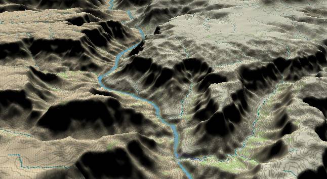
View to the
north-northwest with Surprise Canyon in the lower right
quadrant and Clay Tank Canyon joining the Colorado River from
the left a little above the bottom edge. In the middle
distance Horse Flat Canyon (Maxson Canyon) joins the river
from the left.
The Precambrian metamorphic rocks are still next to the river, but from here downstream the strata tilt downward. Thus the steep inner gorge will gradually disappear and be replaced by the sloping Bright Angel Shale. On top of the mesas the flat surface formed by the Esplanade Sandstone is over 3,500 feet above the river. The Kaibab, Toroweap, and Hermit Formations are still present as an outer rim to the distant northeast. Most texts state that the K-T formations have completely eroded away on the southwest (left) side of the river, but recent Google Earth images indicate that remnants of the old Kaibab/Toroweap outer rim still exist in isolated areas 10 to 15 miles W/WSW of Peach Springs, AZ. (This area is well off the left edge of the picture.)
The Precambrian metamorphic rocks are still next to the river, but from here downstream the strata tilt downward. Thus the steep inner gorge will gradually disappear and be replaced by the sloping Bright Angel Shale. On top of the mesas the flat surface formed by the Esplanade Sandstone is over 3,500 feet above the river. The Kaibab, Toroweap, and Hermit Formations are still present as an outer rim to the distant northeast. Most texts state that the K-T formations have completely eroded away on the southwest (left) side of the river, but recent Google Earth images indicate that remnants of the old Kaibab/Toroweap outer rim still exist in isolated areas 10 to 15 miles W/WSW of Peach Springs, AZ. (This area is well off the left edge of the picture.)
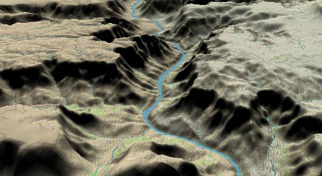
View to the
north-northwest with Horse Flat Canyon (Maxson Canyon)
entering from the left edge. For the next few miles the river
follows the Meriwitica Fault northward. Then the river curves
back to the northwest, but the fault continues northward.
Erosional weakness along the fault has created Salt Creek
Canyon.
The last remnant of the basaltic lava flows is found to the right of the river about a mile before Salt Creek. As measured from Prospect Canyon this longest flow reached 75 miles downstream.
Return to river miles 240 to 248
Continue to river miles 256 to 264
Return to the Index Page for the Grand Canyon Tour
Web page generated via Sea Monkey's Composer HTML editor
within a Linux Cinnamon Mint 18 operating system.
(Goodbye Microsoft)