
Durango Bill's
Grand Canyon 3-D Tour
Separation Canyon to Surprise Canyon
Grand Canyon Miles 240 to 248
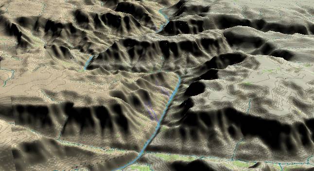
View to the
west-northwest with Separation Fault and its twin canyons
along the lower edge. The river turns sharply to the left at
242 Mile Canyon and then back to the right just before Spencer
Canyon enters from the left edge. Surprise Canyon enters from
the right just beyond the ridge.
The inner gorge (Lower Granite Gorge) is composed of Precambrian schist capped by Tapeats Sandstone. Then the Bright Angel Shale forms its characteristic slope. Cambrian, Devonian, and Mississippian limestones form the major cliff. The Supai Group (with its flat Esplanade Sandstone top) forms the mesas.
Erosion along one of the many northeast to southwest faults in the area has caused 242 Mile Canyon as well as allowing the Colorado River to make a zigzag to the left.
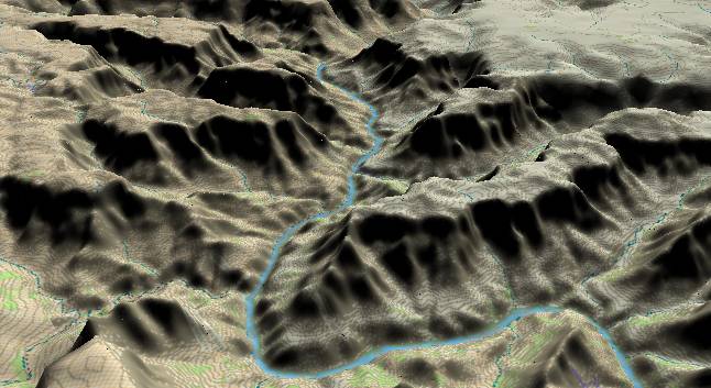
View to the
northwest with 242 Mile Canyon joining the river where it
makes a sharp turn to the left. Spencer Canyon enters from the
left edge and joins the river after it makes another sharp
turn, but to the right. Surprise Canyon is the next major
canyon that enters from the right.
Before Lake Mead backed up to fill the lower end of the Grand Canyon, there was another major rapid where Spencer Canyon joins the river. The rapid was named Lava Cliff Rapid after a large remnant of the old lava flows that is still stuck to the north bank. The top of the flow is some 80 feet above the current river level. Since the old river channel is still lower yet, it indicates there has been moderate downward cutting by the river since the lava flow was in place.
Surprise Canyon is significant as it is the place name for the Surprise Valley Formation. After the Redwall Limestone was deposited some 350 million years ago, this area emerged above sea level. Rivers developed across the area and formed small river valleys. Subsequently these valleys were filled in with silt to form the Surprise Valley Formation. Part of this was eroded again before the entire area was covered with the Supai Group.
Return to river miles 232 to 240
Continue to river miles 248 to 256
Return to the Index Page for the Grand Canyon Tour
Web page generated via Sea Monkey's Composer HTML editor
within a Linux Cinnamon Mint 18 operating system.
(Goodbye Microsoft)