
Durango Bill's
Grand Canyon 3-D Tour
River Mile 232 to Separation Canyon (& Separation Rapid)
Grand Canyon Miles 232 to 240
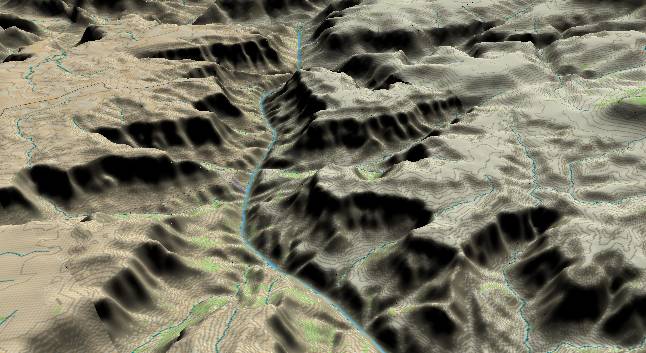
View to the
northwest with river mile 232 at the lower edge. In the center
of the picture, Bridge Canyon enters from the left edge with
Gneiss Canyon immediately above it, while 236 Mile Canyon is
across the river on the right side. Near the top edge of the
picture, the Separation Canyon Fault cuts across the river and
forms twin canyons.
Until recently, Bridge Canyon Rapid (at the mouth of Bridge Canyon) was the last rapid in the Grand Canyon as the Lake Mead backup buried everything else downstream. However, the current drought in the southwest has seriously lowered the water level in Lake Mead, and if Gneiss Canyon Rapid and 237 Mile Rapid have not reemerged yet, they will do so in the near future. Even more interesting, it is possible that Separation Rapid may resurface sometime in coming years.
The flat tops of the mesas are still the Esplanade Sandstone, with the slope-forming Watahomigi Formation just underneath. (Both are part of the Supai Group.) The Redwall and generic limestone layers then form a sheer cliff. Below these cliffs, the Bright Angel Shale forms a slope just above the inner gorge. Then the Tapeats Sandstone and Precambrian metamorphic rocks form a cliff down to the Colorado River.
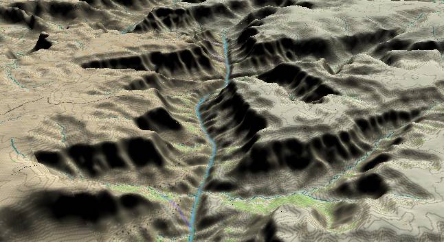
View to the
northwest with 236 Mile Canyon in the right foreground. The
Separation Canyon Fault crosses in the middle of the picture
and erosion along the fault has produced twin canyons.
In Aug. 1869 three men from Powell's original group decided to leave and hike out of the Grand Canyon via Separation Canyon. They started up the north (right) canyon and were never heard from again.
Of geologic interest there is a very small bump just in front of the left end of the leftward continuation of Separation Canyon. This is a remnant of a 19 million year old lava flow, and indicates the flat Esplanade surface hasn't changed much in 19 million years except where the Colorado River has dug the canyon.
Return to river miles 224 to 232
Continue to river miles 240 to 248
Return to the Index Page for the Grand Canyon Tour
Web page generated via Sea Monkey's Composer HTML editor
within a Linux Cinnamon Mint 18 operating system.
(Goodbye Microsoft)