
Durango Bill's
Grand Canyon 3-D Tour
Diamond Peak to River Mile 232
Grand Canyon Miles 224 to 232
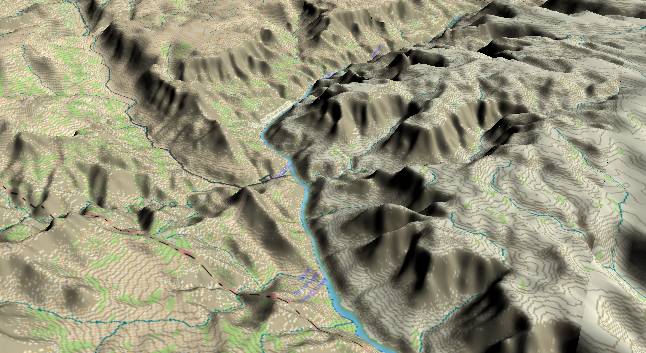
View to the west-southwest with Diamond Peak near the center. (It’s the small ridge to the left of the river with the “road” coming down Peach Springs Canyon behind it.) The last major branch of the Hurricane Fault continues to the left up Peach Springs Canyon. After the Colorado River turns to the right, the cross section of the canyon becomes symmetrical again.
Next to the river, a new inner gorge has developed as the river cuts down into Tapeats Sandstone and Precambrian schist very similar to the Vishnu Schist that underlies the Kaibab Plateau some 140 miles back upstream. Just above these layers, the Bright Angel Shale forms a small slope. River gradient picks up again to over 10 ft./mi.
In the distance near the center of the top edge, Travertine Canyon is named for the abundant amounts of travertine (dissolved and redeposited calcium carbonate) that occur in this part of the Grand Canyon.
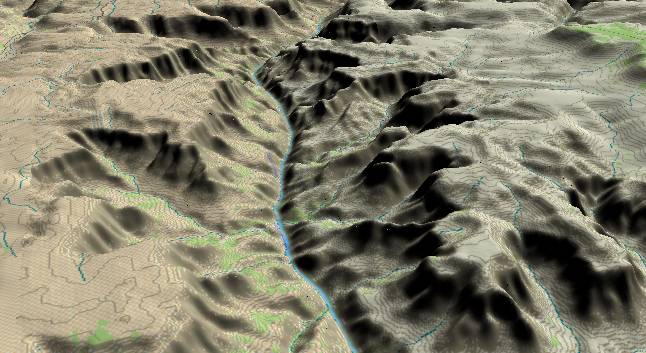
View to the
west-northwest with Travertine Canyon in the left
foreground. 231 Mile Canyon is a little further back to
the right, and river mile 232 is reached after the river
has completed most of its slight turn to the left.
The inner gorge here is a result of the river cutting down through the Tapeats Sandstone and into the underlying Precambrian schist. While the sides of the inner canyon are not quite as precipitous as the inner gorge in the Kaibab Plateau, the sharp V shape and relative lack of intra-canyon remnants of the lava flows suggests there is canyon cutting currently in progress in this area, but not to the degree seen on the west side of the Kaibab Plateau.
The Bright Angle Shale is above the Tapeats and forms its usual slope. Then the cliff is formed by assorted limestone layers with the sheer cliff of the Redwall at the top.
The lowest member of the Supai Group then forms the broad slope above the Redwall, and the Esplanade Sandstone caps this with a flat layer. The slope-forming Hermit Shale is next. Finally, the Kaibab/Toroweap cliffs show up at the right edge which completes the journey to the top of the Shivwits Plateau. (The Coconino Sandstone is not present in this area as it thins and disappears to the west of the Hurricane Fault.)
Return to river miles 216 to 224
Continue to river miles 232 to 240
Return to the Index Page for the Grand Canyon Tour
Web page generated via Sea Monkey's Composer HTML editor
within a Linux Cinnamon Mint 18 operating system.
(Goodbye Microsoft)