
Durango Bill's
Grand Canyon 3-D Tour
Start of Lower Granite Gorge to Diamond Peak
Grand Canyon Miles 216 to 224
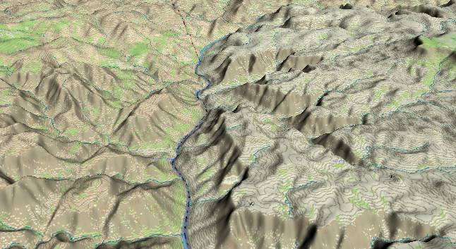
View to the
south-southwest with Three Springs Canyon just above the lower
left edge and 217 Mile Canyon above it near the center of the
picture. To the right of the river, also near the middle of
the picture, Trail Canyon has developed along one of the many
faults in the area. The Hurricane Fault System (has several
local branches) remains left of and parallel to the Colorado
River.
Just after Three Springs Canyon the strata have tilted upward enough to bring the Precambrian metamorphic rocks back to the surface. However, the canyon near the river remains asymmetrical until the river turns westward to the right of Diamond Peak (small ridge in-between the county line and the river – near the top edge).
Just after Three Springs Canyon the strata have tilted upward enough to bring the Precambrian metamorphic rocks back to the surface. However, the canyon near the river remains asymmetrical until the river turns westward to the right of Diamond Peak (small ridge in-between the county line and the river – near the top edge).
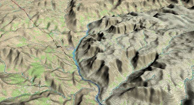
View to the
southwest with Granite Spring Canyon entering along the
lower left edge and 220 Mile Canyon in the lower right
quadrant. Diamond Peak appears as a ridge in-between the
county line and the river where it turns to the right on a
more westerly course.
There are several branches of the Hurricane Fault that are just east (left) of the river. A major branch continues to the east (left) of Diamond Peak, and erosion along the fault has produced Peach Springs Canyon. The Colorado River established and was imbedded in its current course before the Hurricane Fault system became active. Hence it has ignored potential erosional weakness caused by the fault.
Total uplift to the east of the fault is about 1,400 feet. Where the river starts to turn right at the county line, the Tapeats Sandstone to the west of the river is about 250 feet above the river level. To the east (left) several layers of the Tapeats are present. Each time a branch of the Hurricane Fault encounters the Tapeats, the eastern side of the fault lifts the Tapeats to higher elevations. Thus it has several exposures with the highest some 1,600 feet above the river.
Return to river miles 208 to 216
Continue to river miles 224 to 232
Return to the Index Page for the Grand Canyon Tour
Web page generated via Sea Monkey's Composer HTML editor
within a Linux Cinnamon Mint 18 operating system.
(Goodbye Microsoft)