
Durango Bill's
Grand Canyon 3-D Tour
Granite Park to start of Lower Granite Gorge
Grand Canyon Miles 208 to 216
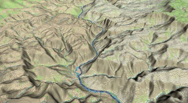
View to the south
with 209 Mile Canyon entering from the lower right edge and
joining the Colorado River just before the large flat island
in Granite Park. The diagonal line starting about midway on
the left edge (and trending toward the river in the distance)
is the main branch of the Hurricane Fault. Movement along the
fault fractures underlying rock making it easier for periodic
rainstorms to erode away the surface. Thus, valleys and
canyons tend to develop along fault lines.
One of the side branches of the fault just grazes the river near the island in Granite Park, and then continues south-southeastward from there. Uplift to the east of this branch has brought Precambrian schist and granite to the surface to the left of the river just upstream from the island.
Downstream from here the rock walls next to the river here are composed of the Tapeats to Supai Paleozoic layers. However, the strata generally slope upward to the south, and as a result the Precambrian basement rocks will begin to show up again – especially to the left (east) where they have been uplifted to the east of the Hurricane Fault. There are still patches of the lava flows near the river, but they are becoming steadily sparser as the river gets further from the volcanic source zones.
In the western part of the Grand Canyon, the Hualapai Drainage system was eroding broad valleys down to the Esplanade Sandstone surface long before the Colorado found its new route across the Kaibab Plateau. As a result the outer rim formed by the Kaibab, Toroweap, Coconino, and Hermit formations has eroded back to where it usually cannot be seen from the river.
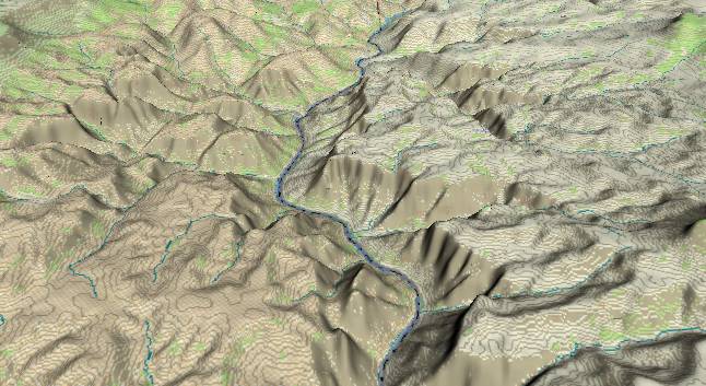
View to the
south with Three Springs Canyon entering from the left
(east) slightly above the midpoint of the picture. Lower
Granite Gorge begins just after Three Springs Canyon as
the 1.7 billion year old Precambrian metamorphic rocks
begin to rise above river level.
If you are rafting the river, there is an orange-colored spring on the left side of the river just before it starts its gradual turn to the left (Just above the bottom edge of the picture). This is “Pumpkin Spring” which is also known as “Charlie Brown’s Great Pumpkin”. Drinking the water from the spring is not advised as it has a high arsenic content.
The Hurricane Fault stays just to the left of the river through this section. The maximum displacement along the fault is some 2,400 feet about where it intersects Three Springs Canyon. The 2,400 foot displacement is actually partitioned across a series of local faults spread across the entire fault zone.
Return to river miles 200 to 208
Continue to river miles 216 to 224
Return to the Index Page for the Grand Canyon Tour
Web page generated via Sea Monkey's Composer HTML editor
within a Linux Cinnamon Mint 18 operating system.
(Goodbye Microsoft)