
Durango Bill's
Grand Canyon 3-D Tour
Mollies Nipple to Granite Park
Grand Canyon Miles 200 to 208
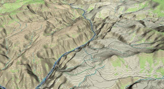
View to the south
with Mollies Nipple in the lower right quadrant. In the middle
distance, 205 Mile Canyon is left (east) of the Colorado River
and joins it near the top edge. At the top edge, the canyon
will open up a bit to the left at Granite Park.
If you compare this portion of the Grand Canyon with almost any other canyon, it would still be very impressive; but if you compare it with portions of the Grand Canyon upstream from the Hurricane Fault at mile 191, it has become quite dull. The generic limestone cliffs bordering the river still rise up 2,500 feet, but they are not as sheer as those seen further upstream.
Where the river extends furthest to the right, there is a remnant of an old lava flow that extends below the current surface level. This indicates the canyon was deeper than it is now when the flow occurred. This means there has been little net down cutting of the canyon here for the last million years, and the only thing that erosion is doing is gradually widening the canyon.
Rocks next to the river are mostly Bright Angel Shale capped by remnants of two major lava flows. As we proceed downstream, the river will slowly work its way into the lower Tapeats Sandstone and Precambrian layers.
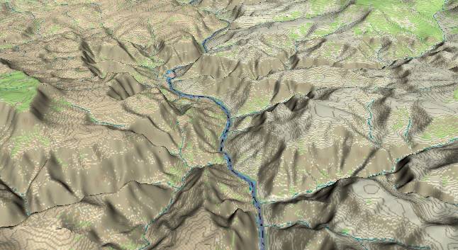
View to the south
with Spring Canyon entering from the lower right edge, and
205 Mile Canyon entering from the left side. In the upper
left portion of the picture there is an island in the middle
of the river at Granite Park.
From river mile 205 to about mile 213 there are several sections where large blocks of the canyon wall have broken loose and are slowly sliding downward. Typically, the base of a slumping block slides outward with the top sliding down in back. This resulting backward rotation will tilt the strata within the block upward on the side next to the river. (downward at the back of the block next to the stable cliff.) If you have Norman Beerger's Grand Canyon video (Recommended Video), you can see several of these slumping blocks (characterized by the reverse rotation) on the west side of the river just north of mile 213.
Return to river miles 192 to 200
Continue to river miles 208 to 216
Return to the Index Page for the Grand Canyon Tour
Web page generated via Sea Monkey's Composer HTML editor
within a Linux Cinnamon Mint 18 operating system.
(Goodbye Microsoft)