
Durango Bill's
Grand Canyon 3-D Tour
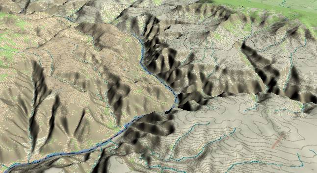
Hurricane Fault at 192 Mile Canyon to Mollies Nipple
Grand Canyon Miles 192 to 200
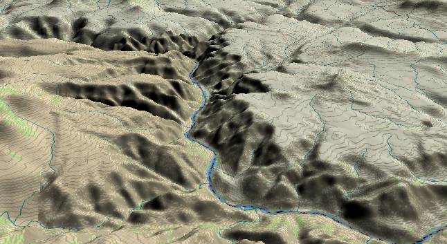
View to the
west-northwest with the Hurricane Fault just above and
parallel to the bottom edge. Erosion along the fault has
created 192 Mile Canyon at the extreme lower left, but
drainage from higher elevations (off the edge to the left)
uses 193 Mile Creek to join the Colorado River (just after it
turns to the west). Near the top edge and right of center,
Lone Mountain is bounded by two parallel northwest to
southeast faults. The river turns south (left) again where
Parashant Wash/Fault meets the river.
The vertical walls of the inner gorge that were prevalent to the east of the Toroweap Fault are much gentler through this section. First, the multiple faulting here has opened many fractures allowing easier erosion. Secondly, this part of the canyon has only had minimal down cutting in the last one million years. Hence erosion only widens the canyon instead of deepening it.
Rock layers next to the river consist of remnants of lava flows overlying Muav Limestone and Bright Angel Shale.
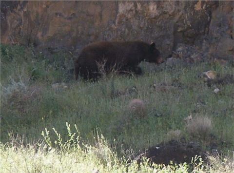
Bears are rarely seen at river level in the Grand Canyon, but the photograph above was taken by a member of a late March/early April raft trip that the author was on in 2005. (Raft trip was organized by Jan Taylor with Ivo Lucchitta as our guest geologist - see http://groups.yahoo.com/group/GC_Geological_Rafting/ .)
It had been a wet late winter/early spring with resulting lush early spring vegetation at river level in the Grand Canyon. The bear was contentedly munching on the lush vegetation when he was surprised by the lead raft. (Note the Barrel Cactus just below the bear.)
“Mr. Bear” presumably decided that “retreat” was a better option than arguing with something bigger than he was (the raft) and started to make a quick exit – but not before he was duly recorded as an entry in the record books.
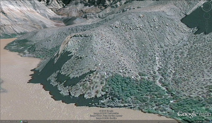
The picture above is a Google Earth view of the left (southeast) side of the river at mile 194.0. The bear had been munching on lush vegetation just below the small cliff that can be seen next to the river - just above the label at the bottom center of the picture.
When the bear was frightened off by our lead raft, he first ran around the right edge of the small cliff and then doubled back to the left to climb the ridge in the center of the picture. By the time the rest of the rafts in our group had caught up, the bear had climbed the 300-foot high ridge, and was only a speck on the skyline.
I was in the 2nd raft and got a distant view of the whole episode. People in the last raft never did get a good view. For the rest of the trip we were all making jokes about “the giraffe” in the Grand Canyon, and/or “You saw a bear? – Of course we believe you.”, etc.; but the photo is legit.
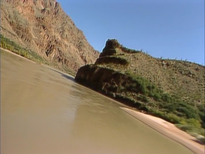
The picture above is a Print Screen image from Norman Beerger’s video “The Grand Canyon”. (See http://www.durangobill.com/GCvideo.html )
The video gives a helicopter tour of the Grand Canyon. The helicopter happened to be flying low just above the river and was banking to the left as it passed “The bear’s location”. As noted above, the bear had been on the slope just below the small cliff next to the river, ran around the right end of the cliff, and then double-backed to the left to run up to the top of the ridge.
Also please see Ed Pollock’s article on pages 22 and 23 of the Fall 2005 issue of Boatman’s Quarterly Review. http://www.gcrg.org/bqr/pdfs/18-3.pdf (Includes another photo of the bear.)
The vertical walls of the inner gorge that were prevalent to the east of the Toroweap Fault are much gentler through this section. First, the multiple faulting here has opened many fractures allowing easier erosion. Secondly, this part of the canyon has only had minimal down cutting in the last one million years. Hence erosion only widens the canyon instead of deepening it.
Rock layers next to the river consist of remnants of lava flows overlying Muav Limestone and Bright Angel Shale.
A Bear in the
Grand Canyon
Bears are rarely seen at river level in the Grand Canyon, but the photograph above was taken by a member of a late March/early April raft trip that the author was on in 2005. (Raft trip was organized by Jan Taylor with Ivo Lucchitta as our guest geologist - see http://groups.yahoo.com/group/GC_Geological_Rafting/ .)
It had been a wet late winter/early spring with resulting lush early spring vegetation at river level in the Grand Canyon. The bear was contentedly munching on the lush vegetation when he was surprised by the lead raft. (Note the Barrel Cactus just below the bear.)
“Mr. Bear” presumably decided that “retreat” was a better option than arguing with something bigger than he was (the raft) and started to make a quick exit – but not before he was duly recorded as an entry in the record books.
The picture above is a Google Earth view of the left (southeast) side of the river at mile 194.0. The bear had been munching on lush vegetation just below the small cliff that can be seen next to the river - just above the label at the bottom center of the picture.
When the bear was frightened off by our lead raft, he first ran around the right edge of the small cliff and then doubled back to the left to climb the ridge in the center of the picture. By the time the rest of the rafts in our group had caught up, the bear had climbed the 300-foot high ridge, and was only a speck on the skyline.
I was in the 2nd raft and got a distant view of the whole episode. People in the last raft never did get a good view. For the rest of the trip we were all making jokes about “the giraffe” in the Grand Canyon, and/or “You saw a bear? – Of course we believe you.”, etc.; but the photo is legit.
The picture above is a Print Screen image from Norman Beerger’s video “The Grand Canyon”. (See http://www.durangobill.com/GCvideo.html )
The video gives a helicopter tour of the Grand Canyon. The helicopter happened to be flying low just above the river and was banking to the left as it passed “The bear’s location”. As noted above, the bear had been on the slope just below the small cliff next to the river, ran around the right end of the cliff, and then double-backed to the left to run up to the top of the ridge.
Also please see Ed Pollock’s article on pages 22 and 23 of the Fall 2005 issue of Boatman’s Quarterly Review. http://www.gcrg.org/bqr/pdfs/18-3.pdf (Includes another photo of the bear.)
View to the
southwest with Parashant Wash entering from the right edge.
Mollies Nipple is the conical mountain rising above the
Esplanade surface (to the right of the river) and is an
isolated remnant of the North Rim. The green plateau in the
upper right corner is part of the Shivwits Plateau (North
Rim).
There are still many remnants of lava flows that are found alongside the river. The Bright Angel Shale and Tapeats Sandstone layers were exposed at river level before the lava flows of the last one million years, and the present depth of the canyon hasn't changed much. However, erosion is slowly widening the gorge.
The cliffs above the river still contain the Muav and Redwall Limestone units that started way back in the Marble Canyon section, but other limestone units (mostly of Devonian age) also contribute in western areas of the Grand Canyon. The Redwall is no longer the reddish color since the Hermit Shale that stained it has now retreated further back from the edge. Thus for the rest of the canyon, these units all tend to blend into "generic limestones".
Return to river miles 184 to 192
Continue to river miles 200 to 208
Return to the Index Page for the Grand Canyon Tour
Web page generated via Sea Monkey's Composer HTML editor
within a Linux Cinnamon Mint 18 operating system.
(Goodbye Microsoft)