
Durango Bill's
Grand Canyon 3-D Tour
Mile 184 to the Hurricane Fault at 192 Mile Canyon
Grand Canyon Miles 184 to 192
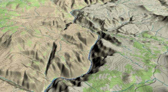
View to the
southwest. Mile marker 184 is just above the lower edge of the
picture where the Colorado River begins to curve back toward
the left. There are multiple lava flows and volcanic cinder
cones in this section with several cinder cones visible to the
right of the river. The river meets multiple local branches
within the Hurricane Fault Zone in the middle distance where
it turns left again (just before Whitmore Wash/Canyon).
This area is on the west side of the Toroweap Fault and thus on the "down" side. Hence there has been less net downward cutting by the river over the last million years. The inner gorge thus records a million year cyclic history of canyon cutting, partial filling by lava flows, followed by more canyon cutting, more lava flows, etc.
The Bright Angel Shale that surfaced to the east of the Toroweap Fault is initially dropped back below the surface west of the Toroweap Fault, but the strata still tilt upward toward the west. Within a few miles the Bright Angel surfaces again as well as the lower Tapeats Sandstone and the top few feet of the underlying Precambrian schist and granite. Then, west of the Hurricane Fault, these layers are dropped below the surface again.
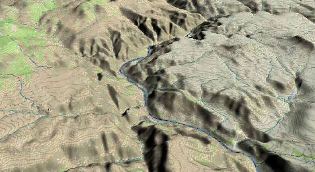
View to the
west-southwest with Whitmore Wash/Canyon in the lower
right quadrant. The Hurricane Fault enters from the lower
right edge (several local branches) and continues across
the picture through 192 Mile Canyon to the upper left
corner. The strata layers on the far side have been
faulted downward by some 1,300 feet. (The picture below
illustrates this.) In the upper left quadrant of the
picture, erosion along the Hurricane Fault Zone has
created 192 Mile Canyon. However, the creek that comes
down the upper part of the fault zone follows a drainage
pattern established before the Hurricane Fault was active,
and ignores the fault by turning westward to join the
Colorado River at mile 193.
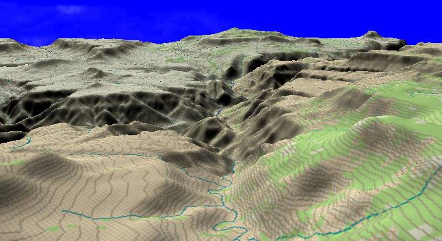
This view
looking due north from about Mile 192 covers the same
area as that shown above, but looks along the fault
zone to illustrate the 1,300-foot displacement. The
topmost surface rock on both sides of the fault is the
Kaibab Limestone. An even better guideline is the
Esplanade surface of the Supai Group. To the right of
the fault (east) the Esplanade surface forms the
sloping surface starting in the lower right corner.
This same flattish layer is over 1,000 feet lower to
the left of 192 Mile Canyon (which is in the center
foreground).
Return to river miles 176 to 184
Continue to river miles 192 to 200
Return to the Index Page for the Grand Canyon Tour
Web page generated via Sea Monkey's Composer HTML editor
within a Linux Cinnamon Mint 18 operating system.
(Goodbye Microsoft)
Return to river miles 176 to 184
Continue to river miles 192 to 200
Return to the Index Page for the Grand Canyon Tour
Web page generated via Sea Monkey's Composer HTML editor
within a Linux Cinnamon Mint 18 operating system.
(Goodbye Microsoft)