
Durango Bill's
Grand Canyon 3-D Tour
Toroweap Point to Lava Falls Rapid and Mile 184
Grand Canyon Miles 176 to 184
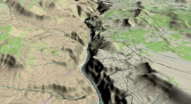
View to the
west-southwest with Toroweap Point (North Rim) in the lower
right corner. A dirt road (broken black line) extends to the
Toroweap Overlook with Vulcans Throne (a volcanic cinder cone)
just above it. The Toroweap Fault enters from the right edge
(near the road) and continues leftward thru the front side of
Vulcans Throne and across the river through Prospect Canyon.
The far side of the fault has been down dropped some 600 feet.
This section of the Grand Canyon has seen a great deal of volcanic activity in the last million years. Multiple lava flows have cascaded into the canyon forming dams and temporarily created lakes up to several hundred miles long. Each time lava has blocked the channel, the Colorado River has gone to work to re-excavate the canyon. Vulcans Throne has been active as recently as 74,000 (+/- 4,000) years ago while cinder cones have been active even more recently in Prospect Canyon.
Prospect Canyon is of particular interest. It has been filled several times with lava flows and is only just starting to erode a new canyon down to the river. Also, these lava flows sit right on the fault line, and each time the fault moves, it shatters some of the old lava. The watershed for the canyon extends some 20 miles further south, which means a large amount of water can come down the canyon during a flash flood. The combination of large amounts of water, shattered rock, and a steep drop to the bottom of the Grand Canyon allows large volumes of debris to pile up where it meets the Colorado River. The result is Lava Falls Rapid.
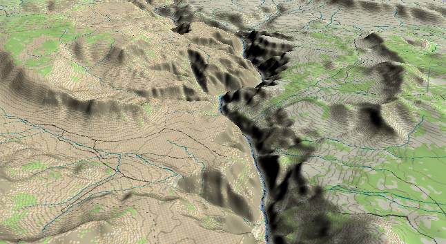
View to the
west-southwest with Vulcans Throne in the lower right corner
and Prospect Creek/Canyon entering from the left edge. Lava
Falls Rapid is near the bottom edge where Prospect Creek joins
the Colorado. River mile 184 is in the distance where the
river is furthest to the right.
Most of the Prospect Canyon debris fan was deposited in a huge debris flow about 3,000 years ago. This river blockage is responsible for Lava Falls Rapid and also backed up the Colorado River for at least 20 miles. River gradient is still relatively low for 20 miles upstream.
Prior to 1939 it was debatable whether Lava Falls or Hance Rapid was the "baddest" on the river. Then another debris flow (estimated at 35,000 cu. ft. per sec.) down Prospect added to the debris fan and settled the issue. In 1966 a major debris flow down Crystal Creek created Crystal Rapid and once again there is a "baddest" debate. Prospect Canyon had another debris flow on March 6, 1995 that constricted Lava Falls Rapid again, but not enough to settle the issue. As to which rapid will become the worst - stay tuned. It might happen just as you start a future raft trip.
Near the center of the picture, the river bends slightly to the left before cutting back to the right. Before the series of lava flows that started about 1.2 million years ago, the river took a straighter path through this section. Then black basaltic lava flows from the north (right side of the river) filled in the old inner gorge and forced the river up against the left wall of the canyon. The river subsequently eroded straight down in this new deflected path. If you are rafting the river, the right side of the canyon reveals a cross section of the former, filled-in channel.
Return to river miles 168 to 176
Continue to river miles 184 to 192
Return to the Index Page for the Grand Canyon Tour
Web page generated via Sea Monkey's Composer HTML editor
within a Linux Cinnamon Mint 18 operating system.
(Goodbye Microsoft)