
Durango Bill's
Grand Canyon 3-D Tour
Kanab Creek to Boysag Point
Grand Canyon Miles 144 to 152
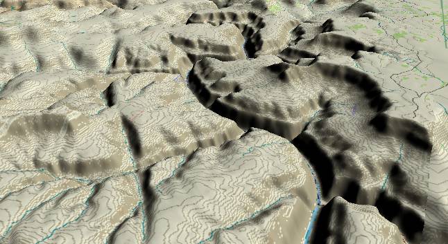
View to the
west-southwest with Kanab Creek entering the Colorado River
from the lower right corner and Kanab Point just above it.
Paquekwash Point is in the middle distance to the right of the
river. On the left side of the river, Olo Canyon is in the
foreground and Matkatamiba Canyon is in the distance just
before the river makes a sharp right turn. Erosion along the
Sinyala Fault forms the long line from the lower edge (left of
center) up and left toward the top edge.
The usual Kaibab/Toroweap/Coconino layers still form the cliff edge that defines the North Rim at Kanab Point. Then the Hermit Shale erodes down to the flat surface of the Esplanade Sandstone.
The Esplanade represents the flat valley floor that was here before the Colorado River found its present route across the Kaibab Plateau some 5.4 million years ago. Since then (and mostly in the last 2 to 3 million years) the Colorado has cut down through the rest of the Supai Group (smaller cliff and slope at the top of the inner gorge) and the Redwall/Muav Limestones to form the sheer cliff down to river level.
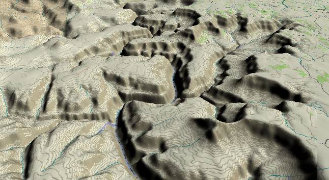
View to the
west-southwest with Matkatamiba Canyon in the lower left
quadrant and 150 Mile Canyon to the right of center. The North
Rim is visible along the right edge and the narrow ridge in
the distance that extends toward the center of the picture is
Boysag Point. The Esplanade surface (top of the Supai Group)
forms the flat surface between the outer rim and the inner
gorge. In the upper left, the small “bump” is Mt. Sinyala
which is a remnant of the South Rim.
The river is still confined to a narrow inner gorge with near vertical sidewalls of Redwall and Muav Limestone. In this section of the Grand Canyon, the strata near the river actually bend upward in a small anticline with an axis along the river. The river has removed the thousands of feet of rock in its path, and this allows the strata in the riverbed to bend and rebound upward a bit as the overlying weight has been removed.
Return to river miles 136 to 144
Continue to river miles 152 to 160
Return to the Index Page for the Grand Canyon Tour
Web page generated via Sea Monkey's Composer HTML editor
within a Linux Cinnamon Mint 18 operating system.
(Goodbye Microsoft)