
Durango Bill's
Grand Canyon 3-D Tour
Deer Creek Falls to Kanab Creek
Grand Canyon Miles 136 to 144
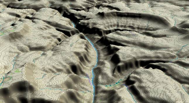
View to the
west-northwest with Deer Creek (and Deer Creek Falls) joining
the Colorado River in the right foreground. In the middle
distance, 140 Mile Canyon joins from the left and Fishtail
Canyon enters from right. Kanab Creek enters from the right
along the extreme upper edge.
A popular hike for rafting groups is to climb up from the river at the base of Deer Creek Falls to at least reach the open valley above the falls (small green area near the lower edge). As the trail zigzags up out of the schist and Tapeats Sandstone that forms the cliff next to the river, a spectacular view unfolds. ("Throat clutching view" might be equally descriptive.) If you continue to follow the creek up to Deer Spring (extreme lower edge of the picture), you get to see another large waterfall where the stream bursts out of a cave system in the limestone cliffs.
The trail up from the river uses a slope that is the result of a large slump (very slow motion landslide). Water is able to seep down through the broken material of the slump while the underlying solid rock keeps the water near the surface. As a result vegetation (including one of the few locations that Poison Ivy exists in the canyon) is able to grow in areas several hundred feet away from the river.
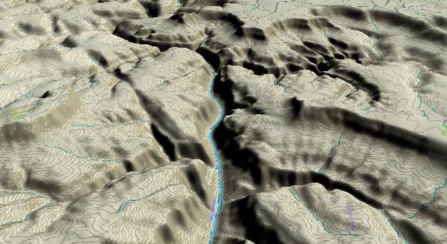
View to the west
with 140 Mile Canyon along the lower left edge and
Fishtail Canyon to the right. Kanab Creek enters from the
upper right edge while Fishtail Mesa is between Kanab and
Fishtail Canyons. As we go downstream from here, the
Kaibab/Toroweap/Coconino cliff that marks the outer rim of
the canyon gets further away from the river while the flat
Esplanade surface becomes more predominate.
The inner canyon becomes precipitous for the next 25 river miles as the strata containing the slope-forming Bright Angel Shale dips below river level. This brings the Redwall/Muav Limestone layers down to river level, and this combination produces a massive cliff. Another factor contributing to the steep inner gorge is the river's canyon-cutting that has propagated upstream from the Toroweap Fault.
The Sinyala Fault extends diagonally up and left from the center of the lower edge. Past movement along the fault has fractured the rocks making it easier for erosion to start digging side canyons.
Return to river miles 128 to 136
Continue to river miles 144 to 152
Return to the Index Page for the Grand Canyon Tour
Web page generated via Sea Monkey's Composer HTML editor
within a Linux Cinnamon Mint 18 operating system.
(Goodbye Microsoft)