
Durango Bill's
Grand Canyon 3-D Tour
128 Mile Canyon to Deer Creek Falls
Grand Canyon Miles 128 to 136
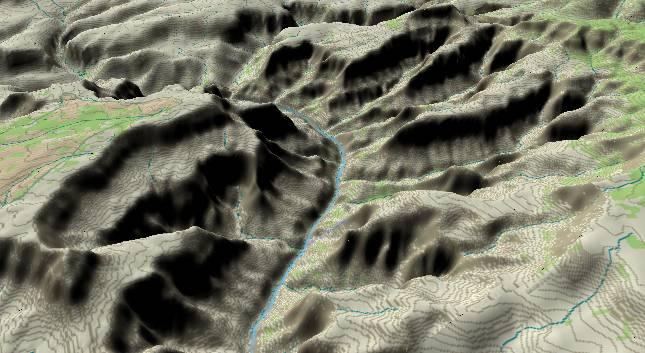
View to the
north-northeast with 128 Mile Canyon in the lower right
quadrant and Great Thumb Point (South Rim) left of the center.
Tapeats Creek is at the extreme top edge (trails to the right)
while the extreme right edge of the picture catches a piece of
the Powell Plateau.
In this portion of the Grand Canyon, the Colorado River has curved far enough eastward into the rising strata of the Kaibab Plateau to once again expose Precambrian layers. Initially, layers near the river are 1.7 billion year old schist, but another section of the Grand Canyon Supergroup strata is encountered as the river starts to curve back toward the west (to the left).
In this portion of the Grand Canyon, the Colorado River has curved far enough eastward into the rising strata of the Kaibab Plateau to once again expose Precambrian layers. Initially, layers near the river are 1.7 billion year old schist, but another section of the Grand Canyon Supergroup strata is encountered as the river starts to curve back toward the west (to the left).
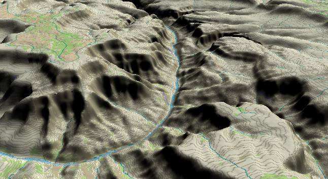
View to the
west-northwest with Great Thumb Point in the upper left
quadrant. Galloway and Stone Creek Canyons enter from the
bottom edge while in the distance Deer Creek enters from
the right edge. Tapeats Creek enters from the lower right
corner.
The cliff at river level through this section is a result of the river cutting down through the hard Bass Limestone and a diabase sill intruded between the underlying schist and the overlying Bass Limestone. In places the heat of the intrusion has cooked the limestone transforming it to marble.
Before reaching Deer Creek Falls the river passes through Granite Narrows, which at 76 feet is the narrowest portion of the river within the Grand Canyon. In this view the river nearly disappears as it goes through the narrows shortly before it gets to Deer Creek.
The narrows are a result of a landslide that slid down from the right side of the canyon a few tens of thousands of years ago. This blocked the old channel, and the river was pushed to the left where it had to dig a new gorge down through the bedrock. Digging a new gorge downward wasn’t much of a problem for the river, but it means the lowermost portion of the gorge is relatively young here. “Relatively young” means erosion hasn’t had as much time to widen the canyon – hence it is still narrow.
Return to river miles 120 to 128
Continue to river miles 136 to 144
Return to the Index Page for the Grand Canyon Tour
Web page generated via Sea Monkey's Composer HTML editor
within a Linux Cinnamon Mint 18 operating system.
(Goodbye Microsoft)