
Durango Bill's
Grand Canyon 3-D Tour
Blacktail Canyon to 128 Mile Canyon
Grand Canyon Miles 120 to 128
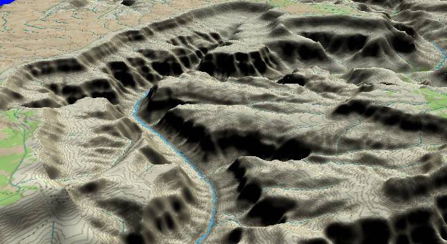
View to the
northwest with Blacktail Canyon slightly below the center
while Forster Canyon enters from the left edge. The South Rim
stretches across the top edge with Fossil Canyon near the
center, and reaches out toward Great Thumb Point at the upper
right.
The Tapeats Sandstone and Bright Angel Shale layers are once again next to the river, as the Precambrian layers have not been exposed here yet. The Colorado River straightens out for a few miles and serenely marches down Conquistador Aisle - bordered on both sides by massive cliffs of Redwall/Muav Limestone.
The Kaibab/Toroweap/Coconino complex still forms the cliff at the rim, but the broad flat Esplanade Sandstone surface is becoming more prevalent. The Esplanade surface defines what was here before the Colorado River overflowed the Kaibab Plateau about 5.4 million years ago. Earlier in the Miocene, the Hualapai drainage system had eroded broad canyons down to the Esplanade surface. By 6 million years ago this area looked like many other areas in the southwestern U.S. that are characterized by broad valleys that are bounded by steep canyon walls rising abruptly up to flat-topped mesas. When the river started flowing through here about 5.4 million years ago, it quickly eroded downward to cut the inner canyon.
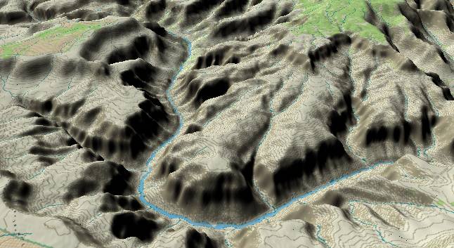
View to the
northeast with Fossil Canyon and Great Thumb Point on the
left (South Rim) side of the river. A piece of the Powell
Plateau (North Rim) can be seen in the upper right corner.
128 Mile Canyon is not exactly noteworthy, but it joins
the right hand side of the river just after it bends back
slightly to the right.
Fossil Canyon is aptly named. The Bright Angel Shale in this area has many fossils over 500 million years old.
This part of the river (that section that flows northeastward) is also interesting as it is flowing into rising strata layers. (Also rising surface topography if you disallow the canyon.) At one time it was thought that a "pirate stream" eroding from the west side of the Kaibab Plateau captured an ancestral Colorado River that existed to the east of the plateau. However, this would require the headwall erosion of the "pirate stream" to actually work its way back downhill through this section. This is of course impossible which is one of the reasons we can confidently say there was no "pirate stream".
Return to river miles 112 to 120
Continue to river miles 128 to 136
Return to the Index Page for the Grand Canyon Tour
Web page generated via Sea Monkey's Composer HTML editor
within a Linux Cinnamon Mint 18 operating system.
(Goodbye Microsoft)