
Durango Bill's
Grand Canyon 3-D Tour
Walthenberg Canyon to Elves Chasm to Blacktail Canyon
Grand Canyon Miles 112 to 120
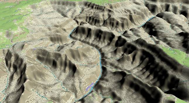
View to the west-southwest with Walthenberg Canyon and the Powell Plateau in the lower right quadrant. At the top of the picture Apache Point (South Rim) is directly above Marcos Terrace. Here, the Colorado River loops around Marcos Terrace, which is the ridge extending southward (up and left) from the Powell Plateau. The high point at the extreme southwest end of Marcos Terrace is Explorers Monument.
Only a thin sliver of the Precambrian basement rock is still above river level in this section, and it will disappear entirely a few miles further downstream. As measured from the rim, the rock layers here are:
1) Kaibab Limestone, Toroweap Limestone, Coconino Sandstone - cliff.
2) Hermit Shale - slope.
3) Esplanade Sandstone - flat surface
4) Rest of the Supai Group - fairly steep cliff
5) Redwall, Muav, and other limestones - sheer cliff
6) Bright Angel Shale - slope
7) Tapeats Sandstone - top of cliff next to the river
8) 1.7 to 1.8 billion year old basement rocks - remainder of cliff to river level
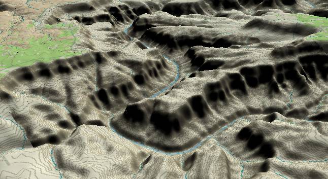
View to the
northwest with Elves Chasm in the lower left quadrant where
the river turns to the right and continues behind Explorers
Monument. Then, Blacktail Canyon enters from the right near
the center of the picture where the river bends back to the
left. Apache Point on the South Rim is in the upper left
quadrant. Some of the oldest rock in the Grand Canyon is found
near river level at Elves Chasm. It has been dated at 1.84
billion years old.
The Monument Fold (Fault) enters the picture slightly to the left of the center of the bottom edge, then passes slightly to the right of Explorers Monument, and then curves a little to the left to cross the river again. Strata to the right (northeast) of the Monument Fold are displaced downward. Thus the Precambrian layers drop below river level downstream from the Fold, and the slope associated with the Bright Angel Shale is brought down to river level near Blacktail Canyon. If you have a Belknap's River Guide, please note that the up/down thrown sides of this fault are labeled incorrectly. As can be seen in this picture (and as labeled on the Geologic Map of the Grand Canyon) it is the left (southwest) side of this fault that is uplifted.
Blacktail Canyon is one of the best places to see the 1-billion year age gap that forms the boundary between the Tapeats Sandstone and the underlying basement rock. Unfortunately, the resolution of the picture is not great enough to illustrate this, but if you are rafting the Colorado River, this boundary is clearly visible a short distance up Blacktail Canyon.
Return to river miles 104 to 112
Continue to river miles 120 to 128
Return to the Index Page for the Grand Canyon Tour
Web page generated via Sea Monkey's Composer HTML editor
within a Linux Cinnamon Mint 18 operating system.
(Goodbye Microsoft)