
Durango Bill's
Grand Canyon 3-D Tour
Ruby Canyon to Walthenberg Canyon
Grand Canyon Miles 104 to 112
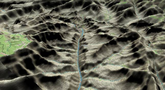
In this view to the
north-northwest, Ruby Canyon can be seen in the lower left
corner with Havasupai Point on the South Rim directly above
it. In the top portion of the picture and right of center,
weakness along the Crazy Jug Fault/Monocline has help generate
Muav Canyon. Muav Canyon continues further north to separate
the Powell Plateau from the rest of the North Rim.
The steep inner gorge is still composed of 1.7 billion year old Granodiorite complexes, but it is interesting to note that most of this cliff forming layer is faulted downward below the surface just before the river bends to the left at Shinumo Creek. The Grand Canyon Supergroup is exposed again around Shinumo Creek, and its sloping strata graphically display the Great Unconformity where it intersects the overlying horizontal Paleozoic Sequence.
The steep inner gorge is still composed of 1.7 billion year old Granodiorite complexes, but it is interesting to note that most of this cliff forming layer is faulted downward below the surface just before the river bends to the left at Shinumo Creek. The Grand Canyon Supergroup is exposed again around Shinumo Creek, and its sloping strata graphically display the Great Unconformity where it intersects the overlying horizontal Paleozoic Sequence.
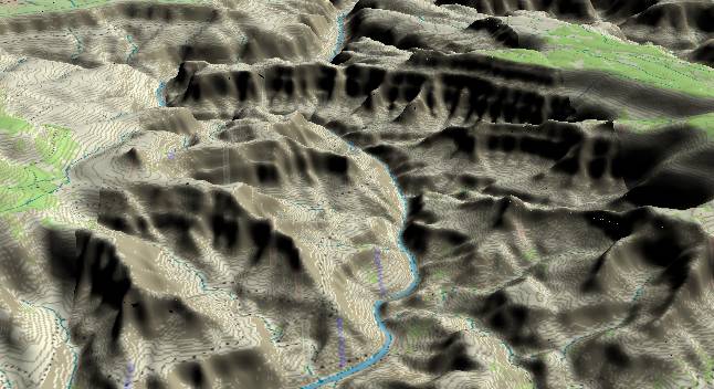
View looking
toward the west with Bass Canyon entering from the left in
the center foreground. In Precambrian time, a fault at
Bass Canyon dropped the strata to the right (downstream)
downward. This shows up today as a sudden disappearance of
the riverside cliff.
Shinumo Creek enters the river in the middle of the “S” curves at the lower right. Shinumo Creek drains a large area, and in the past its debris fan has pushed the Colorado River to the left thereby forming the “S” curves.
The lack of a large debris fan at the current time would indicate there haven’t been any large debris flows in recent history. However, there is still enough debris left to partially dam the river with the result that river gradient in this section is second only to the Hance Rapid portion of the river. At some point in the past (and possibly again sometime in the future) there was a major rapid here.
In the upper right portion of the picture, the green area represents the forested top of the Powell Plateau. The long ridge extending to the left is Marcos Terrace. Walthenberg Canyon is directly in front of it (before the river starts the long bend to the left), and both Marcos Terrace and the walls of Walthenberg Canyon show the classic massive cliff of the Redwall/Muav Limestones. (Note, both the Belknap and Stevens River Guides incorrectly omit the “h” in Walthenberg.)
Return to river miles 96 to 104
Continue to river miles 112 to 120
Return to the Index Page for the Grand Canyon Tour
Web page generated via Sea Monkey's Composer HTML editor
within a Linux Cinnamon Mint 18 operating system.
(Goodbye Microsoft)