
Durango Bill's
Grand Canyon 3-D Tour
Boucher Creek to Crystal Rapid to Ruby Canyon
Grand Canyon Miles 96 to 104
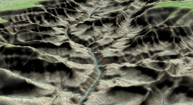
This
view to the northwest has Boucher Creek in the lower left
corner with a remote section of the South Rim stretching out
toward Havasupai Point in the distance. The North Rim at
Point Sublime can be seen in the upper right corner.
Slate Fault cuts left to right across the center of the picture. Of major interest to both rafters and geologists is Crystal Creek, which has developed along the fault. Crystal Canyon enters from the right edge and forms Crystal Rapid where it joins the Colorado River. Scorpion Ridge can be seen directly above the junction.
Prior to December 1966 there wasn't much more than a riffle at the base of Crystal Creek. Then a six-inch rainfall generated multiple debris flows that included 18-inch diameter Ponderosa Pine Tree logs that were carried at least 8 miles down from the North Rim. The resulting debris fan created Crystal Rapid. Robert Webb and Peter Griffiths have documented 168 tributaries to the Colorado River in the Grand Canyon that have had debris flows in modern history, but Crystal is the most dramatic. (More on recent debris flows when we get down to Lava Falls at mile 179)
There is always an argument as to whether Crystal or Lava Falls is the wildest rapid on the river, but historically, if you are going to have a problem on the river, Crystal is the most likely place. Page 376 "Grand Canyon Geology" by Beus and Morales has a photograph of a large motorized raft being completely swallowed by a standing wave in excess of "5 - 6 m." (16.5 to 20 ft.) at Crystal Rapid. On occasion, rafting trips have celebrated surviving Crystal Rapid with an "ABC Party" (Alive Below Crystal).
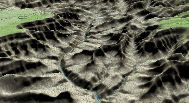
View to the
north-northwest with Scorpion Ridge in the center and the
South Rim's Havasupai Point in the distance. Ruby Canyon
enters from the left edge and joins the Colorado where the
river bends slightly to the left before straightening out. The
North Rim’s Point Sublime is again visible at the right edge.
The Crazy Jug Monocline/Fault has contributed to Tuna Canyon, which starts right of center and extends toward the top edge. The inner gorge is still composed of 1.7 billion year old basement rock although somewhat different than the Vishnu/Brahma Schists. The resistant Tapeats Sandstone forms the flattish shelf with the usual Paleozoic sequence above.
Return to river miles 88 to 96
Continue to river miles 104 to 112
Return to the Index Page for the Grand Canyon Tour
Web page generated via Sea Monkey's Composer HTML editor
within a Linux Cinnamon Mint 18 operating system.
(Goodbye Microsoft)