
Durango Bill's
Grand Canyon 3-D Tour
Phantom Ranch to Boucher Creek
Grand Canyon Miles 88 to 96
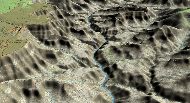
View looking toward
the west with Bright Angel Creek just above the lower right
edge. Grand Canyon Village can be seen at the left edge, and
parts of the Bright Angel Trail (leaves from the rim near the
village) can be faintly seen coming down Garden Canyon. In the
upper left corner Hopi and Pima Points are accessible via the
West Rim Drive, and provide viewpoints into the canyon.
A 1.7 to 1.8 billion year old complex of schist, gneiss, and granite characterizes the inner gorge. The flattish layer above this is the Tonto Plateau, which is formed where the Bright Angel Shale erodes down to the resistant Tapeats Sandstone. On the South Rim, the rest of the Paleozoic Sequence forms a nearly continuous cliff up to the rim, but the Redwall Limestone’s distinctive cliff is readily identifiable in the buttes to the north (right) of the river.
The combination of a still steep river gradient (> 10 ft/mi), a constricted channel, and steep tributary canyons (especially on the south side of the river) produces several short but abrupt rapids in this section of the Grand Canyon - including Horn Creek, Granite and Hermit Rapids.
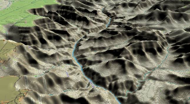
View looking to the
west-northwest with Hopi Point in the lower left corner and
the tip of Pima Point just above it. Monument Canyon is
in-between the two points, and debris that washes down it
feeds Granite Rapid. Hermit Canyon enters from the left
edge and produces another major rapid (Hermit Rapid) where it
dumps debris into the river. Where the river curves to the
right out of sight, Boucher Creek/Canyon generates still
another rapid, but Boucher Rapid doesn’t have the magnitude of
the others.
Return to river miles 80 to 88
Continue to river miles 96 to 104
Return to the Index Page for the Grand Canyon Tour
Web page generated via Sea Monkey's Composer HTML editor
within a Linux Cinnamon Mint 18 operating system.
(Goodbye Microsoft)
Return to river miles 80 to 88
Continue to river miles 96 to 104
Return to the Index Page for the Grand Canyon Tour
Web page generated via Sea Monkey's Composer HTML editor
within a Linux Cinnamon Mint 18 operating system.
(Goodbye Microsoft)