
Durango Bill's
Grand Canyon 3-D Tour
Cottonwood Creek to Grapevine Rapid/Creek to Phantom Ranch/Bright Angel Canyon
Grand Canyon Miles 80 to 88
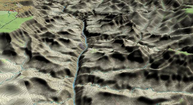
View to the
west-northwest with Cottonwood Creek just above the lower left
edge. Grapevine Creek (above Cottonwood Creek) enters from the
left edge and forms Grapevine Rapid where it joins the
Colorado River. Vishnu Creek is in the foreground on the right
side of the river. Shoshone/Yaki Point and Grand Canyon
Village (South Rim) can be seen in the upper left corner while
the vegetated top of Wotans Throne (middle) and Obi/Ariel
Point (distant) are part of the North Rim on the right edge.
This section forms the heart of the Upper Granite Gorge (inner gorge) and is the part most visitors see when they visit Grand Canyon National Park. Most of the inner gorge has been cut in the last one million years. The flattish surface immediately above the inner gorge is the Tonto Plateau which is formed when the softer Bright Angel Shale erodes down to the much more resistant Tapeats Sandstone.
The dashed lines (mostly on the left) are hiking trails. If you plan to hike in the canyon, make sure you have plenty of water. The consequences of running out of water are not good. On a raft trip I was on in Sept. 1996, some hikers at the base of the New Hance Trail flagged down our raft party. One of the hikers in the group had died of dehydration part way down the trail.
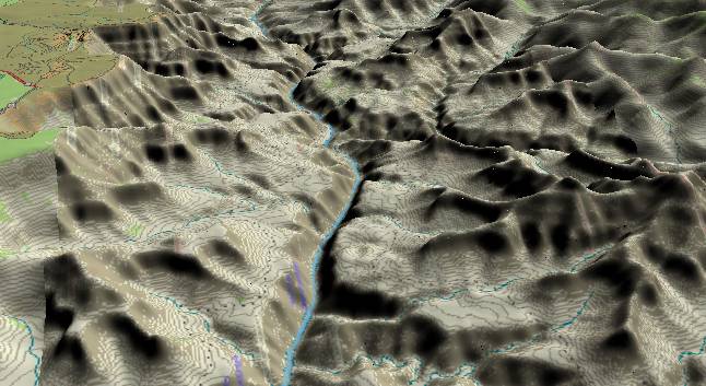
View to the
west-northwest. Clear Creek is just above the lower edge
to the right of the river with Bright Angel Canyon in the
middle distance above it. Phantom Ranch is a short
distance up Bright Angel Canyon, and has been a
destination point for visitors for generations (originally
via mule trips). Nowadays there are far more people that
hike down to the campground and camp out.
The upper left side of the picture shows the main visitor area on the South Rim with several observation points visible both to the east and west of Grand Canyon Village.
The Bright Angel Fault favors erosion along its trace as it fractures rocks making them easier to erode. The fault is thus a contributor to Bright Angel Canyon (right side of the picture) and Garden Canyon, which drops down from Grand Canyon Village. Fracturing along and near the fault leads to somewhat less precipitous cliffs. The Bright Angel Trail takes advantage of the “somewhat less precipitous cliffs” to descend from Grand Canyon Village to Phantom Ranch.
Return to river miles 72 to 80
Continue to river miles 88 to 96
Return to the Index Page for the Grand Canyon Tour
Web page generated via Sea Monkey's Composer HTML editor
within a Linux Cinnamon Mint 18 operating system.
(Goodbye Microsoft)